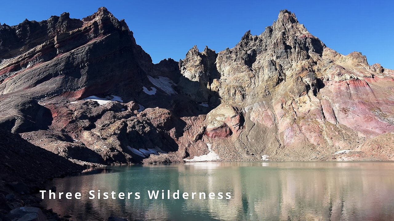
BITE-SIZED WILDS | THE EDGE OF THE TURQUOISE SHORELINE of No Name Lake & Broken Top! | 4K | Oregon
This was a 14-mile, 2600 FT Elevation Gain Day-Hike in Central Oregon, Three Sisters Wilderness, Deschutes National Forest, starting at Todd Trailhead and hiking to No Name Lake, Bend Glacier, & the Broken Top Zone as an EPIC Out and Back hike (PLEASE NOTE - this would be considered the "Longer Version" hike to get to No Name Lake & Bend Glacier from the South aka Todd Trailhead. You can also get to this destination by taking the "Shorter Version", Broken Top Trail. I prefer to do the longer version because it captures several very gorgeous and majestic sections of Three Sisters Wilderness that you wouldn't otherwise traverse if doing the shorter, more direct route. This entire section of Three Sisters Wilderness is a bit of a premium Alpine Wonderland, so why not capture it all is my perspective - to each their own of course. Lastly, I would mention that you can also get to No Name Lake & Bend Glacier from the East by means of Tam McArthur Rim Trail (permit required at Recreation.gov), I have that whole hike captured here as well in a separate Playlist: https://www.youtube.com/playlist?list=PLuGUSVzluAAmGSHgRwFLJprD8gBfZG53P
The East Tam McArthur Rim approach and longer Todd Trailhead South approach are my two recommended hikes out of the three).
This is one of my favorite hikes in all of Oregon, featuring my favorite Alpine Cirque Lake (No Name Lake), my favorite mountain (Broken Top), and my favorite Wilderness Area (Three Sisters). The hike starts at 6100 FT and your highest point is around 8200 FT. Due to the elevation range, this hike is only accessible around 10 weeks or so a year give or take based on the annual snowfall, from around 8/1 - 10/15, what I colloquially refer to as the "Alpine Window". I would recommend doing this earlier in the day (starting at sunrise if possible) with fluids on your person because large parts of this hike are fully exposed to the sun. The temperature was high 30's in the morning with a high in the low 70's in the heart of the day. This was hiked on 10/12/2022 and there were no mosquitoes (they are typically gone sometime in late August or September).
As far as road conditions, its Cascade Scenic Byway to the turnoff for Todd Lake - that stretch of National Forest Road is very bumpy for a few tenths of a mile to the parking lot. Most cars should be able to make it if they drive slow and cautiously, although do so AT YOUR OWN RISK! The road does not in my opinion require 4-Wheel Drive - do watch for road conditions, particularly snow/ice depending on the time of year.
-
 10:54
10:54
HikingViking
1 month ago(4K UHD) HIKING HIGHLIGHTS - Elk Wallow Falls @ Sweet Creek Trail! | Siuslaw NF | Oregon Coast Range
931 -
 2:56:20
FreshandFit
13 hours agoThe Price Is Right! Fresh&Fit After Hours Edition
198K77 -
 6:45
6:45
The Power of Connection
2 days agoThe Power of Connection : Networking vs. Connecting
13K4 -
 28:53
28:53
Afshin Rattansi's Going Underground
3 days agoTrump Has Surrounded Himself With Neocons AGAIN, War After War is Coming! (James Carden)
21.1K20 -
 1:54:50
Badlands Media
12 hours agoDevolution Power Hour Ep. 398: Economic Warfare, Trump’s Strategy, and the Coming Reckoning
77.9K31 -
 2:08:19
Inverted World Live
11 hours agoInvasion of the Lectern Guy | Ep. 124
55.6K6 -
 2:54:29
TimcastIRL
10 hours agoDemocrats Declare STATE OF EMERGENCY Over ICE Raids, DHS ATTACKED, CIVIL WAR | Timcast IRL
254K151 -
 2:37:25
TheSaltyCracker
10 hours agoAlex Jones Gets Screwed ReeEEStream 10-15-25
112K280 -
 58:25
58:25
Man in America
15 hours agoPaper Silver IMPLODES: Experts Predict HUNDREDS PER OUNCE is Coming
49.7K27 -
 5:13:06
Drew Hernandez
17 hours agoSENIOR ISRAELI OFFICIALS CLAIM GAZA WAR NOT OVER & ILLEGAL ALIENS COORDINATE ANOTHER ATTACK ON ICE?
42.5K18