NASA | Greenland's Ice Layers Mapped in 3D
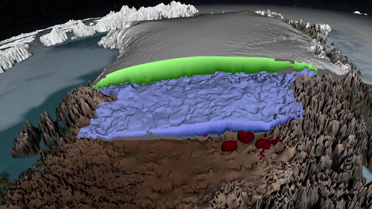
http://www.nasa.gov/content/goddard/icebridge/nasa-data-peers-into-green... Peering into the thousands of frozen layers inside Greenland’s ice sheet is like looking back in time. Each layer provides a record of not only snowfall and melting events, but what the Earth’s climate was like at the dawn of civilization, or during the last ice age, or during an ancient period of warmth similar to the one we are experiencing today. Using radar data from NASA’s Operation IceBridge, scientists have built the first-ever comprehensive map of the layers deep inside the ice sheet. This video is public domain and can be downloaded at: http://svs.gsfc.nasa.gov/goto?4249 Like our videos? Subscribe to NASA's Goddard Shorts HD podcast: http://svs.gsfc.nasa.gov/vis/iTunes/f0004_index.html Or find NASA Goddard Space Flight Center on facebook: http://www.facebook.com/NASA.GSFC Or find us on Twitter: http://twitter.com/NASAGoddard
-
 3:55:56
Due Dissidence
11 hours agoSchmuley TRASHES Shapiro, Maxwell Sings For Pardon, Uhuru Doc Preview - Live From St. Louis!
20.3K34 -
 LIVE
LIVE
Lofi Girl
2 years agolofi hip hop radio 📚 - beats to relax/study to
290 watching -
 LIVE
LIVE
PandaSub2000
5 days agoLIVE 9:30pm ET | MADISON VR (The Scariest Game Ever Made)
101 watching -
 2:34:32
Badlands Media
5 days agoCODEX 9/11
253K205 -
 1:53:43
Nerdrotic
6 hours ago $0.24 earnedMysteries of 3I/ATLAS | Forbidden Frontier #113
35.1K4 -
 2:04:21
vivafrei
1 day agoEp. 278: D.C. Peace Wave! Big Tish & Nipple Judge SPANKED! "Maryland Man" Trafficker FREE & MORE?
79.1K106 -
 LIVE
LIVE
Damysus Gaming
2 hours agoBorderlands 3 - Part 8 - FL4K Time | Children of the Vault be Warned!
51 watching -
 1:30:28
Patriots With Grit
5 hours agoWhat You Should Know About Harmful Vaccine Ingredients And What To Say To Your Doctor, Pediatrician, Health Department or School When They Pressure You, Your Kids Or Your Family Members | Dr. Bryan Ardis, D.C.
6.98K5 -
 LIVE
LIVE
This is the Ray Gaming
1 hour ago $0.01 earnedSunday Night Live with the Boys | Rumble Premium Creator
36 watching -
 2:02:16
ItsMossy
2 hours ago🍃NEW MIC WHO THIS🍃DRIVING SIM GO BRRR🍃420 SESH🍃
2.06K1