SWOT: Earth Science Satellite Will Help Communities Plan for a Better Futur
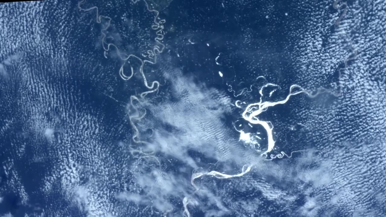
By examining the world's salt and freshwater bodies, a new Earth science mission led by NASA and the French space agency Centre National d'Études Spatiales (CNES) will assist communities in making better future plans. Lake, river, reservoir, and ocean water levels will all be measured as part of the Surface Water and Ocean Topography (SWOT) effort. As the water cycle quickens due to climate change, many towns may experience water shortages while others will experience water inundation. The U.S. Department of Defense, disaster preparedness organizations, colleges, water management organizations, civil engineers, and others who need to track water in their local locations will all benefit from the information that SWOT data will provide to improve flood forecasts and monitor drought conditions. In this video, experts from the National Weather Service in Oregon, the Alaska Department of Transportation, researchers from the Universities of Oregon and North Carolina, the NASA Jet Propulsion Laboratory working with the Department of Defense, and the Louisiana Coastal Protection and Restoration Agency share examples of how SWOT data will be used in these communities. Flood Watches and Warnings for Portland, Oregon, at 3:30 1:08 - Fern Ridge Lake, Oregon - Water Management 2:05 - Alaska Infrastructure Protection 2:54 - Department of Defense - National Security 3:24 - Mississippi River Delta Coastal Protection In December 2022, Vandenberg Space Force Base in California is anticipated to launch SWOT. The Canadian Space Agency and UK Space Agency have also contributed to the effort, which is a partnership between NASA and CNES. The U.S. portion of the project is led by JPL, which is run by Caltech in Pasadena, California, on behalf of NASA.
-

Barry Cunningham
5 hours agoPRESIDENT TRUMP IS STILL FLOODING THE ZONE! JUDGE JEANINE TAKES NO BS FROM MEDIA | IT'S MOVIE NIGHT!
36.2K35 -

megimu32
3 hours agoOTS: American Pie - Comedy Classic or Cancel Culture Casualty?
21.2K4 -
 LIVE
LIVE
SpartakusLIVE
4 hours agoDuos w/ @Rallied || #1 All-American Texas Farmboy turned HERO of Verdansk
377 watching -
 1:40:50
EricJohnPizzaArtist
3 hours agoSAUCY POSSE Kitchen Hangout and Chat!
18.7K -
 1:08:31
Nick Freitas
5 hours agoIs America Really back? America Awakened with Dr Turley
12.9K1 -
 9:24
9:24
Red Pill MMA
13 hours agoThe Truth About Ireland’s Homeless Crisis
12.8K8 -
 53:16
53:16
MattMorseTV
4 hours ago $7.64 earned🔴1.6 MILLION just DISAPPEARED.🔴
40.4K64 -
 3:14:08
Spartan
3 hours agoOMiT Spartan | Halo for a bit, Octopath after maybe
28.2K2 -
 1:21:56
Mally_Mouse
1 day agoLet's Play!! -- Toontown (Tuesday) Rewritten!
30.6K3 -
 LIVE
LIVE
LFA TV
23 hours agoLFA TV ALL DAY STREAM - TUESDAY 8/12/25
594 watching