NASA's Epic Reveal: Cracking the Code of Wildfires
2 years ago
11
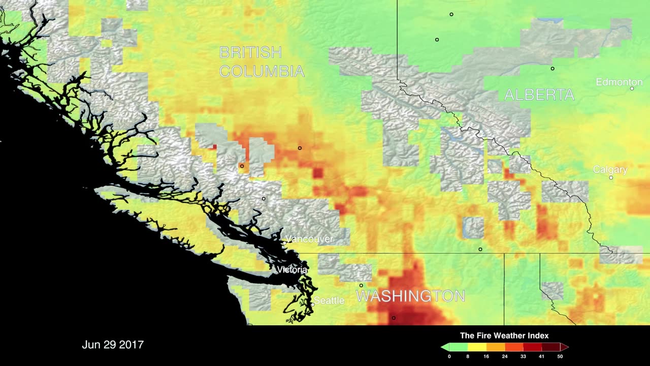
See how satellite data reveals the science behind the spread of destructive wildfires. This visualization from a space agency uses false-color imagery to map fuel types, temperature, and burn patterns. Learn how factors like wind, terrain, and drought conditions influence the dangers of forest fires. Gain insight into how remote sensing assists prediction and tracking of conflagrations. The stunning footage provides a unique perspective on these forces of nature and the impact on landscapes, wildlife, and human communities. Discover how cutting-edge observations from above are furthering wildfire research and response.
Credit: NASA's Goddard Space Flight Center
Loading comments...
-
 LIVE
LIVE
Lofi Girl
2 years agoSynthwave Radio 🌌 - beats to chill/game to
152 watching -
 2:33:04
Badlands Media
12 hours agoBaseless Conspiracies Ep. 147: Pole Shifts, Plasma Skies, and the Truth About Cataclysms
166K17 -
 4:33:42
Drew Hernandez
8 hours agoISRAEL BOMBS GAZA HOSPITAL ON LIVE TV KILLING AT LEAST 20 INCLUDING JOURNALISTS & CIVILIANS
20.8K42 -
 2:55:23
TimcastIRL
7 hours agoTrump Orders Specialized National Guard Units To Combat Crime In Cities, Dems Furious | Timcast IRL
205K142 -
 6:22:03
SpartakusLIVE
9 hours ago#1 Rocket CHAMPION of Verdansk wields UNSTOPPABLE new META
81.3K5 -
 2:55:11
Barry Cunningham
9 hours agoPRESIDENT TRUMP MADE TODAY A VERY BAD DAY TO BE A DEMOCRAT!
100K63 -
 1:15:29
Flyover Conservatives
1 day agoFrom Cool to Cringe: How Democrats Lost America’s Ear | FOC Show
48.1K14 -
 8:19
8:19
MattMorseTV
12 hours ago $7.72 earnedTrump is ACTUALLY DOING IT.
48.5K41 -
 11:30:43
ZWOGs
15 hours ago🔴LIVE IN 1440p! - Tarkov w/ Casey & crgoodw1n, Kingdom Come Deliverance, & More - Come Hang Out!
40.6K5 -
 2:30:56
We Like Shooting
19 hours ago $8.72 earnedWe Like Shooting 625 (Gun Podcast)
40.3K1