Abandoned Section of the Canyon Road, Return Visit
Finally returned to check out the this puzzling section of the Canyon Trail just below Gold Mine Creek in the Montebello Open Space Preserve.
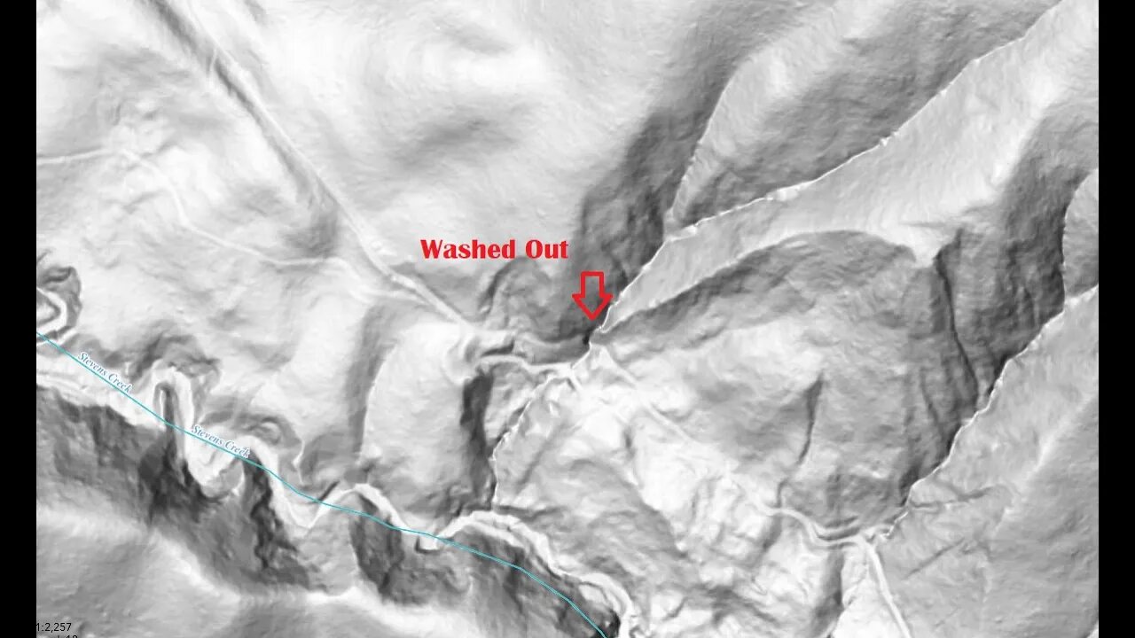
It appears the small creek that this road crossed here must have had some major flooding and took out a large section of road. Since the ranches in this area seemed to have stopped active operations, whoever built this road probably didn't feel the need to repair it after it washed out.
I've ridden by this part of the Canyon Trail countless times and always wondered why it's different than the rest of the trail. This is located just down from mile post 2.5.
The Canyon Trail shows up down to this location on the 1961 USGS historical topo map, marked as a "Jeep Trail". On that map, it ends right at this point, where it turns into a somewhat modern multi-use trail for about 1/4 mile. Then it turns back into an old single lane dirt road all the way down to where it crosses Stevens Creek at the Lower Table Mountain trail.
When the Open Space District took over in the 1970s, they likely wanted to connect the 2 sections of the Canyon Trail back up to access the lower half of the canyon. So a multi-use trail was built around the washed out section of the old road. This may have been around 1990 or earlier as there was some trail construction below here around that time.
An accurate hill shade map proved to be invaluable in locating the old road, especially at the lower end. Since there's no cell coverage in the canyon, having an off-line version of that map is essential.
USGS National Map Viewer w/ Hill Shade:
https://apps.nationalmap.gov/viewer/
About the USGS HTMC:
https://www.usgs.gov/programs/national-geospatial-program/historical-topographic-maps-preserving-past
View/download maps on the TopoView site:
https://ngmdb.usgs.gov/topoview/
Montebello Open Space history page:
https://www.openspace.org/preserves/monte-bello#history
More to come...
Subscribe for more content like this
Comment, rate, share & click the bell icon
And as always, thanks for watching
#USGS #HillShade
-
 1:32
1:32
Gaming on Rumble
11 hours agoWhat is the Rumble Creator Program?!?! | Lvl UP
21.9K4 -

Flyover Conservatives
23 hours ago9/11 on Steroids: What’s Coming This Fall? - Bo Polny | FOC Show
28.8K3 -
 1:01:28
Precision Rifle Network
8 hours agoS4E27 Guns & Grub - Let's Talk About Gas Guns
15K1 -
 59:29
59:29
The Charlie Kirk Show
4 hours agoTHOUGHTCRIME Ep. 96 — The Great Flag Burning Debate
42.1K34 -
 57:56
57:56
The Mel K Show
4 hours agoMel K & General Mike Flynn | Betrayal of a Nation: Soros’ NATO World Order | 8-28-25
26.3K26 -
 2:13:31
Joker Effect
3 hours agoInterviewing BEN JAMMINS! A personality with over 1 BILLION gif views. Let's give him a warm welcome
13.2K1 -
 11:37
11:37
Robbi On The Record
9 hours agoThe Devil is in the Branding..
14.5K9 -
 1:26:44
Savanah Hernandez
5 hours agoWhy Gen-Z Is So Radicalized Against Immigration
13.4K6 -
 2:36:19
megimu32
4 hours agoOTS: From A-List to MIA! 90s & 2000s Stars Who Vanished
8.85K3 -
 4:18:29
TinyPandaface
4 hours agoYour FACE Is A Gaming Channel! | Clue Classic w/ THE FELLAS!
5.96K2