Master the Digitizing in 15 Minutes _ ArcGIS In-Depth Tutorial 1
2 years ago
52
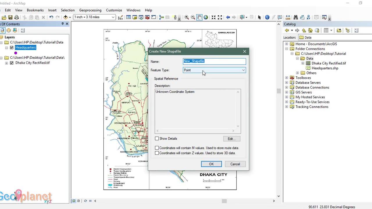
Welcome to the comprehensive and hands-on course, "Mastering the Digitizing in ArcGIS." Whether you're a GIS enthusiast, a seasoned professional, or a student exploring the world of Geographic Information Systems, this course is designed to take your mapping and data capture skills to new heights.
ArcGIS, developed by Esri, is one of the most powerful and widely-used GIS software packages available today. Its digitizing capabilities enable users to create, update, and maintain spatial data with unparalleled precision. In this course, we will dive deep into the art and science of digitizing, equipping you with the knowledge and expertise to produce accurate and reliable digital representations of the real world.
Loading comments...
-
 23:22
23:22
Stephen Gardner
1 day ago🚨BREAKING: Mamdani Won and What Trump EXPOSES About It is SHOCKING!!
49.6K140 -
 1:16:41
Steve-O's Wild Ride! Podcast
21 hours ago $0.06 earnedAdam Ray Absolutely Kills Steve-O | Wild Ride #273
39K5 -
 37:22
37:22
efenigson
1 day agoWhat COVID Taught Me About Money & Control - Efrat Fenigson | Ep. 104
30.9K4 -
 1:20:56
Dialogue works
2 days ago $0.58 earnedCol. Larry Wilkerson: No Way Out for Israel - Iran & Russia — NATO’s Worst Fear
57.1K14 -
 10:37
10:37
TheSaltyCracker
20 hours agoMassive Brawl Breaks Out in Bass Pro Shop Over Bathroom
63.9K165 -
 16:40
16:40
Actual Justice Warrior
17 hours agoSydney Sweeney REFUSES To Apologize For Being White
43.4K52 -
 1:57:23
MG Show
23 hours agoTrump Makes Announcement; Erika Kirk 1st Interview
42.4K48 -
 8:01
8:01
MattMorseTV
16 hours ago $0.85 earnedTrump just GUTTED the ENTIRE SYSTEM.
87.7K116 -
 20:02
20:02
Nikko Ortiz
16 hours agoBlades And Sorcery Is The Ultimate Medieval Fantasy
25.7K6 -
 2:12:18
Side Scrollers Podcast
1 day agoSide Scrollers VTuber TAKE OVER with Kirsche, Rev Says Desu & DarlingStrawb | Side Scrollers
106K19