Drone Captures Slackliner's Incredible Valley Crossing
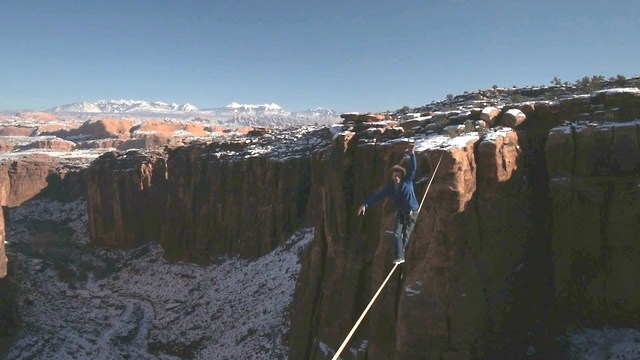
The Moab desert forms a breathtaking backdrop to a slack liner's nail-biting valley crossing 400ft in the air.
Using a camera attached to a drone, a team from SkySight Aerial Imaging was able to film the daredevil walk in 360 degrees. Thrill-seekers Andy Lewis and Scott Roger scaled towering rock monuments to make the 70ft crossing - and were treated to unparalleled aerial views of the snowcapped Utah landscape.
The Biblical name Moab refers to an area of land located on the eastern side of the Jordan River. Some historians believe the city in Utah came to use this name because of William Pierce, the first postmaster, believing that the biblical Moab and this part of Utah were both "the far country". However, others believe the name has Paiute origins, referring to the word moapa, meaning "mosquito".
Moab is famous for canyoneering, hiking, river rafting, biking, motorcycling, ATV riding, and 4x4 driving. The Moab area is home to many easy to difficult off-road trails for novice to experienced off-roaders. Every year the Moab Munifest, one of the biggest mountain unicycling events in the world, takes place at Moab.
What a stunning view!
-
 46:12
46:12
Candace Show Podcast
3 hours agoBrigitte Presents “Proof” Her Brother Is Alive. | Candace Ep 221
42.7K134 -
 LIVE
LIVE
Quite Frankly
6 hours ago"American Eagle Rage Bait, Pay The WNBA?, Calls & More" 7/29/25
554 watching -
 9:11
9:11
China Uncensored
9 hours agoChina Riots! Communism FAILED Yet Again.
1.56K4 -
 LIVE
LIVE
Robert Gouveia
2 hours ago'Missing Minute' is GONE! New IMMUNITY Demands! Obama's PLOT! Schiff in TROUBLE!
788 watching -
 11:35
11:35
Tactical Advisor
2 days agoAnother Sig Trigger Fail | P320 P365 and X Macro
12.3K5 -
 7:34
7:34
Michael Button
9 hours ago $0.19 earnedWhy I Left Academia to Explore Lost Civilizations
3.71K2 -
 1:01:58
Sarah Westall
2 hours agoNEW STUDY RESULTS: Humans have MAC ID Chips – How Did They Get There? w/ Hazen and Mansfield
10.7K7 -
 54:45
54:45
BlendrNews
2 days agoLegacy Media is Going Extinct with Sam Anthony (YourNews) | Blendr Report EP116
1342 -
 30:00
30:00
BEK TV
21 hours agoCounter Culture Mom
1.08K -
 2:03:53
Pop Culture Crisis
5 hours agoBillie Eilish & Sydney Sweeney Blamed For 'Whiteness', Millennials WORRIED About Gen Z | Ep. 887
30.7K12