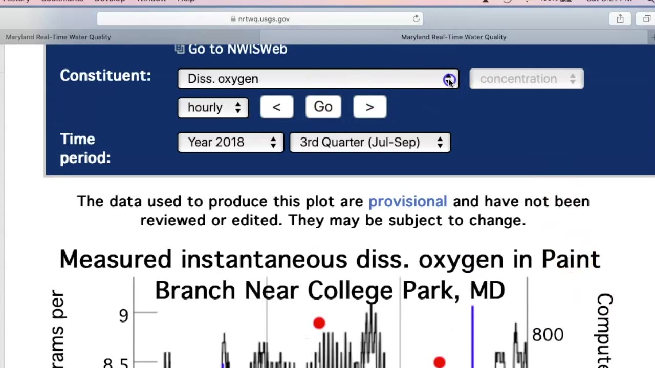
Analyzing Water Quality Data from the US Geological Survey
Here is the direct link to the USGS:
Here is the direct link for the data in MD:
waterdata.usgs.gov/md/nwis/dv?referred_module=qw&county_cd=24001&county_cd=24
003&county_cd=24005&county_cd=24009&county_cd=24011&county_cd=24013&county_cd
=24015&county_cd=24017&county_cd=24019&county_cd=24021&county_cd=24023&county
_cd=24025&county_cd=24027&county_cd=24029&county_cd=24031&county_cd=24033&cou
nty_cd=24035&county_cd=24037&county_cd=24039&county_cd=24041&county_cd=24043&
county_cd=24045&county_cd=24047&county_cd=24510&site_tp_cd=OC&site_tp_cd=OCCO&site_tp_cd=ST&site_tp_cd=ST-CA&site_tp_cd=ST-DCH&site_tp_cd=STTS&index_pmcode_00300=1&group_key=NONE&sitefile_output_format=html_table&column
_name=agency_cd&column_name=site_no&column_name=station_nm&range_selection=date_r
ange&begin_date=2010-04-04&end_date=2020-04-02&format=gif&date_format=YYYY-MMDD&rdb_compression=file&list_of_search_criteria=county_cd%2Csite_tp_cd%2Crealtime_par
ameter_selection
This link provides a map of land use in MD:
-
 0:54
0:54
Gaming on Rumble
6 hours agoRumble Premium x Preplexity Pro Subscription Bundle
2.26K1 -
 LIVE
LIVE
LFA TV
1 day agoLIVE & BREAKING NEWS! | MONDAY 11/17/25
523 watching -
 LIVE
LIVE
Sen D Regon
1 hour agoExophobia Ep1 | Shoot'en Me Some Space Aliens
29 watching -
 LIVE
LIVE
JDubGameN
2 hours agoArc Raiders | Road to 100 Followers | DubNation LIVE
28 watching -
 LIVE
LIVE
The Jimmy Dore Show
2 hours agoWill Trump’s Attacks on Massie & MTG KILL MAGA? Candace SILENCES Zionist CNN Reporter! w/ Kim Bright
6,533 watching -
 LIVE
LIVE
AUXgaming
2 hours ago👽 Charles and Lewis need to give the BIRD to their Boss! 👽 #1 ALIEN ON RUMBLE 👽 POSITIVE VIBES! 👽
26 watching -
 53:42
53:42
The White House
9 hours agoPresident Trump Delivers Remarks at McDonald's Impact Summit
18.9K18 -
 44:39
44:39
Donald Trump Jr.
3 hours agoBuilders vs Bureaucrats, LIVE News Coverage | TRIGGERED Ep.292
87.9K68 -
 15:55
15:55
T-SPLY
9 hours agoFederal Agents Almost Hit By Fleeing Suspect - Charlotte Clash!
12.9K9 -
 1:12:29
Kim Iversen
4 hours agoTrump Suddenly BEGS for the Epstein Files to Drop | Oxford Union: Israel Is A Bigger Threat Than Iran
101K167