
Spring Lake HWY 24 to HWY 210
I have been wanting to explore the Lower Little River all the way to Cape Fear River, scouting the area on both sides of the river to look for put-in and take-out locations, I am looking to paddle entire length in very near future and do an overnight camping trip, so scouting and exploring the possibilities of such has been on my mind for sometime and I have been reading trip reports ofr other paddlers and also picking their brains, or what is left of them. Today was such another trip, I met up with a brave soul, Garett 0900 hrs this morning we off loaded the boats to the put-in, and one of the ladies from the from the church pulled up, I spoke with her, it seems I will be attending her church this Sunday. She gave permission to use the area for access, the put-in was a nice sand bar beach, so not issues there. I decided because of the raian we should check the conditions of the possible take outs, so Garett and I checked them out all the way to the main take I wanted to use. The take-out was a different matter, so we tied a rope to tree and attached a tow line for us to grab, this served 2 purposes, one to mark the area and two to grab to get out, there are actually 2 location within a few yards of each other, we used both at end of the trip. the take out location was just a mess of litter and trash, it appears that this was used as a dump and homeless area, an 8 man tent was at location and was in disrepair. We traveled back and unlaoded the rest of gear and boat and Garett shuttled me back to my truck. The weather was very nice and I actually was glad I had shorts on.
The trip was 3 miles, we did it in 45 minutes, the water was moving that fast, the area had been cleared as there was signs of clearing it in last couple of years, of note there are also distance markers on the way down the river. The banks are steep, so if you spill over, there is no bank to swim to, you will have to do a in water rescue, there was some downfall , but nothing of any concern, but may be in lower water at the USGS Manchester at the 6ft level,.
Really this is my kind of paddling, steep banks, no litter and fast moving water in a narrow river.
USGS Gauge Manchester level 9.08ft at 552cfs
-
 1:21:31
Man in America
10 hours agoTech CEO Exposes the Diabolical Plan to ENSLAVE Us Through Smartphones
33.3K19 -
 9:53
9:53
MattMorseTV
13 hours ago $8.09 earnedCNN just made a FATAL MISTAKE.
30.2K27 -
 3:38:20
Alex Zedra
4 hours agoLIVE! Playing CoD
16.6K2 -
 15:23
15:23
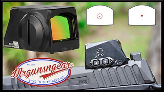
Mrgunsngear
13 hours ago $4.17 earnedSig Sauer Enclosed Sig Loc Romeo-X Compact Red Dot Torture Test & Review
40.9K4 -
 3:05:54
Mally_Mouse
10 hours agoThrowback Thursday! Let's Play: Epic Mickey (Part 7 - final Good Ending)
19.2K3 -
 9:51:29
RalliedLIVE
12 hours ago $9.77 earnedSHOTTY BOYS VS WARZONE
143K1 -
 1:30:28
AimControllers
5 hours ago $4.09 earnedTRIVIA NIGHT!! WIN CUSTOM CONTROLLERS!!
53.6K3 -
 4:15:33
Barry Cunningham
6 hours agoWELCOME TO THE FANFARE MOVIE NIGHT! YOU WON'T WANT TO MISS THIS INTERVIEW AND FILM!
110K35 -
 2:20:27
PandaSub2000
1 day agoAnticipation | PHOENIX & HAVIX (Original Live Version)
28.7K5 -
 2:00:59
megimu32
5 hours agoON THE SUBJECT: The Villains We Loved to Hate - Childhood Trauma Reloaded
25.8K2