Stevens Canyon Land Slide, Tectonic Block?, Part 2
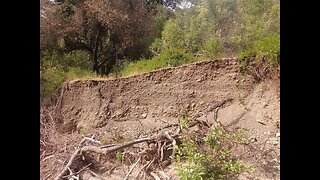
A return visit to the bottom of the landslide area below Stevens Canyon Road / Canyon Trail.
The week before, I ventured into the depression between the canyon slope and the ridge above the landslide. This time, I wanted to return to the base of the block along the creek. This is where this block is in contact with the rocks of the North American plate. There seems to be a section of weak rock along the NE side of the canyon and this tectonic block is pushing into that, forcing the creek to erode into that side of the canyon. Over time, that steepens the slope until an earthquake triggers a massive landslide.
Paper: ENVIRONMENTAL GEOLOGIC ANALYSIS OF THE MONTEBELLO RIDGE MOUNTAIN STUDY AREA:
https://openlibrary.org/works/OL68916...
Pg. 22 mentions a landslide associated with the 1906 earthquake and this is ground zero for that slide. In fact, the report mentions that slide extended for 1/2 mile, nearly a kilometer, along the canyon.
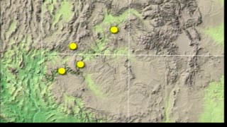
USGS National Map Viewer w/ Hill Shade layers:
https://apps.nationalmap.gov/viewer/
More to come...
Subscribe for more content like this
Comment, rate, share & click the bell icon
And as always, thanks for watching
#USGS #HillShade #geology #earthquake #tectonicplates
-
 16:38
16:38
4Crawler
1 year agoStevens Canyon Land Slide, Tectonic Block?, Part 1
3 -
 4:25
4:25
4Crawler
1 year agoStevens Creek Landslide Lake Deposit Layers
11 -
 1:02:32
archektisis
3 years ago $0.17 earnedCreation Seminar Part 2, Mike Snavely: The Grand Canyon
398 -
 3:42
3:42
Worldnewsreporttoday
1 year ago $0.07 earnedThe Biggest Secret In America! The Walker Lane Fault Zone!
3872 -
 47:30
47:30
Hydroplate Conference
8 months agoGrand Canyon Answers
2331 -
 19:04
19:04
Scenic Mt Shasta
1 year agoHole and shallow cavity in Lava flow - Medicine Lake Highlands Volcanic Area - Scenic Mt Shasta
35 -
 13:32
13:32
A little bit of everything!
4 years ago2020 Elephant Butte, NM Trip - Chloride Canyon - Part 1
57 -
 18:05
18:05
Cactus Hill
1 year agoUpper Muley Twist Canyon Trail in Capitol Reef National Park
12 -
 1:46:55
repairmanscully
3 months agoUnderground Science #395 - The Rocky Mountain Trench
2 -
 17:40
17:40
GeologyForestryEngineering
2 years agoAlpine Loop Country Road 10 Out of Silverton Colorado July 21, 2021 Part 2
20