Old Maps 1720 Pre United States of Tartarian and California Island Red Hair Giants
Old Maps Pre United Stated B.C. (pre-before Columbus), will take us on a tour of pre America and the old United States. We will also explore star forts in America, old town Checagou later-Chicago, craters in the Carolinas, the noble ancient cities of the great Salt Lake, the seafaring red headed people nevada coastline indigenous tribes and the bermuda triangle area.
So Pre-Nevada Seafaring Red Hair Native American tribes/civilizations ? Red-haired Giant Cannibals at Lovelock Cave? Really? Nevada Coastline Pre 1720 ? Hey, thanks for the great question. First, I'd like to point out that the use of canoes, and in some cases relatively large boats, by the Haida, Inuit, Mi'kmaq and many others for military and fishing purposes originated in their respective coastal and sea/river-faring cultures adapting to their immediate needs. As others have also noted, Native American cultures with deep and historic maritime traditions continue to thrive all along the Arctic and Pacific North West coasts.
Despite this, however, the disparity in technology you mention can be explained in simple terms. It can be noted that many notable maritime and naval developments in the Old World were driven by the direct competition of rival and neighboring states. This constant naval arms race, particularly in the Mediterranean and across the English Channel, is a key factor (in my opinion) explaining the disparity you noted.
This lack of an immediate, direct and constant maritime threat may have contributed to the limited nature of their maritime needs. Basically, naval technology and advancements didn't develop to the extent of, and parallel to, the Old World because the (primarily) defensive and economic needs were different.
This theory of need-driven maritime advancements can also explain how other cultures sharing conditions similar to Native Americans - namely Polynesian and Melanesian - were also able to become expert navigators on the ocean.
Adding to that, unlike in North America, the conditions were also there during the earlier Classical era, and later the Islamic Golden Age followed by the Renaissance, for major scientific breakthroughs in navigation, astronomy and shipbuilding.
Edit: Forgot to add that many Old World powers maintained vast, international maritime trade networks, and later colonial holdings. These inevitably required the development of maritime capabilities and comprehensive naval doctrines that drove naval advancements forward.
Colorful tales of the American West don’t fade away easily, even when they seem to have been discounted. Take, for example, the story of legendary red-haired cannibal giants whose alleged existence in the Lovelock area centuries ago has been debated for more than 100 years. Scientists have said there’s no proof the “giants,” first described in old Indian tales, were cannibals. Chemical staining by earth after burial was advanced as a likely reason why mummified remains have red hair instead of black like most Indians in the area.
Native American Tribes Map: Indigenous Peoples USA The map above shows how indigenous American tribes were distributed throughout North America and parts of the Caribbean.
These indigenous peoples (IPs), with 86 tribes in total, are spread in 11 regions throughout the continent.
The Eskimo is the sole tribe in the Arctic region, located in the extreme north of present-day Canada and the Danish province of Greenland.
Two indigenous groups occupy the Subarctic region that comprises most of north-central Canada:
Yellowknife - Chippewyah
Eight IP groups live in the Northwest Coast region:
Tlingit - Haida - Kwakiutl - Salish - Nootka - Makah - Chinook - Tillamook
In the California region live seven tribes:
Yorok - Hupa - Maiou - Yuki - Pomo - Miwok - Mono
Five ethnic groups inhabit the Plateau area:
Spokane - Coeur d’Alene - Cayuse - Nez Perce - Flathead
There are also five IP groups living in the Great Basin area:
Modoc - Shoshoni - Washo - Paiute - Ute
The Southwest region houses ten groups:
Navajo - Apache - Hopi - Zuñi - Mohave - Yuma - Pima - Papago - Pueblo - Karankara
In the region of Mesoamerica live three ethnic tribes:
Aztec - Ciboney - Taino
There are 16 tribes living in the Great Plains region:
Cree - Crow - Mandan - Arikara - Sioux - Iowa - Missouri - Arapaho - Kansa - Osage - Cheyenne - Quapaw - Kiowa - Apache - Comanche - Waco
In the Northeast region live the most number of indigenous tribes, 19 to be exact:
Ojibwa - Huron - Menomini Ojibwa - Saux Fox - Iroquis - Massachuset - Kickapoo - Potawatomi - Illinois - Miami - Erie - Pamunkey - Susquehanna - Delaware - Powhatan - Shawnee - Chickahominy - Tuscarora - Catawba
Finally, in the Southeast region live 11 indigenous American tribes:
Cherokee - Tuskegee - Creek - Chickasaw - Choctaw - Wichita - Caddo - Natchez - Alabama - Timukua - Calusa
In this Reddit thread, several users notice that since the map is sourced from a textbook published in the United States (US), there are more tribes situated in the modern-day US. This means that other nations such as Canada and Mexico are underrepresented, and only have a few tribes listed on the map.
A University of Nevada study in the mid-1970s indicated the “giants” were about six feet tall, and not up to 10 feet tall as had been claimed. What was left after that was evidence of a tribe separate from principal tribes whose Paiute descendants live here — perhaps a wandering, more aggressive but outnumbered band finally hunted down and killed or chased off.
Anthropologists say the story, while somewhat tamer, is still fascinating. But they concede the old myth has more appeal and, no matter what they say, will probably persist.
The mid-1970s study was conducted after a bundle of bones, marked “giant bones,” were found in a long-overlooked cabinet at the Nevada Historical Society building in Reno.
The late Sheilagh Brooks, who chaired the anthropology department at UN-Las Vegas, analyzed the bones which apparently came from the Lovelock Cave, a treasure trove for scientists trying to reconstruct Nevada’s early history.
Dr. Brooks said her investigation showed that some of the bones were from cows, not giants. The human bones appeared to be remains of Indians “maybe six feet tall — big, but not that big,” she said. The myth was written down in 1883 by Sarah Winnemucca Hopkins, daughter of a Paiute Indian chief. She told of a strange, red-haired tribe of cannibals her ancestors drove into a cave and suffocated by lighting a fire at its entrance.
She said the “people eaters” were so fierce they would leap into the air, snatch arrows whizzing over their heads, and shoot them back at their enemies. The Paiutes named the giants Si-Te-Cah, which translates to tule-eaters. The giants wove tules, a fibrous water plant, into rafts to navigate across what remained of Lake Lahontan, so the story goes.
The Paiutes, a Native-American tribe indigenous to parts of Nevada, Utah and Arizona, described the Si-Te-Cah as a vicious, unapproachable people that killed and ate their captives, and told early settlers that after years of warfare all the tribes in the area joined together to rid themselves of the giants.
The fleeing giants took refuge in Lovelock Cave and refused to leave despite demands that they come out and fight. So their pursuers filled the entrance to the cave with brush that was set on fire in a bid to force the giants to come out. The few that did emerge were promptly killed. The giants that remained inside the cavern were asphyxiated.
John T. Reid, a Lovelock mining engineer, said Indians took him to the cave in 1886 and told him the tale of the red-haired cannibal giants. But when he entered the cave he found nothing but tons of bat guano. Reid was unsuccessful in getting an archaeological dig started immediately. But miners, realizing the value of guano as fertilizer, started hauling it out in 1911. They promptly turned up bones, baskets, weapons, tools, duck decoys, various other artifacts and what they described as a 6-foot-6 mummy. James H. Hart, one of the miners, wrote that the mummy, found in the north-central part of the cave about four feet down, had hair that was “distinctly red.”
The discovery spurred an archaeological dig in 1912, followed by a second dig in 1924. Thousands of artifacts and about 60 average-height mummies were recovered. Not all the mummies were preserved. One of the best specimens reportedly was boiled and destroyed by a local fraternal lodge that wanted a skeleton for initiation purposes. More studies followed, including radio-carbon dating that showed the cave was occupied from about 2,000 BC to about 900 AD. Adrienne Mayor wrote about the Si-Te-Cah in her book, “Legends of the First Americans.” She suggested that the ‘giant’ interpretation of the skeletons from Lovelock Cave and other caves in Nevada was started by entrepreneurs setting up tourist displays. She also noted that hair pigment is not stable after death and that various factors such as temperature and soil conditions can turn very dark hair rusty red or orange. All that may be so. But try convincing readers who love a good tall tale.
Basically every culture had watercraft of some sort. One that spring to mind that haven't been mentioned already are the Chumash boats, the tomol. They could go deep sea fishing for big sports fish like marlin in those. Also the Inca were more seafaring than people give them credit for. They visited the Galapagos for example, but didn't stay because there aren't any permanent fresh water sources.
I also think there really is something to say about the "they never needed to be seafaring so they weren't" perspective. The Americas are incredibly rich in natural resources. For example, many Californians and northern-coast peoples never adopted agriculture even when their neighbors did because the coastline is just so rich in food. In addition, American agricultural practices tended to be much more sustainable ecologically than European or Asian ones, from the Andean terraces to Mesoamerican milpas and the pervasive Three Sisters method. Remember, European seafaring was primarily motivated by the need for more efficient trade or to secure access to resources. This same pressure simply didn't affect Native peoples -there simply wasn't the need to mobilize the resources and manpower for these types of operations. In addition, there were already efficient trade routes (look up the Aztec trading empire or the famous Incan chasquis for instance) and hunger was extremely rare. So why bother paying for a voyage off into the horizon likely to your death?
The natives in the Caribbean had a robust dugout canoe culture, and Europeans remarked on the skill and proficiency of the natives at the time of contact.
Because of the slower spread of people across the vast space of North and South America, people didn't show up in the Caribbean until around 6,000 years ago; the Taino / Arawak people showed up around 2500 years ago.
What the Americas do not have is a densely islanded area with valuable trade that spurs additional maritime development and also allows the easy transfer of technology.
Europe had the Mediterranean in general - much smaller and calmer than the oceans - and the Aegean specifically. The many small islands required more trade due to the limitations of goods on some of the islands, and also the discovery of metal deposits on some of the islands (especially copper on Cyprus). The Phonecians were instrumental in coming up with better sailing techniques in the Mediterranean and spreading it around.
In Asia, the many islands of Indonesia that are easily visible from the mainland, plus the very large population carrying capacity and arise of different civilizations in India and China helped spur development and trade. The Austronesian people developed the first real ocean-going vessels with outriggers and sails, and then quickly started establishing trade routes into South Asia and the Arabian sea, spreading these ideas of better ship building and the use of sails.
Given that the settlement of the Americas happened at least several thousand years later than the areas around the Levant or SE Asia (potentially Taiwan, where the austronesian expansion is predominately believed to start), it's not unusual that one of the peoples there didn't spark a similar revolution just yet.
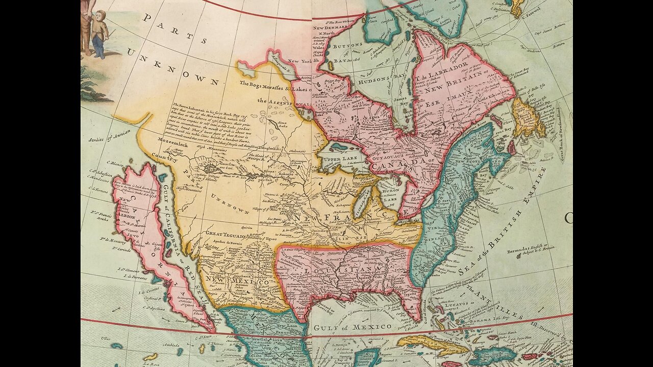
Map of North America [Codfish map], 1720
https://www.reddit.com/r/oldmaps/comments/6x0g83/map_of_north_america_codfish_map_1720/
-
 20:34
20:34
What If Everything You Were Taught Was A Lie?
17 days agoSo How Mass Idiocracy Today Came To Be The Real Cost Of The Disappearance Of Personal Wisdom
2.24K3 -
 36:41
36:41
Stephen Gardner
2 hours ago🔥BREAKING: Trump-Epstein Saga Gets CRAZIER—Must-See New Evidence Revealed!
15.2K27 -
 43:25
43:25
Michael Franzese
2 hours agoThis Is the Most Important Thing I’ll Ever Say
24.1K22 -
 LIVE
LIVE
Robert Gouveia
1 hour agoCongress HAMMERS Epstein Files! Maxwell APPEAL Decision! Obama Suspects LAWYER UP! 14th Amendment!
1,475 watching -
 2:44:28
Barry Cunningham
4 hours agoPRESIDENT TRUMP TOURS JEROME POWELL SCENE OF THE CRIME AT THE FEDERAL RESERVE
30K9 -
 1:25:14
Sarah Westall
3 hours agoBlackmail, Power & Corruption: The Currency of the Empire - Epstein & more w/ Joachim Hagopian
20.4K6 -
 16:33
16:33
Clownfish TV
8 hours agoLate Night TV Has NO FUTURE After Stephen Colbert's Cancellation!
4K8 -
 45:56
45:56
The White House
3 hours agoPresident Trump Visits the Federal Reserve
31.6K20 -
 36:14
36:14
Kimberly Guilfoyle
4 hours agoRussia Hoax Reality Check, Live! | Ep240
29.4K10 -
 11:02
11:02
Preston Stewart
8 hours ago $0.61 earnedThailand–Cambodia Clash Erupts
10.5K3