Off-Line Hill Shade Maps: How To, Part 3
STEP 3: Uplooading the DIY hill shade map to your mobile device.
I find the DSFile app on my Synology NAS is a great way to upload map files for use in OsmAnd. The first time you click on an sqlitedb file, select "Document Formats" as the file type. At that point, you'll be prompted for what app to use for that file type. Scroll down and select OsmAnd and that file will get uploaded to the OsmAnd map folder and the app will be launched.
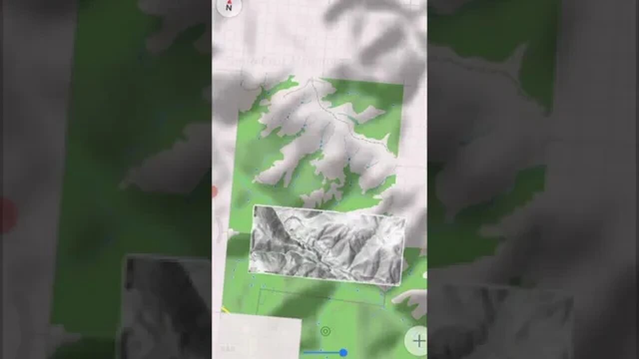
It's a good idea to check out your new hill shade map by selecting it as the Overlay map then compare how features on it line up to the off-line vector base map.
It seems that using Zoom Level 17 in the USGS map viewer is a good match for this process, as it results in a 1 meter/pixel resolution in the OsmAnd raster map that matches the resolution of the hill shade data. I didn't know that earlier and had been using Zoom Level 18. With OsmAnd, you can zoom into the hill shade map to see smaller details.
OsmAnd (IOS and Android) - Create Offline Raster & Vector Maps:
https://osmand.net/docs/technical/map-creation/create-offline-maps-yourself
DSFile app:
https://kb.synology.com/en-global/DSM/help/DSfile/Android?version=7
This app only supports portrait mode, thus the vertical format on the video.
Mapc2Mapc (Windows only):
https://www.the-thorns.org.uk/mapping/
USGS National Map Viewer w/ Hill Shade layers:
https://apps.nationalmap.gov/viewer/
If you're looking for hill shade maps of Washington State, use the Washington DNR Lidar Portal instead:
https://lidarportal.dnr.wa.gov/
Awesome resource. If you know any other states that offer similar tools, post up in the comment section below. I've looked for one for California and found nothing of use.
More to come, moving the map to your mobile device...
Subscribe for more content like this
Comment, rate, share & click the bell icon
And as always, thanks for watching
#USGS #HillShade #osmand
-
 LIVE
LIVE
Wendy Bell Radio
5 hours agoTaking Out The Trash
7,925 watching -
 10:45
10:45
NewsTreason
12 hours agoHealth Spotlight: Krill Oil vs Fish Oil with Dr. Chad Walding, Co-founder, NativePath
5.48K6 -
 7:07
7:07
SpartakusLIVE
43 minutes agoHacker BANNED LIVE in streamer match
-
 1:07:00
Chad Prather
22 hours agoFinding Peace, Purpose, and Power in a Hostile Age
59.2K21 -
 LIVE
LIVE
LFA TV
13 hours agoLIVE & BREAKING NEWS! | MONDAY 10/27/25
2,795 watching -
 1:24:46
Game On!
17 hours ago $4.18 earned2025 Sports Equinox Betting Preview!
20K2 -
 32:51
32:51
The Why Files
3 days agoCIA Time Travel Secret | The Grays Are Future Humans
32.1K44 -
 30:13
30:13
Athlete & Artist Show
22 hours ago $6.47 earnedNew Single Game Shots Record!
33.6K4 -
 13:29
13:29
Demons Row
14 hours ago $3.11 earnedThings I Wish I Knew Before Joining a 1% Outlaw Motorcycle Club
17.8K10 -
 22:24
22:24
Jasmin Laine
18 hours agoTrump SLAMS Canada As “Land of PROPAGANDA and Economic COLLAPSE!”
20.8K48