Satellites Are Saving Lives In Battle Against Chile's Wildfires
Satellites are saving lives in Chile where wildfires caused by record-hot weather are breaking out in the Southern Hemisphere.
Summer temperatures in the Southern Hemisphere of more than 104 degrees Fahrenheit (40 degrees Celsius) are affecting attempts to combat a massive wildfire outbreak involving at least 231 distinct flames in central Chile.
At least 26 people have been killed, 1,182 have been wounded, 1,100 dwellings have been demolished, and three regions have declared a state of emergency.
These wildfires are burning in three sparsely inhabited central districts - Araucana, Biobo, and Nuble - which are home to many grape, apple, and berry farms, as well as large areas of forest land.
The Nuble area has maintained a preventative early warning system owing to the possibility of forest fires caused by high temperatures since 30th January.
The flames are occurring in the midst of a 13-year-long drought and an extraordinary heat wave in the country's south.
The wildfires have already made 2023 the second worst year in terms of hectares burned, following the so-called "firestorm" that ravaged the nation in 2017.
Twenty-eight of the hundreds of fires have burnt the amount of forest and woodland that the country normally loses in a year.
Temperature forecasts from Santiago to the southern areas have sparked worries about the existing 81 active flames.
Authorities have warned that continued hot and dry weather might aggravate what are already the worst fires in the country's recent history.
Carolina Toha, Chile's interior minister, claimed 76 new flames erupted on 3rd February alone, and that record temperatures were making it impossible to contain the blazes.
"The temperature has reached levels we've never known before," Toha remarked on Saturday.
She also urged that the flames act as a wake-up call to the consequences of the climate disaster. "Chile is one of the countries most vulnerable to climate change, and this is based on genuine experience, not theory."
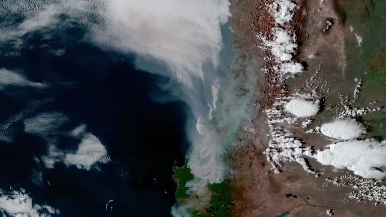
In a dynamic fire environment, NOAA's geostationary satellites offer immediate and potentially life-saving information.
Fires are regularly detected by GOES-16 and GOES-18 before they are seen on the ground, which is especially crucial in isolated places.
The satellites also detect fires in real-time, identify and track smoke, and assist in determining the magnitude and temperature of a fire.
The NOAA-20 and Suomi NPP polar satellites of the Joint Polar Satellite System serve a significant role in identifying and tracking wildfires, particularly in remote areas.
Their high spatial resolution imager identifies smaller, lower-temperature flames and also detects fires at night.
These satellites' data is also crucial for smoke models used by fire departments, first responders, and air traffic controllers.
-
 0:58
0:58
Viral Tab News
2 years ago $0.04 earnedDrug Trafficker Seized In Spain After Decade Under Radar
623 -
 LIVE
LIVE
Badlands Media
18 hours agoAltered State S3 Ep. 34
2,536 watching -
 LIVE
LIVE
RalliedLIVE
5 hours ago $0.81 earnedSpecialist Addicted Man Plays Warzone
71 watching -
 8:38
8:38
WhaddoYouMeme
5 hours agoChristians in Iran Are Being Hunted—Here’s Why
1434 -
 LIVE
LIVE
VapinGamers
2 hours agoCOD Black Ops 6 with Abnerdagreat, Gunnin and Runnin! - !rumbot
87 watching -
 1:53:32
Glenn Greenwald
3 hours agoWhy Did Zohran Win in NYC? Plus: Gazan Pulitzer Prize Winner Mosab Abu Toha on the Latest Atrocities | SYSTEM UPDATE SHOW #476
145K49 -
 1:41:14
RiftTV/Slightly Offensive
6 hours agoCrowder Takes SHOT at Candace, “Panicans” OBLITERATED? | The Rift | Guests: Hodge Twins
20.9K8 -
 LIVE
LIVE
Spartan
2 hours agoPro Halo Player | Sens Crisis Grind | Ranked Arena, Probably SWTOR at some point
85 watching -

EnDuEnDo
3 hours ago🚨Variety Stream 🎮 Push to 600 Followers 🚀 Chill Vibes 😎 Content Creator for @SelfMadeGGs & @SMKAcademy
62 -

Playback Request Live
4 hours agoMillennial Meltdown: 2000s Pop Hits & Tabloid Twists
4.76K1