Gino Recchia NBC26 Weather Forecast
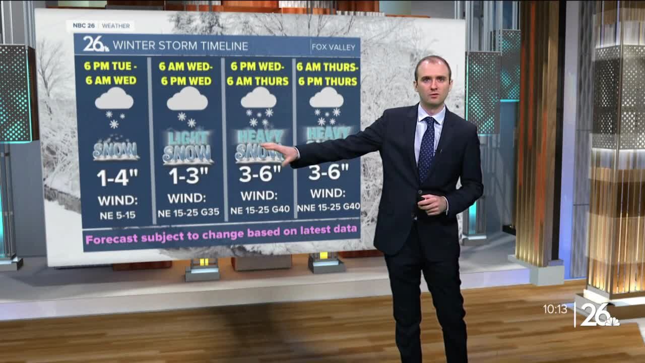
A cold front moves in tonight with some cloudy weather, but otherwise, temperatures will fall into the upper teens and lower 20s. We may initially see some sunshine Monday morning, but clouds build in quickly as a clipper approaches from the west. Temperatures will rise into the mid to upper 30s during the day. Some light snow will move in the afternoon and evening. Accumulations should remain north of Highway 29 around a dusting to an inch. A long duration snow event takes shape Tuesday night through Thursday evening across Northeast Wisconsin. The first round of snow will arrive late Tuesday night after sunset. It will snow into early Wednesday morning with snowfall totals between 3-5 inches in the highest amounts. Exactly where this band sets up still isn't set, but either the far Northwoods will see minimal snowfall or Green Lake through Sheboygan will see a low amount near or under an inch. If you live between Highway 10 and Highway 29, the chance of seeing a couple inches is currently looking strong. Snowfall will taper off during the day Wednesday as winds pick up out of the northeast with gusts approaching 35-40 mph and lasting through Thursday afternoon. Some blowing and drifting snow is expected in rural areas. A few flurries or light snow showers will continue during Wednesday as we wait for the second round of snow to arrive. Snow begins to pick up Wednesday night and continue through Thursday afternoon with moderate to locally heavy snowfall. With strong northeast winds during this time, it will make for very difficult driving conditions especially for the Thursday morning commute. Snowfall will start to weaken in intensity by Thursday night as the storm finally comes to an end. Snowfall amounts could easily exceed a foot with some data projecting over a foot and a half. Keep in mind that this excludes snowfall compaction. When we see high amount of snowfall totals, sometimes all the weight of the snow can press down on the accumulations near the ground and cause the whole amount of snow to compress. While the data could say 18 inches, it might be 13 or 14 with it being compressed or compacted. Temperatures fall into the upper teens Friday with another slight chance of snow Friday night.
-
 1:45
1:45
WGBA
1 year agoStudents excited to start at "huge and beautiful" Vel Phillips Middle School
306 -
 1:11:56
vivafrei
3 hours agoCuomo for Prosecution! Fox News Goes Woke? And Whatever Else the News Brings! Viva Frei Live!
7.53K2 -
 LIVE
LIVE
Redacted News
1 hour ago🚨 WW3 Alert! Ukraine's ARMY is collapsing and Zelensky is trying to scuttle peace plans | Redacted
24,212 watching -
 LIVE
LIVE
The White House
1 hour agoPresident Trump Signs Executive Orders, Apr. 23, 2025
1,617 watching -
 LIVE
LIVE
Candace Show Podcast
1 hour agoENOUGH! It’s Time For Jordan Peterson To Clean His Own Room | Candace Ep 181
5,099 watching -
 LIVE
LIVE
Dr Disrespect
5 hours ago🔴LIVE - DR DISRESPECT - WARZONE - HOW TO WIN SOLO GAMES
2,568 watching -
 1:59:54
Darkhorse Podcast
2 hours agoMad Scientists: The 273rd Evolutionary Lens with Bret Weinstein and Heather Heying
19.6K22 -
 2:23:37
The Quartering
4 hours agoA WAR On The Right Is Brewing, RFK With LANDMARK Win, Ivermectin FINALLY Approved & More
109K44 -
 DVR
DVR
RiftTV/Slightly Offensive
2 hours ago $2.77 earnedCHAOS in Trump Admin, Tesla Profits CRASH, Hegseth in TROUBLE? | The Rift Report
17K6 -
 LIVE
LIVE
The HotSeat
2 hours agoAmerica: The Upside Down Is REAL!
1,286 watching