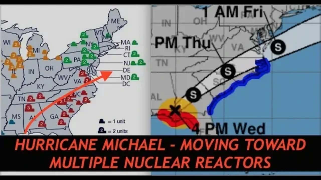
Hurricane Michael On Path of Several Nuclear Reactors, Latest Maps, Charts, Live Data, Flooding
Awesome Specials LP Listeners 92 Meals for $75 - 25 Year Shelf Life http://www.preparewithleakproject.com 1-888-411-0779
*This is a paid sponsorship by My Patriot Supply
Hurricane Michael, Latest Data, Maps, Graphs, Flooding Charts, Live Wind Speeds, Nuclear Reactor Locations.
Links to Graphs, Maps, Slides, Data discussed in podcast
https://www.nhc.noaa.gov/storm_graphics/AT14/refresh/AL142018_5day_cone_no_line_and_wind+png/152003.png
https://www.nhc.noaa.gov/refresh/graphics_at4+shtml/212416.shtml?ero#contents
https://www.nrc.gov/reactors/operating/map-power-reactors.html
Google Maps
http://www.maps.google.com
5G Shielding Tin Foil, Limited Edition Caps
http://www.leakproject.com/shop
Exclusive Content @ http://www.leakproject.com
YouTube Channel @ http://www.youtube.com/clandestinetimelord
-
 33:32
33:32
Leak Project
5 days ago $2.12 earnedLeaked Images of 3I/ATLAS & Secret Military Space Programs to Deflect It!
1.44K4 -
 LIVE
LIVE
Wendy Bell Radio
4 hours agoWELCOME TO THE SEWER
7,051 watching -
 DVR
DVR
Chad Prather
16 hours agoStanding Firm When the World Says Sit Down
61.2K41 -
 LIVE
LIVE
LFA TV
12 hours agoLIVE & BREAKING NEWS! | THURSDAY 11/20/25
2,702 watching -
 LIVE
LIVE
AP4Liberty
11 hours agoTrump–Musk Alliance 2.0: What Their Sudden Reconciliation Means for America’s Future
369 watching -
 22:20
22:20
World2Briggs
18 hours ago $13.08 earnedEveryone Is Leaving These 15 States. Truth Behind the Trend.
32.1K15 -
 4:24
4:24
Gamazda
19 hours ago $4.84 earnedDeep Purple – Smoke On the Water (Live Piano Cover in a Church)
23.2K14 -
 12:54
12:54
Brad Owen Poker
14 hours ago $1.79 earnedI Make Final Table! I’m Going To $10,400 WPT World Championship!!
22.6K1 -
 10:00
10:00
TheMightyMcClures
22 days ago $1.31 earnedWe Fed 500 Families!
24.1K4 -
 6:23
6:23
The Shannon Joy Show
14 hours agoWas Covid a MILITARY OPERATION?
21.9K10