Satellite Imagery Captures Mauna Loa Eruption
2 years ago
976
Satellite Imagery Captures Mauna Loa Eruption
The Mauna Loa volcano in Hawaii began erupting just before midnight on Sunday, November 27, according to the USGS Volcanoes.
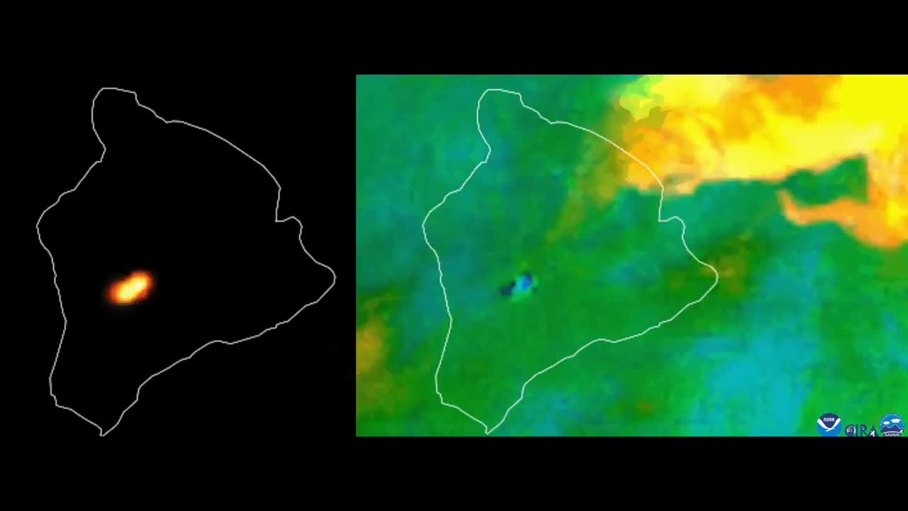
NOAA Satellites released this imagery and said it showed the heat signature and sulfur dioxide released when the volcano erupted.
The Hawaii Emergency Management Agency said that though there were reports of lava overflowing from the Mauna Loa caldera, there was no threat to populated areas on Monday and no evacuation orders were in place.
The National Weather Service issued an ash fall advisory for portions of the Big Island of Hawaii on Monday.
Loading comments...
-
 25:49
25:49
GritsGG
8 hours agoRank 1 Player Crushes Solo Lobby!
1.24K -
 35:14
35:14
The Pascal Show
9 hours agoHE'S GONNA SUE COLDPLAY?! Astronomer HR Resigns & Ex-CEO Set To Sue Coldplay Over Kiss Cam Drama
856 -
 LIVE
LIVE
Lofi Girl
2 years agoSynthwave Radio 🌌 - beats to chill/game to
330 watching -
 19:18
19:18
DeVory Darkins
5 hours ago $22.72 earnedDemocrat non-profit SCAM EXPOSED as Trump OBLITERATES Newsom
30.8K54 -
 23:58
23:58
Stephen Gardner
7 hours ago🔥Obama THROWS Adam Schiff under the bus to obstruct Trump!
22.5K102 -
 38:44
38:44
The Why Files
4 days agoProject Ancient Arrow | The NSA's Secret War Against Our Future
59K73 -
 2:36:06
Barry Cunningham
8 hours agoPRESIDENT TRUMP IS TRULY USHERING IN THE GOLDEN AGE OF AMERICA! CAN YOU FEEL IT?
109K44 -
 3:47:25
SynthTrax & DJ Cheezus Livestreams
3 days agoFriday Night Synthwave 80s 90s Electronica and more DJ MIX Livestream 2K Celebration SPECIAL EDITION 530pm PST / 830pm EST
52K5 -
 2:21:54
VapinGamers
5 hours ago $3.33 earnedDestiny 2 - Edge of Fate Legendary Run Part 3 - !rumbot !music
28.7K -
 2:04:25
TimcastIRL
8 hours agoTrump DOJ Gives Ghislaine Maxwell Limited IMMUNITY As She Rats On 100+ People | Timcast IRL
234K170