Stevens Creek, Branch C: Initial Recon
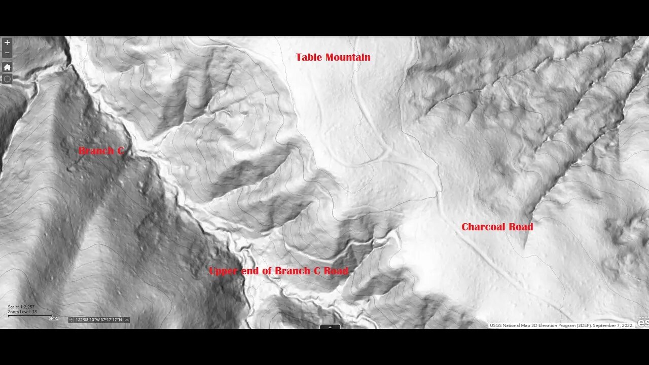
While looking at the USGS hill shade map of Branch C, I saw what looked like an old road running up the south side of this branch of Stevens Creek.
It's very faint at the bottom where Branch C joins Stevens Creek, but it gets more and more distinct the farther upstream you go until it eventually joins up with Charcoal Road.
This road up Branch C may help to explain the building at the confluence with Stevens Creek that's shown on the 1895 USGS topo map. It would be located at the point where the Canyon Road continued up towards Branch D and this fork of the road running up Branch C.
Charcoal production in this area mentioned in the Saratoga Gap OSP history page:
https://www.openspace.org/preserves/saratoga-gap#history
This is where Charcoal Road joins up with Skyline Blvd/Hwy. 35. And this road up Branch C clearly joins up with the bottom of Charcoal Road on top of Table Mtn.
If anyone has any links to information on this road or where the New Almaden smelters got their fuel, please post up in the comment section below. This is pure speculation on my part, but this is likely one of the largest consumers of fuel (charcoal assumed) in the area at this time.
New Almaden Mine info: https://en.wikipedia.org/wiki/New_Almaden
Image Description: Smelting Works — at the New Almaden Mine.
Located in Almaden Quicksilver County Park, Santa Clara County, Northern California.
Date 1863
Source http://www.getty.edu/art/gettyguide/artObjectDetails?artobj=65339
Author Carleton Watkins (1829–1916)
About the USGS HTMC:
https://www.usgs.gov/programs/national-geospatial-program/historical-topographic-maps-preserving-past
View/download maps on the TopoView site:
https://ngmdb.usgs.gov/topoview/
I used the 1895 Palo Alto quadrangle or the 1900 historical topo as listed in GaiaGPS:
https://www.gaiagps.com/
More to come...
Subscribe for more content like this
Comment, rate, share & click the bell icon
And as always, thanks for watching
-
 2:54:58
CAMELOT331
7 hours agoYouTube Just Told Me I OWE THOUSANDS $ TO THEM... update
30.9K5 -
 2:00:53
Tundra Tactical
14 hours ago $1.95 earned🛑LIVE AT 9PM CST!! Your Government Hates Your Guns : DOJ Holds Firm On National FIREARMS ACT
18.2K -
 2:44:56
DLDAfterDark
4 hours ago $3.20 earnedAre YOU The Guy That Ruins Thanksgiving?? - God Guns & Gear
24.9K -
 2:58:31
NewsTreason
6 hours agoDECLAS w/ Rambo & Dave: Nuremberg 2.0 | MTG Exits Stage Left | Mamdani Psyop Confirmed, 8pm EST
68.5K68 -
 LIVE
LIVE
meleegames
6 hours agoSONG REQUESTS CLOSED - Melee Music - Beat Hazard 3 - Devil Inside
129 watching -
 2:13:31
The Connect: With Johnny Mitchell
13 hours ago $3.28 earnedIs Garth Brooks A Serial Killer? Exposing The Dark Secrets Of Country Music's Biggest Star
15K4 -
 1:00:49
MattMorseTV
7 hours ago $89.26 earned🔴Massive VICTORY in the SUPREME COURT.🔴
103K138 -
 4:08:14
GritsGG
5 hours ago#1 Most Warzone Wins 4015+!
14.9K -
 4:20:08
Biscotti-B23
9 hours ago $1.07 earned🔴 LIVE STREAM ENDS WHEN I GET 100 WINS 🥵 INVINCIBLE VS CLOSED ALPHA
12.5K3 -
 12:38
12:38
Timcast
1 day agoJasmine Crocket HUMILIATED By CNN To HER FACE Over Epstein LIE | Tim Pool
112K77