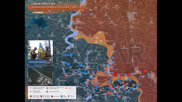
Rybar Map on Liman (1.10.22 14:00)
The situation in the Liman direction
as of 14.00 October 1, 2022 - @Rybar
The Armed Forces of Ukraine concentrated their main efforts on three sections of the roads: Liman - Zarechnoye, Torskoye - Kremennaya, Torskoye - Svatovo. Properly distributing forces, the Ukrainian formations focused on cutting the lines of communication of the Russian troops.
At the same time, the pushing through of Russian defensive orders continued in Liman itself, Stavki, the northern environs of Yampol and along the “road of life”.
▪️By noon on October 1, the Armed Forces of Ukraine managed to physically cut off the Torskoye-Svatovo road and pin down the forces of the RF Armed Forces in the Ternov area.
▪️The Ukrainian flag was raised at the western entrance (49.012093, 37.772098) to Liman: at least 20% of the city was controlled by the enemy by that time. This is evidenced by the absence of sounds of small arms combat and artillery strikes at the western entrance to the city.
The fighting shifted to the center and eastern part of Liman, the southern outskirts of Stavki, and the northern outskirts of Yampol. Communication between Torsky and the Liman garrison is blocked by fire.
▪️The RF Armed Forces strike at Zarechny (Kirovsk), which includes Ukrainian formations. It is through Zarechnoye that the Liman-Torskoye road passes.
▪️The Torskoye-Kremennaya road is under constant fire control of the Armed Forces of Ukraine, Ukrainian maneuver groups are trying to tie up Russian units in battle.
🔻Despite the measures taken by the Russian command, it turned out at best to slow down the advance of the Ukrainian troops. At this stage, it is not possible to turn the tide of the battles for Liman.
-
 0:14
0:14
Itapirkanmaa2
2 years agoYuri Podolyaka on Liman (1.10.22)
2281 -
 0:17
0:17
Itapirkanmaa2
2 years agoWithdrawal from Liman (1.10.22)
3479 -
 1:43
1:43
MR Realpolitik
2 years agoRYBAR Ukraine War Map Sept 16, 22 Battle for Kherson
103 -
 59:57
59:57
The StoneZONE with Roger Stone
4 hours agoJ6 Martyr Enrique Tarrio Describes Inhumane Prison Conditions Ordered by Biden | The StoneZONE
21.5K1 -
 16:48
16:48
Tundra Tactical
4 hours ago $0.13 earnedAffordable Medical Gear From ACETAC SHOT Show 2025
17.1K1 -
 1:46:16
Redacted News
7 hours agoRFK CONFIRMATION: Kennedy goes to WAR with Big Pharma Democrats in Fiery Hearing | Redacted Live
183K384 -
 57:31
57:31
Candace Show Podcast
7 hours agoBREAKING! Taylor Swift Turns Against Blake Lively & Ryan Reynolds | Candace Ep 141
181K191 -
 1:04:59
Sarah Westall
4 hours agoRFK Jr Report, Constitution Suspended, War Time Procedures in Place, WHO Exit, DOD w/ Sasha Latypova
34.5K27 -
 1:56:37
Melonie Mac
8 hours agoGo Boom Live Ep 35!
43.2K12 -
 1:01:13
LFA TV
12 hours agoPRESIDENT TRUMP SIGNS LAKEN RILEY ACT | BASED AMERICA 1.29.25 6pm
55.1K7