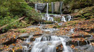
Virginia Hawkins Falls, South Carolina -- DJI Drone Footage
This was a 2.5 mile hike off of Horse Pasture Rd in Jocassee Gorges. The link below will get you to a good parking area very near the trailhead. There is a white sign marking the trailhead with gos along a now closed off gravel road for about a mile, then you will see the Virginia Hawkins Campground on your right. Follow the signs for the falls from there! Best seen after a good rain as I image it drys up during longer droughts.
Instagram: https://www.instagram.com/nevergrowbored
My Hiking Blog: https://nevergrowbored.blogspot.com
Twitter: https://twitter.com/seanhogan410
Google Maps: https://goo.gl/maps/Gbg9GEwZHtvjiM2L9
Music Link: https://soundcloud.com/whoisryke/sets/ryke-nightwalker
Trail App I use: https://www.alltrails.com
Drone I Use: https://store.dji.com/product/spark
Handheld Gimbal I Use: https://www.dji.com/osmo-pocket
-
 5:33
5:33
HDCarolina
2 years agoVirginia Hawkins Falls
1.47K -
 4:48
4:48
Cov723
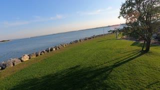
2 years agoDrone Flight in South Carolina
52 -
 1:14
1:14
KSHB
2 years agoDrone footage
13 -
 1:22
1:22
Ramble On
1 year agoBetter Drone Footage
8 -
 0:25
0:25
TheSouthernWoodsmanUk
2 years agoDrone footage. Waterside.
72 -
 10:22
10:22
Edwardkosinski
2 years ago $0.01 earnedCherry Grove South Carolina
34 -
 0:54
0:54
KJRH
2 years agoOkmulgee Drone Footage
3 -
 0:40
0:40
KJRH
2 years agoOkmulgee Drone Footage 2
3 -
 0:47
0:47
Reuters
2 years agoDrone footage shows ongoing wildfire in South Korea
2551 -
 16:20
16:20
Guns & Gadgets 2nd Amendment News
15 hours agoClarence Thomas DESTROYS Opinion Of Today's Anti-2A Ruling!.mp4
22.6K13