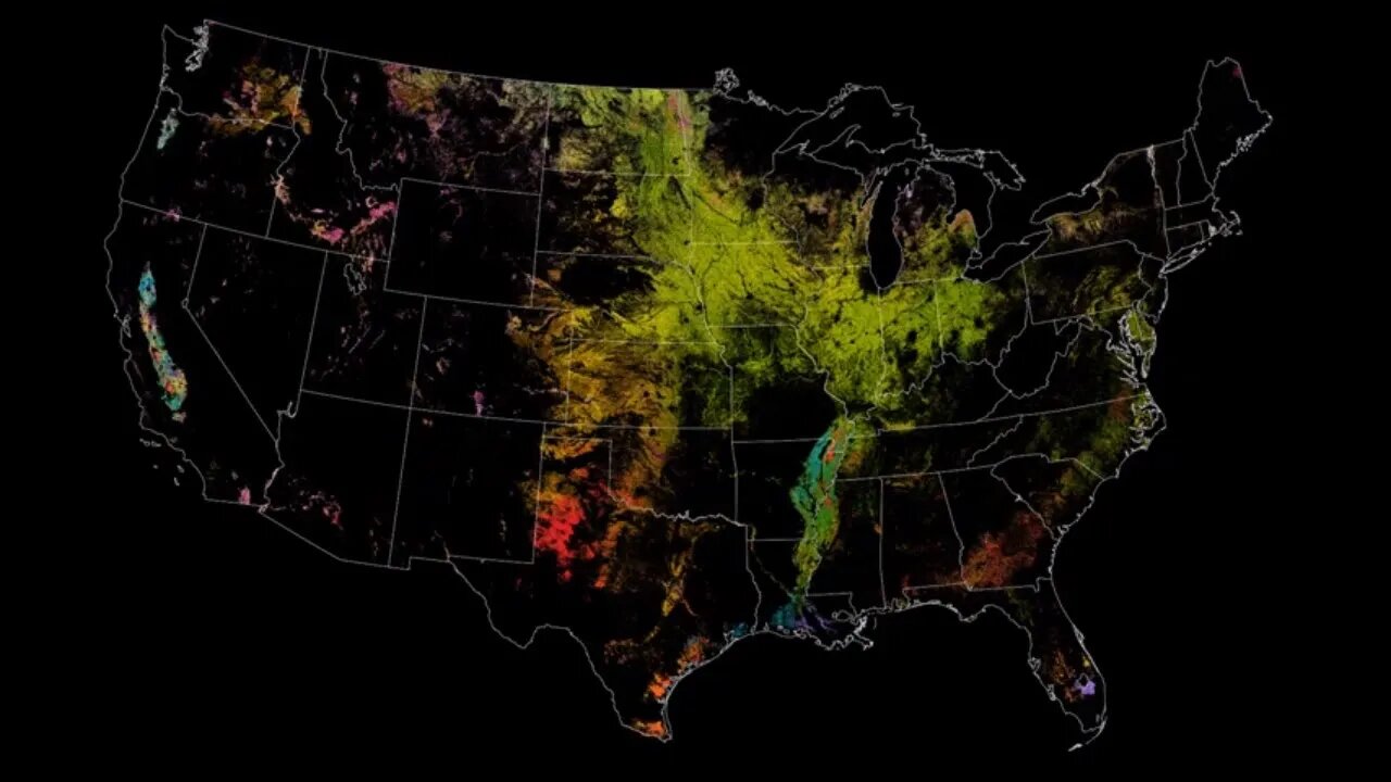
🔴👀🔴 NASA Satellites Keep Watch on U.S. Food Supply
Since 2008, the USDA's National Agricultural Statistics Service, or NASS, has drawn on Landsat data to monitor dozens of crops in the lower 48 states as part of NASS's Cropland Data Layer program. The Cropland Data layer uses Landsat and similar sensors to identify what crop is growing where in the country. Separately, NASS uses NASA's Moderate Resolution Imaging Spectroradiometer (MODIS) instruments aboard the Aqua and Terra satellites to monitor daily vegetation health and growth stage, all indicators of crop yield.
Music: "Downloading Landscapes" by Andrew Michael Britton [PRS] and David Stephen Goldsmith [PRS]. Published by Atmosphere Music Ltd [PRS].
Video Credit: NASA's Goddard Space Flight Center. Data from the USDA National Agricultural Statistics Service Cropland Data Layer.
Matthew R. Radcliff (USRA): Lead Producer
Kel Elkins (USRA): Animator
Horace Mitchell (NASA/GSFC): Animator
Jessica Merzdorf (Telophase): Writer
Rani Gran (NASA/GSFC): Writer
Jefferson Beck (USRA): Narrator
This video is public domain and can be downloaded from NASA Goddard's Scientific Visualization Studio at: https://svs.gsfc.nasa.gov/13417
If you liked this video, subscribe to the NASA Goddard YouTube channel: https://www.youtube.com/NASAGoddard
Follow NASA’s Goddard Space Flight Center
· Instagram http://www.instagram.com/nasagoddard
· Twitter http://twitter.com/NASAGoddard
· Twitter http://twitter.com/NASAGoddardPix
· Facebook: http://www.facebook.com/NASAGoddard
· Flickr http://www.flickr.com/photos/gsfc
Subscribe and hit the bell, Over video 150 sources!
My new Patreon page https://www.patreon.com/user?u=26453564
This channel might be gone in weeks, YouTube will not monetize it and they plan to remove non-commercially viable channels, not viable YouTube? how come this channel has over a million views?
Subscribe to my Bitchute channel before this one is gone!
https://www.bitchute.com/channel/kurtelliott/
-
 8:44
8:44
Kurt's News
6 months agoKimmel CRIES About Trump, Tapper Gets SCHOOLED on Pete Hegseth & Black Millionaire Claims Racism
145 -
 36:44
36:44
NordicVentures
5 days ago $0.24 earnedWINTER Bushcraft 2 Nights: Building ALONE a Survival Shelter
1.61K -
 LIVE
LIVE
Amish Zaku
7 hours agoRumble Spartans July Event- Classic Halo Multiplayer
77 watching -
 LIVE
LIVE
Phyxicx
2 hours agoRumble Halo Night w/ Rumble Spartans! - 7/26/2025
41 watching -
 7:12
7:12
nospeedlimitgermany
2 days ago $0.14 earnedAudi TT 1.8 T Roadster | 180 PS | Top Speed Drive German Autobahn No Speed Limit POV
1.98K1 -
 LIVE
LIVE
Dragoon_B
1 hour agoDragoon - Counter Strike - Premier Grind
40 watching -
 LIVE
LIVE
CODZombieGod115
3 hours ago🔴LIVE - Janus Towers DLC 4 Hype | Black Ops 6 Zombies
56 watching -
 53:25
53:25
SouthernbelleReacts
4 days ago $0.11 earnedMy Reaction to 12 Monkeys (1995) | Time Travel, Madness & Bruce Willis Brilliance
2.34K1 -
 9:04
9:04
Blackstone Griddles
1 day agoDouble Western Smashburgers on the Blackstone Griddle
2.85K1 -
 3:30:54
Barry Cunningham
7 hours agoTULSI GABBARD AND DAN BONGINO SOUND ALARMS! CNN MISREADS EPSTEIN EFFECT! AND MORE!
126K107