NASA satellite images show Lake Mead water levels plummeting to lowest point since 1937
Satellite images released by NASA this week show a dramatic drop in water levels over the last 22 years at Lake Mead.
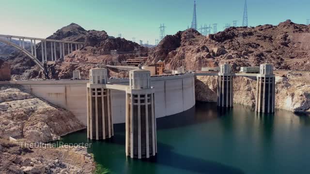
NASA confirmed that water levels in Lake Mead, located in Nevada and Arizona, are at their lowest since April 1937, when the reservoir was being filled for the first time.
As of Monday, Lake Mead, the largest reservoir in the United States, was filled to 27% capacity, according to NASA.
The photos shared by the NASA Earth Observatory, taken in 2000, 2021 and 2022, show Lake Mead appearing to grow less and less full of water, even in the one-year span between 2021 and 2022. The image from 2000 shows swaths of Lake Mead full of water, while the image from 2022 only shows one section, known as Overton Arm
Watch the video for more info... Don't forget to click the Subscribe button, it helps a lot and doesn't cost a thing. Either way, thanks for taking the time out of your day to view one of our videos. #Trending #News #Viral Donate to: Cashapp - $EachOneHelpOne1 or PayPal to Docholidae321@gmail.com
I Support Ukraine: All Purpose Notebook: https://www.amazon.com/dp/B09X2WTTGZ/ref=sr_1_13?keywords=I+Support+Ukraine+notebook&qid=1649387214&sr=8-13
Stand With Ukraine: All Purpose Notebook: https://www.amazon.com/dp/B09X365X38/ref=sr_1_2?crid=JQJN90AYSXDY&keywords=Stand+With+Ukraine+notebook+milton&qid=1649385316&sprefix=stand+with+ukraine+notebook+milton%2Caps%2C1187&sr=8-2
Unique Notebooks, Diaries, Password Logs, Wedding Planners, and much more: https://www.amazon.com/Milton-V-Thomas-III/e/B09GZXBH7V?ref=sr_ntt_srch_lnk_1&qid=1648002363&sr=8-1
Read the article here: https://www.aol.com/news/nasa-satellite-images-show-lake-132926331.html
-
 40:14
40:14
Uncommon Sense In Current Times
16 hours ago $1.23 earnedThe Dating Crisis in America | J.P. De Gance on the Church’s Role in Restoring Family & Faith
25.4K3 -
 12:35
12:35
Red Pill MMA
18 hours agoNow We Know The Truth.. Hero Who Stopped Raja Jackson Speaks Out
2.84K4 -
 41:04
41:04
Coin Stories with Natalie Brunell
1 day agoCooking, Culture & Crypto: Norma Chu’s Food Empire Turns Bitcoin Treasury
5.75K -
 8:03
8:03
MattMorseTV
16 hours ago $7.28 earnedThings in the UK just got INSANE...
84.2K125 -
 3:02:10
daniellesmithab
11 hours agoAlberta Next: Fort McMurray Town Hall
15K1 -
 2:11:17
Side Scrollers Podcast
20 hours agoINSANE Illegal Migrant Propaganda Xbox Game + Paypal REFUSES To Pay Dev + More | Side Scrollers
62.7K3 -
 20:58
20:58
GritsGG
1 day agoProtect the President Challenge on Warzone!
18.7K -
 1:49:07
The Michelle Moore Show
2 days ago'Biden's Immigration Mess, President's Trump Spiritual Cry For Help, English Speaking Truckers Only, Woke CEO's Killing of Conservative Brands, Palantir's Kill Chain' Mark Taylor: The Michelle Moore Show (Aug 25, 2025)
39.4K97 -
 LIVE
LIVE
Lofi Girl
2 years agoSynthwave Radio 🌌 - beats to chill/game to
236 watching -
 2:14:18
The Pascal Show
15 hours ago $1.11 earnedTHEY LIED TO POLICE AGAIN? Jake & Rebecca Haro Have Lost Their Minds! Emmanuel Haro Search Continues
13.9K