Premium Only Content

Grizzly Flat North Trail / Middle Road: 2nd Visit
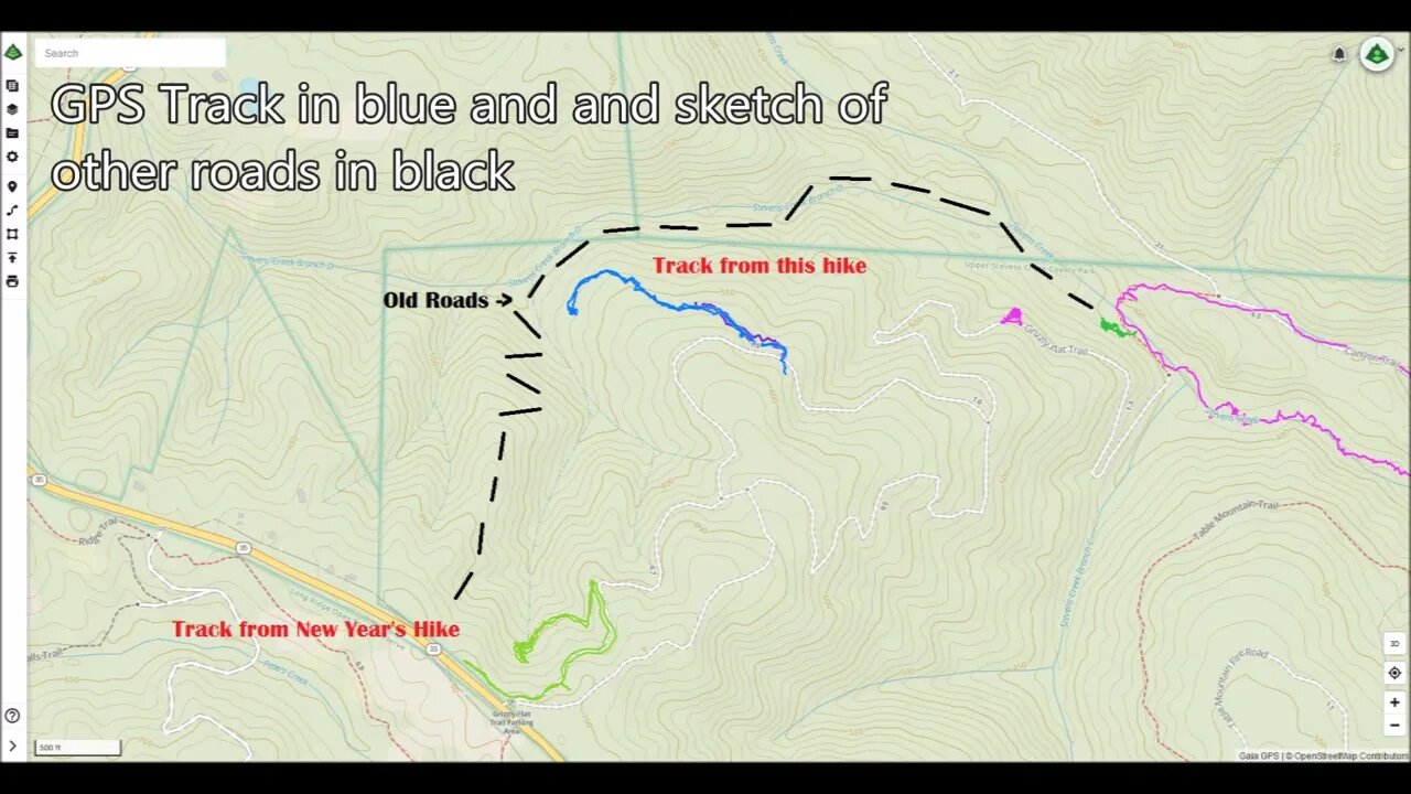
Short stop on a bike ride to check out an old road I saw near the middle of the Grizzly Flat / North Trail in Upper Stevens Creek County Park. Wanted to see where it went and if it may have connected down to the end of the 1897 road at the end of Stevens Creek Branch D.
This road doesn't appear on any maps. It looks like it may been constructed around the same time as the Grizzly Flat road. Grizzly Flat North Road first appears on the 1961 USGS topo map.
There appear to be at least 3 roads that come together at the bottom of the Branch D canyon. 2 of them seem to be quite old based on their minimal construction. Then this road seems more modern in terms of wider radius turns and that it joins up to an existing road. But then the question is, what was this built road for? Were the 2 older roads in the canyon still in use when this road was built? If not, then why did this road go down to the same area that the 2 old roads seem to meet up in? Maybe this road was abandoned when the county acquired this land for the county park in 1965.
About the USGS HTMC:
https://www.usgs.gov/programs/national-geospatial-program/historical-topographic-maps-preserving-past
View/download maps on the TopoView site:
https://ngmdb.usgs.gov/topoview/
I used the 1897 Palo Alto quadrangle or the 1900 historical topo as listed in GaiaG:
https://www.gaiagps.com/
More to come...
Subscribe for more content like this
Comment, rate, share & click the bell icon
And as always, thanks for watching
#USGS #HillShade
-
![If You Smell LALALALA What CHiLi IS COOKING!!... #RUMBLETAKEOVER [Overwatch 2]](https://1a-1791.com/video/s8/1/e/s/X/3/esX3u.0kob-small-If-You-Smell-LALALALA-What-.jpg) 4:27:40
4:27:40
CHiLi XDD
10 hours agoIf You Smell LALALALA What CHiLi IS COOKING!!... #RUMBLETAKEOVER [Overwatch 2]
25.6K1 -
 LIVE
LIVE
Delnorin Games
11 hours ago🔴 Live - Star Citizen
1,860 watching -
 1:39:44
HELMET FIRE
12 hours agoDEADROP IS BACK!
137K8 -
 10:03
10:03
Tundra Tactical
14 hours ago $14.84 earnedBrandon Herrera Vies Bid for ATF Director!
87.7K15 -
 22:01
22:01
DeVory Darkins
1 day ago $35.30 earnedHakeem Jeffries SHUTS DOWN The View as Matt Gaetz Speaks out
77.1K127 -
 2:02:54
Mally_Mouse
13 hours agoLet's Play!! - Spicy Saturday
57.2K2 -
 1:33:06
Slightly Offensive
14 hours ago $29.98 earnedAre You Ready for What's Coming Next? | Just Chatting Chill Stream
74.5K41 -
 32:10
32:10
MYLUNCHBREAK CHANNEL PAGE
1 day agoThe Gate of All Nations
146K63 -
 13:07
13:07
Sideserf Cake Studio
18 hours ago $3.82 earnedIS THIS THE MOST REALISTIC SUSHI CAKE EVER MADE?
63K4 -
 21:08
21:08
Clownfish TV
1 day agoElon Musk Tells WotC to BURN IN HELL for Erasing Gary Gygax from DnD!
50.6K16