Return to Laurel Park in Stevens Creek Canyon
A return trip to this area to check out the dry creek channel to see if there was anything of interest to see in this area that couldn't be seen from the road.
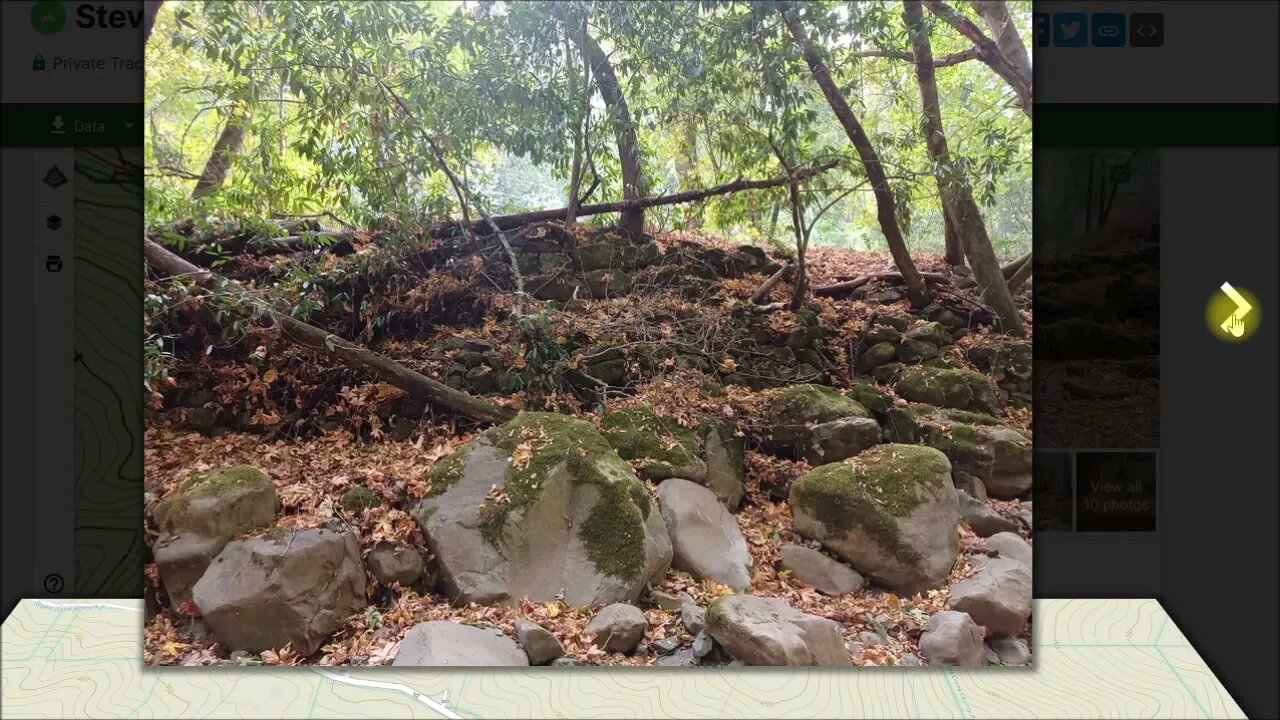
There was a massive stone wall built along the creek bank near where the stone foundations were located. Also observed pieces of concrete rubble in the dry creek bed and even saw some of that as part of creek bank rip-rap. I suspect in days gone by, that sort of material was used for road and bank repairs. In the earlier video, I had seen some concrete slabs near the Laurel Park location that I thought might have been related. But now I don't think that's the case.
The USGS topo map in Gaia GPS shows 2 structures in the area of the stone foundations. Although that map shows them on the north side of the creek, I suspect they are really on the south side, between it and the road. I'm not sure what date that USGS topo was surveyed, but it also shows a few more structures that are no longer visible. The 1961 USGS topo map shows some details in this area, but the version available in GaiaGPS is missing this area.
Didn't see anything interesting in the area between the 2 bridges. Below the lower bridge, I did see that I was near a pond according to the GPS map. On the way up to that, I stumbled across an old road, both of will be investigated in upcoming videos.
County bridge information, 37C0604 and 37C0605:
https://bridgereports.com/ca/santa-clara/
More to come...
Subscribe for more content like this
Comment, rate, share & click the bell icon
And as always, thanks for watching
-
 LIVE
LIVE
Nerdrotic
2 hours agoBBC Crashout | Hollywood For Sale | Battle of the Blonde's | Witcher BOMBS - Friday Night Tights 380
1,241 watching -
 14:26
14:26
Upper Echelon Gamers
3 hours ago $0.13 earnedThe Carvana Scam - A Predatory BUBBLE
1133 -
 LIVE
LIVE
LFA TV
20 hours agoLIVE & BREAKING NEWS! | FRIDAY 11/14/25
1,098 watching -
 LIVE
LIVE
Dr Disrespect
6 hours ago🔴LIVE - DR DISRESPECT - BLACK OPS 7 - LAUNCH DAY CHAMPION
1,135 watching -
 LIVE
LIVE
StoneMountain64
4 hours agoCall of Duty Black Ops 7 Gameplay LAUNCH DAY
182 watching -
 18:15
18:15
Clintonjaws
5 hours ago $3.25 earnedCNN Audience Shocked By Dem's Slanderous Comments At Trump
24.2K20 -
![MAHA News [11.14] - Govt War on Small Ranchers, GLP-1 Craze, Hemp Ban, Mercury out of Vaccines](https://1a-1791.com/video/fww1/f2/s8/1/i/X/E/z/iXEzz.0kob-small-MAHA-News-11.14.jpg) LIVE
LIVE
Badlands Media
12 hours agoMAHA News [11.14] - Govt War on Small Ranchers, GLP-1 Craze, Hemp Ban, Mercury out of Vaccines
470 watching -
 1:23:17
The Quartering
5 hours agoTucker Reveals FBI Coverup For Trump Assassin, Walmart CEO Quits & Tim Pool Unleashes
55K62 -
 34:23
34:23
Tucker Carlson
9 hours agoWho Is Thomas Crooks?
338K496 -
 2:05:33
The Culture War with Tim Pool
19 hours agoDating In The Modern Age DEBATE, Myron Gaines vs Brian Shaprio | The Culture War LIVE Debate
100K154