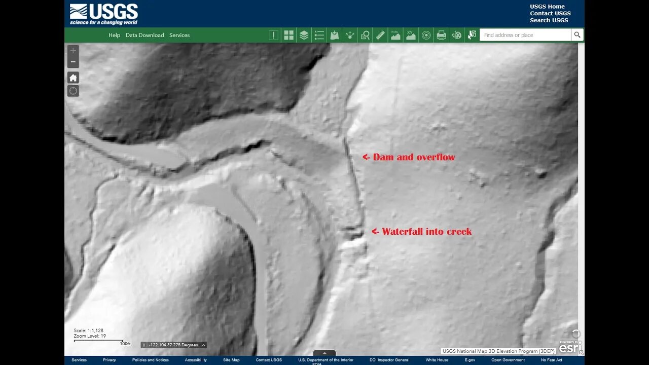
Dam and Overflow Channel: "Laurel Park" Pond
A return trip to this area to check out the old road, pond dam and overflow channel for the pond shown on the 1961 and later topo maps. None of the maps name this side stream or pond nor show either of the 2 old roads into this area.
Also, wanted to see if the old road could be used to access the bench to the east of the creek where 2 structures are shown on the 1948 topo map. With the erosion of the old road by the overflow channel, it wasn't possible to follow the old road any farther. Will return later in the year, likely after the water level in the creek has gone down. It's a lot easier to hike up the dry creek bed and look for routes up the side without having to keep hopping from side to side.
My take is that the structures on the bench were abandoned prior to the pond dam being built sometime in the 1950's. The overflow for the pond was excavated along the old road, as it made for easy access for the machines. I think the overflow channel wasn't maintained and it gradually filled in at the bottom end and let water pour over the sides further up.
Also, the thumbnail is a shot of the USGS National Map Viewer with the "hill shade" 3D shading overlay. We'll take a deeper dive into this in a future video:
https://apps.nationalmap.gov/viewer/
This tool is seriously cool, it's just like slapping a pair of those X-ray specs they used to advertise in the comic books back in the day.:
https://en.wikipedia.org/wiki/X-ray_specs
If anyone has any information on this area like who built the pond, what was it's purpose, etc. feel free to post up in the comments:
https://www.google.com/maps/@37.2750562,-122.1051916,18z/data=!5m1!1e4
County bridge information, 37C0604 and 37C0605:
https://bridgereports.com/ca/santa-clara/
Restoration:
https://sccgov.iqm2.com/Citizens/Detail_LegiFile.aspx?Frame=&MeetingID=8498&MediaPosition=&ID=85534&CssClass=
More to come, looking for the lower road and the outflow channel for the pond.
Subscribe for more content like this
Comment, rate, share & click the bell icon
And as always, thanks for watching
-
 LIVE
LIVE
Sarah Westall
1 hour agoYounger Human Brains are Vastly Different than Older Generations w/ Neurologist Dr Jack McCallum
230 watching -
 LIVE
LIVE
megimu32
40 minutes agoON THE SUBJECT: The Movies That Made Millennials — And the Ones That Missed 🎥
95 watching -
 18:13
18:13
T-SPLY
3 hours agoChicago Mayor Accuses ICE Of Human Rights Violations!
14110 -
 1:09:47
iCkEdMeL
1 hour ago $2.16 earned🔴 Redwood City Standoff Erupts in Gunfire | Police Shooting Update
5.96K2 -
 13:10:31
LFA TV
23 hours agoLIVE & BREAKING NEWS! | TUESDAY 11/11/25
180K34 -
 30:53
30:53
BonginoReport
8 hours agoMonica Kelsey: The Woman Who Is Saving Countless Babies - Nightly Scroll w/ Hayley Caronia (Ep.175)
90.8K17 -
 1:08:36
Kim Iversen
5 hours agoFrom Head Chopping to The Oval Office: Who is Al-Sharaa?
96.6K76 -
 DVR
DVR
The Bold Lib
3 hours agoBOLDCHAT: The Intolerant Left | Veteran's Day w/ANGELA BELCAMINO
12.2K1 -
 DVR
DVR
Quite Frankly
6 hours agoVeterans Day Lies, Legalized Betting, And More | Sal & J Gulinello 11/11/25
17.5K5 -
 LIVE
LIVE
Tundra Tactical
8 hours ago $2.42 earned🛑LIVE NOW!! Dad Gamer Attempts To Dunk On Nerds
106 watching