1838 San Andreas Fault Earthquake, 184th Anniversary
A nice find from the OsmAnd Wikipedia layer, not only does this area contain tectonic blocks, speleothems, but it's also the epicenter of a little known earthquake!
Real easy to get to this location, just take the Grizzly Flat Trail where it branches off the Canyon Trail in Upper Stevens Creek County Park. Drop down the trail until you hit the sharp left turn down to the switchbacks.
Besides being a nice section of technical single track, this section of trail has a lot of interesting geology going on. You won't find any of that information on the official maps or trail guides. Instead, you need to spend the time observing what's there, then research what you think you're seeing, explore some more, and repeat. I find this to be much more satisfying than to have trail with marked signs and a guide book that you blindly follow.
OsmAnd WIkipedia layer:
https://wiki.openstreetmap.org/wiki/OsmAnd#Strong_Wikipedia_Integration
1838 San Andreas earthquake:
https://en.wikipedia.org/wiki/1838_San_Andreas_earthquake
https://youtu.be/mDLw9tCSRSQ
Paleo-Seismic Evidence of the 1890 and 1838 Earthquakes on the Santa Cruz Mountains Section of the San Andreas Fault, near Corralitos, California:
https://pubs.geoscienceworld.org/ssa/bssa/article-abstract/104/1/285/331810/Paleoseismic-Evidence-of-the-1890-and-1838?redirectedFrom=fulltext
San Francisco's 1906 quake was third of a series on San Andreas Fault:
https://pages.uoregon.edu/digital/uonews-archive//archive/news-release/2014/2/san-franciscos-1906-quake-was-third-series-san-andreas-fault.html
Geologic Analysis Of The Monte Bello Ridge Mountain Study Area paper:
https://fbdroch.com/book/environmental-geologic-analysis-of-the-monte-bello-ridge-mountain-study-area-santa-clara-county-california
From that paper:
"TECTONIC BLOCKS - Large angular to rounded, commonly elliptically shaped masses of relatively hard rocks surrounded by a clay-rich, sheared matrix. Occurs within shear zones and fault gouge. In the shear zones of the Franciscan rocks, these blocks range from "fist size" to masses more than one mile long."
USGS National Map Viewer w/ Hill Shade:
https://apps.nationalmap.gov/viewer/
About the USGS HTMC:
https://www.usgs.gov/programs/national-geospatial-program/historical-topographic-maps-preserving-past
View/download maps on the TopoView site:
https://ngmdb.usgs.gov/topoview/
Section of single track Canyon Trail built in 1990:
https://www.trailcenter.org/newsletter/2000/winter2000/winter2000-19f.htm
Future plan: I want to try to hike along the top of the ridge between the Canyon Trail and Stevens Creek between the Table Mtn. and Grizzly Flat trails. I'm hoping there might be some exposed sedimentary rock outcrops up there that might show if this block has been tilted in the past.
More to come...
Subscribe for more content like this
Comment, rate, share & click the bell icon
And as always, thanks for watching
#USGS #HillShade
-
 24:28
24:28
MYSTERIOUSREALITIESNOW
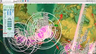
1 year agoDire Earthquake Risk & Infrastructure Vulnerability: The Grim Reality of the San Andreas Fault Line
206 -
 31:33
31:33
Christopher's Anti-Dumbass on this Timeline
6 months agoDec 1 2023 12/01/2023 -- Southern California M4.8 Earthquake East of San Diego dutchsinse
615 -
 1:43
1:43
PhoenixStar777
1 year agoCALIFORNIA EARTHQUAKE ALERT!! SF Bay Area, Los Angeles
109 -
 0:52
0:52
EarthChangingExtremities
8 months agoMagnitude 4.2 Earthquake Depth 11 km Strikes Northern California on 18th Oct 2023
17 -
 4:11
4:11
PhoenixStar777
1 year agoSanta Rosa California Earthquakes Today - Breaking News
148 -
 0:36
0:36
EarthChangingExtremities
4 months agoMagnitude 4.2 Earthquake Depth 13 km Strikes Greater Los Angeles Area, California on 25th Jan 2024
12 -
 3:42
3:42
Worldnewsreporttoday
1 year ago $0.07 earnedThe Biggest Secret In America! The Walker Lane Fault Zone!
3872 -
 2:11
2:11
CITIZEN FREE PRESS
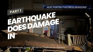
1 year agoEarthquake does damage in NCalifornia…
37 -
 1:49
1:49
History_with_MrBee
1 year agoThe Great San Francisco Earthquake
-
 0:30
0:30
The Ascension Diet Eating To Ascend - a resource for truthseekers
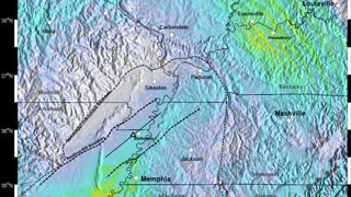
2 months agoComputer Simulation of a Magnitude 7.7 Earthquake in the New Madrid Seismic Zone
1.22K