Old 1895 Stevens Canyon Road - Along the Grizzly Flat Trail
2 years ago
2
The 1895 topo map shows the old Stevens Canyon Road running up along the location of the modern Grizzly Flat Trail.
This was filmed in early March, 2020 when I was first starting to try and figure out where this old road went. I hadn't ventured too far off the trail at this time.
About the USGS HTMC:
https://www.usgs.gov/programs/national-geospatial-program/historical-topographic-maps-preserving-past
View/download maps on the TopoView site:
https://ngmdb.usgs.gov/topoview/
I used the 1895 Palo Alto quadrangle or the 1900 historical topo as listed in GaiaGPS:
https://www.gaiagps.com/
More to come...
Subscribe for more content like this
Comment, rate, share & click the bell icon
And as always, thanks for watching
Loading comments...
-
 30:05
30:05
BALLISLIFE #1 source for original basketball content
15 hours agoHe Talked CRAZY To a D1 Hooper & Got SHIFTED To Another Planet | Hoop Dreams Ep 1
10.4K4 -
 30:13
30:13
ScammerRevolts
15 hours agoWhen I show the Scammers Their Own Pictures
9.22K3 -
 31:43
31:43
TheMonicaCrowleyPodcast
18 hours agoThe Monica Crowley Podcast: The System: Powerful, Desperate and Evil
13K11 -
 1:00:12
The StoneZONE with Roger Stone
13 hours agoDeep State Fails To Kill Trump: Naval Intel Officers Reveal Who Pulled The Strings | The StoneZONE
31.1K60 -
 8:25
8:25
Vigilant News Network
15 hours agoMissing Joe Biden Sparks Coup Speculation | Beyond the Headlines
55K122 -
 14:42
14:42
Chrissy Clark
13 hours agoDisney Drops Triggering Teddy Bear & Hunter Biden Drops Lawsuit I Underreported Stories
17.6K17 -
 52:53
52:53
Film Threat
14 hours agoDEADPOOL & WOLVERINE SOCIAL MEDIA REACTIONS | Film Threat Livecast
29.5K8 -
 4:25:06
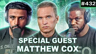
Fresh and Fit
15 hours agoMatthew Cox On Becoming FBI's Most Wanted Con Man, $55 Million In Fraud, Prison & MORE
130K60 -
 1:03:39
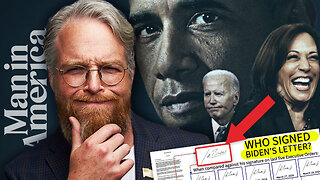
Man in America
21 hours ago🔴 LIVE: DNC COUP? Who Signed Biden’s Letter? WHERE IS JOE???
110K161 -
 2:05:27
Kim Iversen
15 hours agoUNREAL: Polls Claim Tight Race Between Harris And Trump | RESIGN! Secret Service Chief Stonewalls Congress
131K341