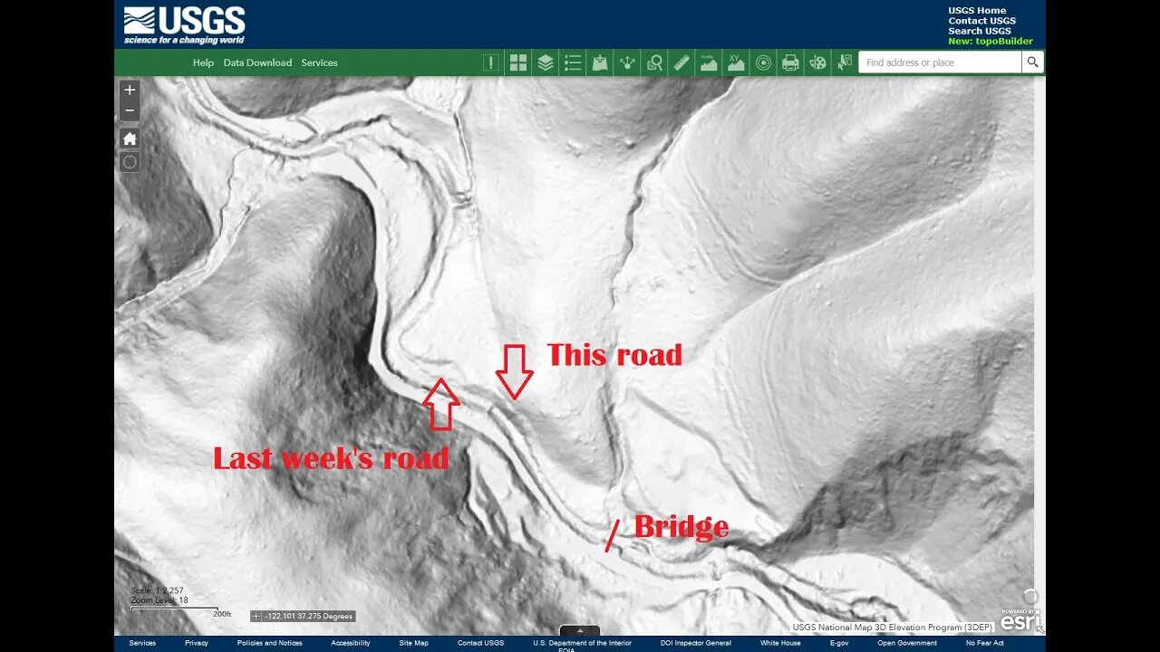
Checking out a 3rd road to the 1948 Structures
A return trip to see if this 3rd old road seen on the USGS Hill Shade map is visible and could be used to access the bench to the east of the creek where 2 structures are shown on the 1948 topo map.
It does look like this road is still there on the far side of the creek. Looks like it was accessed by the private bridge across Stevens Creek just downstream from this location. There's a small side stream that needed to be crossed before climbing up the side of the ridge to the bench. This area is still privately owned and no trespassing signs are posted around the bridge.
This is about as far down the canyon as can be easily explored as most of the land down from here is privately owned. There are another place or two down from here that may be accessible that I need to check out some day.
Thumbnail image is an annotated screen grab of the USGS hill shade map.
USGS National Map Viewer:
https://apps.nationalmap.gov/viewer/
View/download maps on the TopoView site:
https://ngmdb.usgs.gov/topoview/
Subscribe for more content like this
Comment, rate, share & click the bell icon
And as always, thanks for watching
#USGS #HillShade
-
 1:02:24
Timcast
2 hours agoBerkeley Goes BALLISTIC Over TPUSA Event, Massive BRAWL ERUPTS
126K57 -
 LIVE
LIVE
StoneMountain64
38 minutes agoBattlefield REDSEC $100k TOURNAMENT
73 watching -
 2:12:10
Steven Crowder
4 hours ago🔴Is This Really MAGA: What the Hell Is Donald Trump Doing?
347K338 -
 1:03:36
The Rubin Report
2 hours agoCNN Panel Looks Angry as Republican Points Out How Dems Shutdown Backfired
13.7K30 -
 LIVE
LIVE
Sean Unpaved
1 hour agoBen Johnson Has Caleb Williams Playing Best Football Of His Career! | UNPAVED
90 watching -
 3:11:24
Right Side Broadcasting Network
5 hours agoLIVE REPLAY: President Trump’s Veterans Day Wreath Laying Ceremony and Address - 11/11/25
58.9K18 -
 18:09
18:09
Professor Nez
2 hours ago🚨🔥HOLY MACKEREL! Chuck Schumer FLEES the Senate Floor when CONFRONTED on Obamacare FRAUD!
23.5K18 -
 1:07:04
The White House
3 hours agoPresident Trump and Vice President JD Vance Deliver Remarks
24.9K20 -
 LIVE
LIVE
The Shannon Joy Show
2 hours agoTrump & The Terrorist * MAHA Dead In DC? * Winter Weather Warfare: Live Exclusive W/ Dane Wigington
312 watching -
 35:12
35:12
Grant Stinchfield
2 hours agoHow Faith, Forgiveness, and Grit Keep the Oldest Among Us Alive and Thriving
12.3K1