Grizzly Flat North Trail / What's at the Bottom of the Middle Road?
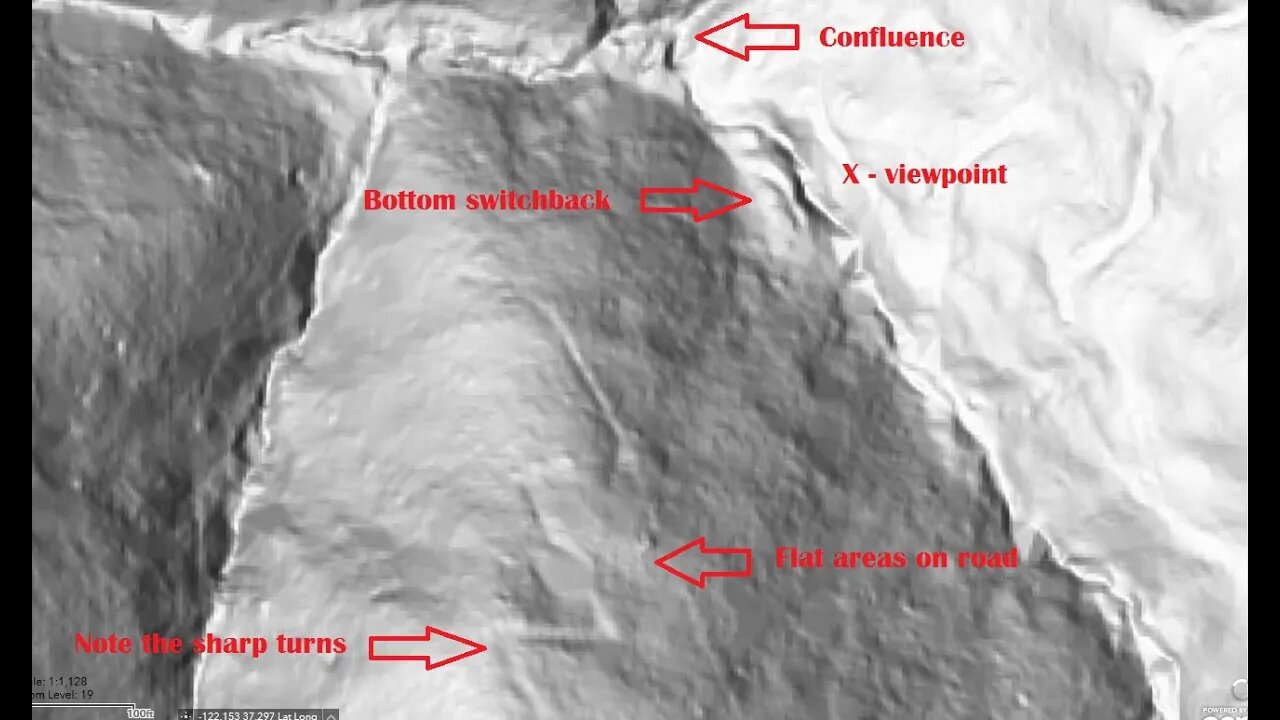
Another stop on a bike ride to check out an old road I saw near the middle of the Grizzly Flat / North Trail in Upper Stevens Creek County Park. After checking out the barbed wire fence remains, tried to make it down to the bottom of the Branch D canyon.
This road is very overgrown as it nears the bottom of the Branch D canyon due to the moist conditions. It seems there may have been an earlier road that made a large, sweeping turn and that may have slid out forcing a new road segment to be made. The newer road has very acute switchback turns that likely require backing down in a truck.
Also got to see the bottom of the old road that runs up the side of the ridge to Skyline Blvd. (Hwy. 35). I'll need to have a "live" hill shade map to explore more of this road as it's very faint in sections.
None of these roads appear on any maps. Grizzly Flat North Road first appears on the 1961 USGS topo map.
There appear to be at least 3 roads that come together at the bottom of the Branch D canyon. 2 of them seem to be quite old based on their minimal construction. Then this road seems more modern in terms of wider radius turns and that it joins up to an existing road. But then the question is, what was this built road for? Were the 2 older roads in the canyon still in use when this road was built? If not, then why did this road go down to the same area that the 2 old roads seem to meet up in? Maybe this road was abandoned when the county acquired this land for the county park in 1965.
It's about of a mile and 300 feet elevation drop (1.6km / 90m) from Grizzly Flat trail down to the bottom of the canyon on foot. Then it's a further 18.5 miles (30km) by bike on dirt and pavement to get here and back from home. Ends up being at least a 6 hour trip up here.
About the USGS HTMC:
https://www.usgs.gov/programs/national-geospatial-program/historical-topographic-maps-preserving-past
View/download maps on the TopoView site:
https://ngmdb.usgs.gov/topoview/
I used the 1897 Palo Alto quadrangle or the 1900 historical topo as listed in GaiaG:
https://www.gaiagps.com/
More to come...
Subscribe for more content like this
Comment, rate, share & click the bell icon
And as always, thanks for watching
#USGS #HillShade
-
 2:01:12
The Culture War with Tim Pool
3 hours agoNigeria's Christian Genocide, Media Ignoring Atrocities | The Culture War Podcast
119K59 -
 LIVE
LIVE
The Shannon Joy Show
1 hour agoKash Patel Doubles Down On Speech Control Opens The Door For Mass Censorship in America (Sponsored)
133 watching -
 LIVE
LIVE
ahdedazs
49 minutes agoBlack Ops 7 EARLY ACCESS BETA! Second Stream on RUMBLE! *NEW CREATOR*
140 watching -
 DVR
DVR
Side Scrollers Podcast
4 hours agoNetflix Execs to TESTIFY Over LGBTQ Agenda + IGN DESTROYS Xbox Game Pass + More | Side Scrollers
14.1K3 -
 1:06:22
The Quartering
1 hour agoAntifa Just Made A Huge Mistake...
70K39 -
 1:25:13
MattMorseTV
2 hours ago $5.45 earned🔴EMERGENCY White House PRESS CONFERENCE.🔴
16.6K13 -
 1:59:20
The Charlie Kirk Show
2 hours agoChristians Under Siege + Shame! Shame! + AMA | O'Neill, Ahern | 10.3.2025
70.4K14 -
 1:02:21
Dear America
2 hours agoEp 3 Graham Allen Show
25.7K9 -
 3:01:23
Right Side Broadcasting Network
5 hours agoLIVE REPLAY: White House Press Secretary Karoline Leavitt Holds a Press Briefing - 10/3/25
62.4K28 -
 1:46:35
Tucker Carlson
1 hour agoThe Occult, Kabbalah, the Antichrist’s Newest Manifestation, and How to Avoid the Mark of the Beast
18K11
