Looking for the 1948 Structures and Roads
A return trip to see if the old road seen on the USGS HillShade map could be used to access the bench to the east of the creek where 2 structures are shown on the 1948 topo map.
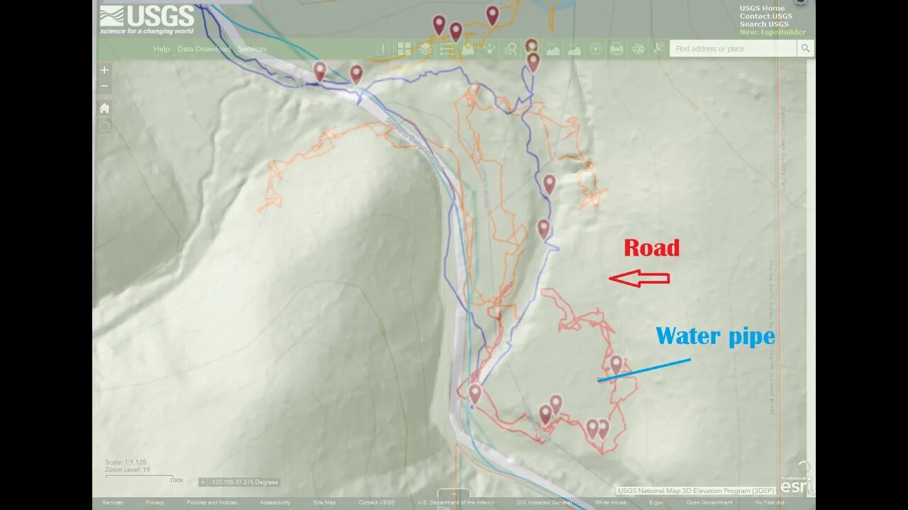
It does give access to the bottom end of the bench but heavy brush prevented going any farther up towards the pond area. There were signs of past activity here, an old fence and water pipe along with an old road cut along the foot of the canyon slope. Nice confirmation of being able to identify potential roads on the hill shade map and then being able to go out and find that road in real life.
Pretty slow going up in this area. A bit over an hour to go 0.32mi. or 0.5km. I might try again later this year when the water level drops in the creek like last October. That way, it's easier to move up/down the creek bed and then try accessing the bench from other locations.
Thumbnail image was an overlay of screen captures of the hill shade map and the GaiaG track done in Gimp. Was difficult to get a similar zoom level and get the 2 images to line up well.
USGS National Map Viewer:
https://apps.nationalmap.gov/viewer/
View/download maps on the TopoView site:
https://ngmdb.usgs.gov/topoview/
Subscribe for more content like this
Comment, rate, share & click the bell icon
And as always, thanks for watching
#USGS #HillShade
-
 LIVE
LIVE
JDubGameN
5 hours agoStarlink Network Test Stream! | Road to 100 Followers
916 watching -
 2:17:31
The Daily Signal
8 hours ago $8.32 earned🚨BREAKING: Tennessee Congressional Election Results, Minneapolis Police to "Intervene" Against ICE,
38.2K6 -
 1:52:47
megimu32
5 hours agoON THE SUBJECT: Christmas Vacation Is UNTOUCHABLE!
24K4 -
 59:56
59:56
Sarah Westall
6 hours agoNeurostrike, Cognitive Targeting & the New Tech Arms Race w/ Professor Armin Krishnan
18.9K4 -
 2:52:28
Nikko Ortiz
7 hours agoNo More Gear Fear... | Rumble LIVE
26.7K1 -
 5:00:51
Razeo
5 hours agoTopside carnage with some fries.,
14.7K -
 1:03:17
BonginoReport
8 hours agoViolent Criminals Run Free in NY & CA - Nightly Scroll w/ Hayley Caronia (Ep.188) - 12/02/2025
130K49 -
 6:33:02
The Rabble Wrangler
22 hours agoBattlefield with The Best in the West
12.6K -
 2:55:41
heathen_streamz
6 hours agoLet's get Bent in ARC RAIDERS | Happy Tiddy Tuesday!
13.1K -
 41:54
41:54
Katie Miller Pod
10 hours ago $6.45 earnedPete & Jen Hegseth on Family Values, Job Transition, & Military Readiness | KMP Ep. 17
30.8K9