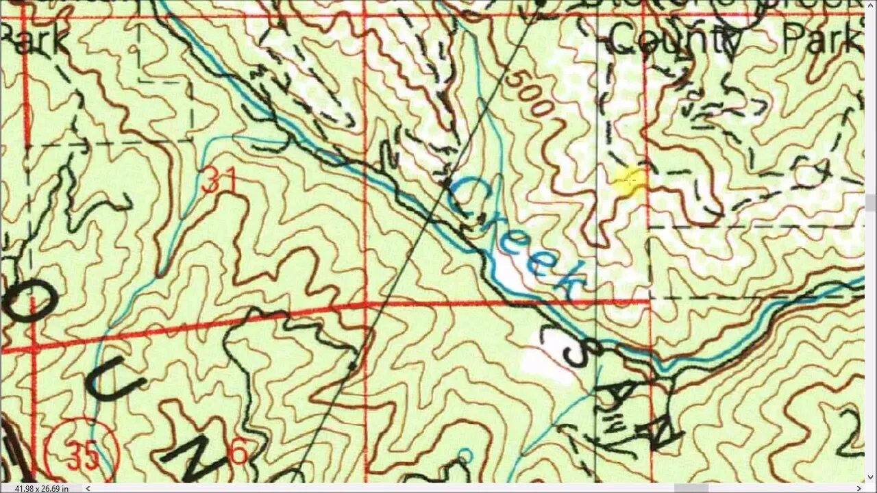
USGS Topo Maps: Changes Over Time
A deep dive into some tips and tricks I've found trying to make use of the USGS Historical Topo Maps as well as modern mapping/G apps while exploring Stevens Creek Canyon on on bicycle and on foot. Some might think a map is a map, who cares. If you think (Apple/Google/Bing/etc.) Maps is the be all and end all of maps, then you might want to skip this video.
From my experience, there's no "best" map or app for this kind of task. Rather there are many maps/apps all with pluses and minuses. They vary in what details they show, what time period they cover, and how they can be used out in the field with no data connection. In the end, you need to pull together bits and pieces from several maps/apps and then form a plan and go out and see what's actually out there. Then you may need to come back, gather up what you found and then maybe find something new out of another map and repeat the process.
I find this is a great way to get to know an area in depth. For years, I was riding up and down this road and it was just that part of the ride you had to grind through to get to the trails. But now, at every turn in the road, I can look over and see that there was an old structure there or an old road heading off here, etc. This is a great way to practice map reading, navigation, cross country hiking and G/app use. It's incredible when you can link up a historical map with modern G technology and see exactly where you are and navigate on that old map and look for roads and structures and then actually find them.
About the USGS HTMC:
https://www.usgs.gov/programs/national-geospatial-program/historical-topographic-maps-preserving-past
View/download maps on the TopoView site:
https://ngmdb.usgs.gov/topoview/
Subscribe for more content like this
Comment, rate, share & click the bell icon
And as always, thanks for watching
-
 LIVE
LIVE
SpartakusLIVE
7 hours agoSolos on ARC: UNBANNED
9,859 watching -
 30:29
30:29
Robbi On The Record
7 hours ago $0.49 earnedWhales Are Selling. Banks Are Nervous. Bitcoin analysis ft Simply Bitcoin Tv
5.28K4 -
 2:28:12
vivafrei
14 hours agoEp. 291: More Epstein Documents! Stacey Plaskett SCANDAL! Butler Cover-Up, Tucker Smea & MORE!
196K218 -
 6:06:22
xLuigi34x
6 hours ago100 Follower Special! Going to 100% The DKC Trilogy on stream!
40.7K2 -
 50:27
50:27
Sarah Westall
4 hours agoMusk Helps Expose the Most Consequential Political Blackmail Operation in Modern British History
22.8K10 -
 4:52:47
Due Dissidence
13 hours agoTrump GOES NUCLEAR on MTG, Tucker Exposes Butler COVERUP, Shmuley SUED For HILARIOUS Reason
36.9K17 -
 20:13
20:13
RealReaper
8 hours ago $1.36 earnedPredator Badlands: If You Like This Movie Then I Hate You
22.8K16 -
 LIVE
LIVE
GritsGG
6 hours ago#1 Most Warzone Wins 4000+!
296 watching -
 41:54
41:54
Nicholas Bowling
7 hours ago $1.51 earnedWhile Preaching to Muslims, EX-MUSLIM Shares Why He Left Islam (London, UK)
23.9K10 -
 2:25:28
bucketofish
5 hours agoNoise Floor \\ Behind the Mix - Ep 002 - Wide Awake by Katy Perry
28.3K1