Premium Only Content

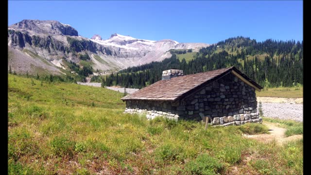
Mt Rainier - Panhandle Gap, Indian Bar Hiking
Wire - Villain Plays The Victim
Awesome Mt. Rainier Hiking
Hard Rockin' Song
Wire - Villain Plays The Victim
Mount Rainier is a large active stratovolcano in the Cascade Range of the Pacific Northwest. The mountain is located in Mount Rainier National Park about 59 miles (95 km) south-southeast of Seattle. With a summit elevation of 14,411 ft (4,392 m), it is the highest mountain in the U.S. state of Washington and the Cascade Range, the most topographically prominent mountain in the contiguous United States, and the tallest in the Cascade Volcanic Arc.
Due to its high probability of eruption in the near future, Mount Rainier is considered one of the most dangerous volcanoes in the world (Bull crap scare tactic), and it is on the Decade Volcano list. The large amount of glacial ice means that Mount Rainier could produce massive lahars that “could” threaten the entire Puyallup River valley.
Between 1950 and 2018, 439,460 people climbed Mount Rainier.
The Wonderland Trail is an approximately 93-mile (150 km) hiking trail that circumnavigates Mount Rainier in Mount Rainier National Park, Washington, United States. The trail offers spectacular unique views on a daily basis and goes over many ridges of Mount Rainier for a cumulative 22,000 feet (6,700 m) of elevation gain. The trail was built in 1915. In 1981, it was designated a National Recreation Trail. An estimated 200 to 250 people a year complete the entire trail with several thousand others doing shorter sections of it. The average time taken to complete the entire trip is 10 to 14 days.
Longmire
Sunrise
Mowich Lake
White River
Summerland
Indian Bar
Nickle Creek
Reflection Lakes
Indian Henry’s
Emerald Ridge
South Puyallup
Spray Park
Grand Park
Devil’s Dream
Windy Gap
Northern Loop
Mowich River
Golden Lakes
Kautz
South Tahoma-Tahoma
Puyallup
North Mowich
Summit
Carbon
Winthrop
-
 0:09
0:09
bojan_dukovski
3 years agoHiking
15 -
 0:44
0:44
JhessBats
3 years agoHiking
5 -
 1:58:04
FreshandFit
4 hours agoWhy Women Are Always Single?
63.6K15 -
 1:12:39
Man in America
11 hours agoThe Frightening Truth About Weather Warfare & Depopulation w/ Kim Bright
96K42 -
 2:59:21
TimcastIRL
5 hours agoTrump Calls Epstein Case A HOAX By Democrats, GOP Votes TO BLOCK Release | Timcast IRL
212K223 -
 10:17
10:17
Dr Disrespect
14 hours agoIt's Time To Get Serious
19.8K9 -
 LIVE
LIVE
SpartakusLIVE
7 hours agoDuos w/ Sophie || Charity stream tomorrow!
617 watching -
 58:43
58:43
Sarah Westall
6 hours agoBecause Voluntary Extermination is a Thing: Israel-Gaza w/ Award Winning Journalist James Robins
36.6K10 -
 LIVE
LIVE
BubbaSZN
7 hours ago🔴 LIVE - TRYING TO NOT BUST A$$ THIS TIME (THPS3+4)
348 watching -
 8:42:11
sophiesnazz
10 hours ago $1.56 earnedGENUINE BELTERS IN ERE l LIVE WITH @SpartakusLIVE!socials
35.2K1