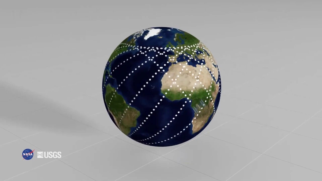
Why does the GEDI orbit footprint look the way it does?
Why does the GEDI orbit footprint look the way it does? GEDI produces high resolution laser ranging observations of the Earth's forests and topography. GEDI was deployed to the International Space Station in 2018, and captures data along the ISS orbit shown here. When viewed in two dimensions, the ISS orbit resembles a net of offset waves This animation shows a full GEDI orbit footprint from early 2019. The ISS orbit defines GEDI coverage between 51.6 degrees, north and south. The LP DAAC is one of the NASA Earth Observing System Data and Information System (EOSDIS) DAACs and operates as a partnership with the United States Geological Survey (USGS). It is located at the USGS Earth Resources Observation and Science (EROS) Center in Sioux Falls, South Dakota.
Subscribe now for more videos from over 280 sources plus my own videos!
Subscribe to my entertainment channel too or at least peek at my other channel !!! https://www.youtube.com/channel/UCiNFsoytAuun90UzU5AuxXg
https://www.bitchute.com/channel/YsJ0PYUWx5An/
https://www.patreon.com/user?u=26453564
-
 13:25
13:25
Kurt's News
4 months agoCNN Host BUSTED Lying & Rewriting History on White SA Farmers
100 -
 2:58
2:58
From Zero → Viral with AI
20 hours agoAI Isn’t Ruining Politics — It’s Revealing the Truth.
21 -
 LIVE
LIVE
MattMorseTV
3 hours ago $37.34 earned🔴Portland Antifa's LASER ATTACK.🔴
4,326 watching -
 LIVE
LIVE
megimu32
2 hours agoOFF THE SUBJECT: SAVAGE SATURDAY | Bodycam Chaos & Fortnite Madness!
171 watching -
 DVR
DVR
Mally_Mouse
23 hours ago🌶️ 🥵Spicy BITE Saturday!! 🥵🌶️- Let's Play: Content Warning
24.7K2 -
 18:17
18:17
JohnXSantos
1 day ago $0.05 earned$1 vs $1,000,000,000 Business!
2.15K -
 3:11
3:11
Memology 101
18 hours ago $2.39 earnedDon Lemon DESTROYED by LEGAL immigrants after claiming crossing the border illegally ISN'T a crime
12.4K26 -
 1:32:31
BooniesHQ
8 hours ago $14.15 earnedGame Of SKATE Jereme Rogers Vs. Jordan Maxham: Boonies Skate Night 3
121K14 -
 15:23
15:23
Exploring With Nug
14 hours ago $4.59 earnedWe Went Scuba Diving in the River and Found Incredible Lost Relics!
26.1K2 -
 6:48:07
Rallied
9 hours ago $13.17 earnedBATTLEFIELD 6 DOMINATION WITH RAL !BF6 #BF6 #Ad
111K8