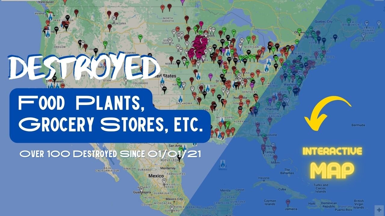
+100 Food Processing Plants & Grocery Stores Destroyed - (interactive map)
TIME FRAME: 01/01/2021 – 06/20/2022
REASONS: Fire/Explosion, Disease, Permanently Closing, Vandalism, Hacked & Government Ordered
PROOF: Attached to each pin on the map has the Name, Location, Date, Reason & a Link to each article/video/news story (this is so they cannot explain it away)
TRENDS: Most buildings are either damaged or completely destroyed by fires or explosions, in the middle of the night & have no reason regarding what started the fire.
See below for the list of colors and what each one represents. The greenhouse, chemical plants, or food recalls are not yet included on this map.
BLACK – PLANT
BROWN – GRAIN/SILOS
FUSCIA – HACKED – Any company that produces food/gas/electricity/water that is hacked
GREEN – FARMS/ANIMALS
PURPLE – FOOD PANTRY
RED – GROCERY STORE
WHITE – DESTROYED/EUTHANIZED/BANNED (Any food that is destroyed and/or banned OR when animals are euthanized due to disease)
INTERACTIVE MAP:
---
https://www.zeemaps.com/view?group=4410859&x=-89.849631&y=44.059004&z=14
Curated by:
https://theaquariusbus.com
-
 31:01
31:01
The Aquarius Bus
2 months agoExquisite Old World Philadelphia. Founded 1682. Why Did They Move The Capital to DC?
1.08K7 -
 2:05:07
Darkhorse Podcast
1 day agoWhy Trump Wants Greenland: The 257th Evolutionary Lens with Bret Weinstein and Heather Heying
277K438 -
 8:50:58
Right Side Broadcasting Network
1 day ago🎅 LIVE: Tracking Santa on Christmas Eve 2024 NORAD Santa Tracker 🎅
302K42 -
 2:48
2:48
Steven Crowder
1 day agoCROWDER CLASSICS: What’s This? | Nightmare Before Kwanzaa (Nightmare Before Christmas Parody)
292K12 -
 33:49
33:49
Quite Frankly
23 hours agoThe Christmas Eve Midnight Telethon
102K22 -
 2:12:46
Price of Reason
22 hours agoAmber Heard BACKS Blake Lively Lawsuit Against Justin Baldoni! Is Disney CEO Bob Iger in TROUBLE?
56.9K23 -
 1:01:17
The StoneZONE with Roger Stone
17 hours agoChristmas Edition: Why the Panama Canal is Part of the America First Agenda | The StoneZONE
127K47 -
 18:12:15
LFA TV
1 day agoLFA TV CHRISTMAS EVE REPLAY
142K18 -
 13:32
13:32
Scammer Payback
18 hours agoChanging the Scammer's Desktop Background to his Location
12.2K3 -
 4:21
4:21
BIG NEM
20 hours agoNikola Tesla's Secret to Cultivating Creativity & Genius
8.76K1