Satellite imagery shows destroyed bridges near Sievierodonetsk
3 years ago
279
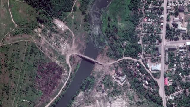
Satellite imagery from Maxar Technologies collected on Saturday (June 11) showed damaged bridges around the eastern Ukrainian city of Sievierodonetsk. The images, which were released on Tuesday (June 14), displayed a number of destroyed and damaged bridges which link Sievierodonetsk to the nearby towns of Rubizhne and Lysychansk.
Loading 1 comment...
-
 1:57
1:57
Reuters
11 hours agoPutin appears to shrug off Trump deadline on Ukraine
3684 -
 2:20:51
TheSaltyCracker
3 hours agoTime To Arrest Hillary ReEEeStream 8-01-25
33K119 -
 LIVE
LIVE
SynthTrax & DJ Cheezus Livestreams
12 hours agoFriday Night Synthwave 80s 90s Electronica and more DJ MIX Livestream Variety Visuals / Variety Tracks Edition
282 watching -
 1:46:59
Glenn Greenwald
6 hours agoNew Russiagate Disclosures Show Depths of CIA & FBI Guilt; Trump Forcing Universities to Adopt DEI Programs Only for Jewish Students; The "Pogrom" at FSU | SYSTEM UPDATE #496
65.1K47 -
 LIVE
LIVE
FusedAegisTV
22 hours agoOFFICIAL Evo 2025 Day 1 Co-Stream - Las Vegas, NV ∥ 17 TOURNAMENTS!!
244 watching -
 2:10:07
The Illusion of Consensus
3 hours agoDEBATE: Alex Berenson vs Dave Smith on Holocaust, Israel/Gaza
31.5K5 -
 8:07
8:07
MattMorseTV
1 day ago $9.73 earnedTrump just LOWERED PRICES by 75 PERCENT.
62.8K99 -
 51:41
51:41
BonginoReport
11 hours agoParalyzed Woman Blames COVID-19 Jab, Sues Moderna! - Nightly Scroll w/ Hayley Caronia (Ep.103)
121K79 -
 2:08:34
Mally_Mouse
1 day agoFriend Friday!! - Let's Play! - Minecraft
8.21K -
 LIVE
LIVE
Gore TV
2 hours ago💀 STAY DOWN, BRO 🤣 | Vapingamers Needs a Rez… Again 😏
31 watching