Satellite Photos from Donbas and Kharkiv Region Show MLRS, Artillery and Shelling - From 6th June
A little video here looking at a few satellite photos that were posted today. These were taken in the Donbas region, near Seveerodonetsk. They don’t show too much, but give an idea of Russia’s firing locations and deployment. The photos were shared by Maxar Technologies and were taken on the 6th June.
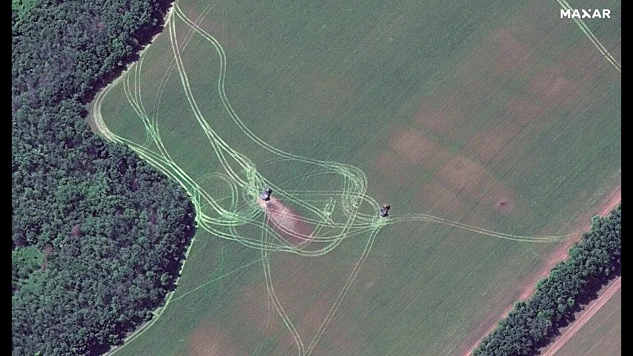
So, the first image here shows a pair of MLRS units. Maxar provided coordinates too, which lets us see the location of the units on Google Maps. So, they are located north of Severodonetsk. And approximately 10.78 kilometers north of the Mir Hotel in Severodonetsk.
The next image shows towed guns—again aimed at severodonetsk. There are three shown, surrounded by sandbags as protection for the crew from coutnerfire.
Also present, and now circled—a supply truck. Hidden in a cluster of trees, but still visible for satellites.
These artillery pieces are 8.66km north of Severodonetsk northern edge. But, their orientation appears to be aiming at the western side of the city. As shown here.
Finally, this image shows the impact of shelling at Dolyna. There are manyc raters from past barrages, and plumes of smoke from current and more recent impacts.
To the north, is this little structure here with a cell or radio tower. The building is damaged, but the tower remains.
On the road, in this image—there appears to be a truck or other vehicle. I can’t see any other vehicles or military emplacements in the area.
The coordinates given show that Dolyna is on the main road between Russian occupied Izyum and Ukrainian held Slovyansk—a key target for Russia.
Another image—this shows artillery fire along the Seversky Donets River. At a town called Bohorodychne. The bridge crossing the river is down. This town is not far from Dolyna.
This image shows fields absolutely riddled with artillery craters. No military vehicles present from what I cans ee—destroyed or otherwise. There is no incoming fire either shown. It could be that anything hit has already been carted away. The coordinates give its position here—west of Dolyna.
Finally, we have this image of a massive 40-meter crater in Dovhenke. This could be the result of this explosion from May 11 at an ammonium nitrate warehouse.
So, that’s it for the satellite images. Some quite interesting things shown. Nothing too ground breaking, but still worth a look. If you could like the video and subscribe, I would appreciate it.
-
 2:11
2:11
Suchomimus
2 years agoBM-21 Grad Destroyed
6573 -
 LIVE
LIVE
Game On!
16 hours ago10,000 Followers Celebration Stream! Let's Talk Sports!
4,031 watching -
 LIVE
LIVE
JuicyJohns
13 minutes ago🟢#1 REBIRTH PLAYER 10.2+ KD🟢$500 GIVEAWAY
175 watching -
 15:38
15:38
SKAP ATTACK
18 hours ago $0.90 earnedA Legacy Tainted: Unpacking the LeBron Steroid Rumors
13.8K7 -
 2:04:52
The Confessionals
20 hours agoThe Great Spiritual Hijack — And Why It’s Ending
10.9K6 -
 1:49:30
Nick Freitas
14 hours agoHere's Why The Housing Market Is Permanently Broken
13.8K2 -
 17:03
17:03
Nicholas Bowling
18 hours ago $0.32 earned"Celebrity" Tells Street Preacher His Dad's in the ILLUMINATI
3.93K2 -
 LIVE
LIVE
BEK TV
21 hours agoTrent Loos in the Morning - 7/30/2025
145 watching -
 4:10
4:10
Blackstone Griddles
13 hours agoCajun Dogs with Bruce Mitchell
3.9K1 -
 29:38
29:38
Uncommon Sense In Current Times
14 hours ago $0.20 earnedIs Doubt a Sin? Wrestling with Faith & Belief (Part 1) | Dr. Randal Rauser
10K5