Premium Only Content

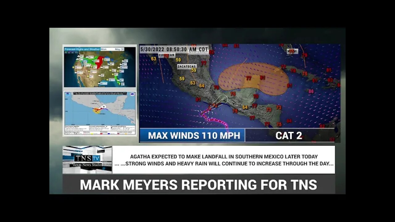
HURRICANE AGATHA HAS WINDS OF 110 MPH-WILL MAKE LANDFALL LATER TODAY IN SOUTHERN MEXICO
BULLETIN
Hurricane Agatha Intermediate Advisory Number 10A
NWS National Hurricane Center Miami FL EP012022
700 AM CDT Mon May 30 2022
...AGATHA EXPECTED TO MAKE LANDFALL IN SOUTHERN MEXICO LATER
TODAY...
...STRONG WINDS AND HEAVY RAIN WILL CONTINUE TO INCREASE THROUGH THE
DAY...
SUMMARY OF 700 AM CDT...1200 UTC...INFORMATION
----------------------------------------------
LOCATION...15.1N 97.3W
ABOUT 65 MI...110 KM SW OF PUERTO ANGEL MEXICO
MAXIMUM SUSTAINED WINDS...110 MPH...175 KM/H
PRESENT MOVEMENT...NE OR 55 DEGREES AT 6 MPH...9 KM/H
MINIMUM CENTRAL PRESSURE...964 MB...28.47 INCHES
WATCHES AND WARNINGS
--------------------
CHANGES WITH THIS ADVISORY:
None
SUMMARY OF WATCHES AND WARNINGS IN EFFECT:
A Hurricane Warning is in effect for...
* Salina Cruz to Lagunas de Chacahua
A Hurricane Watch is in effect for...
* Salina Cruz eastward to Barra De Tonala
A Tropical Storm Warning is in effect for...
* Salina Cruz eastward to Boca de Pijijiapan
* Lagunas de Chacahua westward to Punta Maldonado
A Hurricane Warning means that hurricane conditions are expected
somewhere within the warning area.
A Hurricane Watch means that hurricane conditions are possible
within the watch area.
A Tropical Storm Warning means that tropical storm conditions are
expected somewhere within the warning area.
Interests elsewhere in southern Mexico should closely monitor the
progress of Agatha.
For storm information specific to your area, please monitor
products issued by your national meteorological service.
DISCUSSION AND OUTLOOK
----------------------
At 700 AM CDT (1200 UTC), the center of Hurricane Agatha was located
near latitude 15.1 North, longitude 97.3 West. Agatha is moving
toward the northeast near 6 mph (9 km/h), and this general motion is
expected to continue through Tuesday. On the forecast track, the
center of Agatha will make landfall in the state of Oaxaca, Mexico,
this afternoon or this evening.
Maximum sustained winds remain near 110 mph (175 km/h) with higher
gusts. Little change in strength is expected today before Agatha
reaches the coast of Oaxaca. Rapid weakening is expected after
landfall, and Agatha is forecast to dissipate over southeastern
Mexico by late Tuesday.
Hurricane-force winds extend outward up to 15 miles (30 km) from
the center and tropical-storm-force winds extend outward up to 90
miles (150 km).
The estimated minimum central pressure is 964 mb (28.47 inches).
HAZARDS AFFECTING LAND
----------------------
WIND: Hurricane conditions are expected in the hurricane warning
area and possible in the watch area by this afternoon. Tropical
storm conditions have begun along the coast of Oaxaca and will
spread eastward within the warning area through the day.
STORM SURGE: Storm surge is expected to produce extremely dangerous
coastal flooding in areas of onshore winds near and to the east of
where the center of Agatha makes landfall. Near the coast, the
surge will be accompanied by large and destructive waves.
RAINFALL: Agatha will produce heavy rains over portions of southern
Mexico through Tuesday night. The following rainfall amounts are
currently expected:
Mexican state of Oaxaca: 10 to 16 inches, with isolated maximum
amounts of 20 inches possible. Life-threatening flash flooding and
mudslides may occur.
Mexican state of Chiapas: 5 to 10 inches, with isolated maximum
amounts of 15 inches possible. Life-threatening flash flooding and
mudslides may occur.
Mexican states of Veracruz, Tabasco and eastern portions of
Guerrero: 2 to 4 inches, with isolated maximum amounts of 6 inches
possible.
SURF: Large swells generated by Agatha will affect the coast of
southern Mexico during the next day or two. These swells are
likely to cause life-threatening surf and rip current conditions.
Please consult products from your local weather office.
NEXT ADVISORY
-------------
Next complete advisory at 1000 AM CDT.
$$
Forecaster Cangialosi
-
 2:36:28
I_Came_With_Fire_Podcast
13 hours agoObama's Treason, Trade War: Season Infinity, and Hunter's Pipe Dream
20.2K1 -
 2:52:51
TimcastIRL
6 hours agoObama Referred To DOJ For TREASON, Criminal Investigation, CIVIL WAR!! | Timcast IRL
217K121 -
 9:43:32
RalliedLIVE
13 hours ago $6.04 earned10 WINS WITH THE SHOTTY BOYS
100K7 -
 1:35:43
Badlands Media
17 hours agoAltered State S3 Ep. 38: Biolabs, Bitcoin & the Epstein Data Vault
58.8K14 -
 LIVE
LIVE
SpartakusLIVE
5 hours agoLAST Stream Until NEXT WEEK || Going to Florida to hang out w/ a SPECIAL Gaming Buddy
243 watching -
 10:19
10:19
MattMorseTV
1 day ago $11.34 earnedTrump just went SCORCHED EARTH.
73.1K63 -
 1:36:49
RiftTV
7 hours agoHow Much is the Government SPYING on You and STEALING Your DATA?! | Almost Serious | Guest: Matt Kim
35.9K4 -
 1:31:26
Glenn Greenwald
8 hours agoAaron Maté on More Russiagate Fallout, Protests in Ukraine, and Israel's Strikes on Syria With Special Guests John Solomon, Marta Havryshko, and Joshua Landis | SYSTEM UPDATE #491
122K45 -
 1:55:43
Melonie Mac
8 hours agoGo Boom Live Ep 56!
35.5K7 -
 1:55:44
Joker Effect
5 hours agoWHY AREN'T YOU DOING THE RUMBLE CREATOR PROGRAM...? IT BEGINS HERE. Wake up!
11.4K2