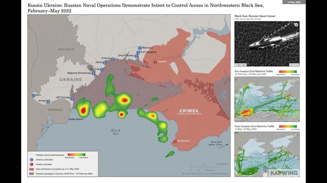
Russia's Blockade of the Black Sea
Satellite imagery showing Russia's blockade of the black sea near Ukraine and the extent of Russian Naval activity.
A little video here about Russia’s control of the Black Sea. I saw this image shared on twitter and is from US Navy intelligence. Now, the image quality wasn’t great to beging with—and I expect it will drop in quality once uploaded. But hopefully it is clear enough.
So, basically this shows the overall control of the northern Black Sea, current trade and traffic routes and areas of Russian activity.
So, the striped pattern is water where Russia is denying access to shipping—they have basically cut off the entire coastline of Ukraine. The green blotches are areas of density of Russian naval activity—we will get into that shortly.
First of all, I want to look here. So, at the top we have civilian maritime traffic on February 14 to February 15---a high density of civilian activity around Ukraine’s ports of Odesa and Yuzhny and Mykolaev.
Then, if we look at 17-18 of May—gone. There is no civil traffic in Ukraine. The country is entirely cut off from coastal trade routes. This has led to 20 million tons of wheat stuck in Ukraine and this will have a wide-sweeping effect. Not just in the west. The EU said bread prices in Lebanon have increased 70 percent for example. There are calls for NATO and the west to break the blockade—Russia is trying to negotiate lifting of sanctions. But I think it is better to look for an economist or other export to get the ins and outs of Russia’s blockade and its effects on trade and what not.
But it’s one of the main reasons that Ukraine needs long-range anti-ship missiles sent. Denmark apparently plans to send Harpoons and a launcher. Britain agreed to send Harpoons—but I think it will take a while to train them and the British ones need integrating onto a suitable platform as they are ship-launched.
Now, back to the areas of Russian activity. First of all—Snake Island. Thisd is a key spot for control of the Northern Black Sea. It can be used a staging base for small patrol and attack ships—such as the raptor. It can be used to station SAMs—which we have seen Russia do. At the moment, short range SAMs like the Pantsir have been shown there, but if Russia stations a long range SAM it will allow them a lot of air coverage. It could also—if Ukraine captures it—be used a platform for anti-ship missiles. This will be risky---it’s vulnerable to air attack. But putting a missile like the Neptune on here will greatly increase where Ukraine can hit in the Black Sea.
Away from Snake Island—we can see a lot of action in the cenral Black Sea. Some of this will be regular patrols duties—but I suspect that the igh-density areas, in red, are possibly where Russia is launching its sea-based cruise missiles from.
Finally, along the coast of Crimea, we see a lot of activity. Some of this I believe will be regular patrols along the coast. We have also seen that Russia carries out training and practices there. But again, this area could be a Kalibr launching point. Kalibr has a range of between 1,500 to 2,500 kilometers. More than enoigh range to strike targets in Ukraine without the need to get ships and submarine closer to the Ukrainian mainland.
-
 2:11
2:11
Suchomimus
2 years agoBM-21 Grad Destroyed
6563 -
 DVR
DVR
RiftTV
3 hours agoCON INC: We Should All Just FORGET About Epstein | The Rift | Dinesh D’Souza, Lauren Witzke + More
14.8K1 -
 LIVE
LIVE
AlaskanBallistics
5 hours agobest .22lr Suppressor
33 watching -
 LIVE
LIVE
RalliedLIVE
6 hours ago $1.00 earned10 WINS WITH THE SHOTTY BOYS
98 watching -
 LIVE
LIVE
LIVE WITH CHRIS'WORLD
2 hours agoLIVE WITH CHRIS’WORLD - I Have So Many Questions Right Now
98 watching -
 LIVE
LIVE
SpartakusLIVE
2 hours agoWZ Solos || GCX St. Jude Charity Marathon @ 8PM EST
35 watching -
 LIVE
LIVE
FrizzleMcDizzle
2 hours agoTIKTOK BANNED ME LOL - Clair Obscure: Expedition 33
85 watching -
 58:21
58:21
BonginoReport
4 hours agoTrump Deepens MAGA’s Epstein Divide - Nightly Scroll w/ Hayley Caronia (Ep.91) - 07/16/2025
126K82 -
 LIVE
LIVE
GoodLifeGaming
4 hours ago🔴LIVE - DAY 2 - NEW PLAYER TRIES DESTINY 2 - PVP AND POWER GRINDING ALL DAY - ADVICE WELCOME!
16 watching -
 LIVE
LIVE
The Rabble Wrangler
18 hours agoRimworld with The Best in the West!
20 watching