

Bicycling Chambers Bay Tacoma Washington
Chambers Bay, located in Tacoma Washington, is a world-class 18-hole championship golf course. In 2010 Chambers Bay hosted the U.S. Amateur and in 2015 the U.S. Open. The total area is 950 acres with a nice trail system encircling the property, 3.5 miles. It's great for walking, running and bicycling with spectacular views.
8
views
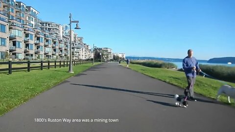
Bicycling Ruston Way
Join us as we bicycle this historic area. Ruston Way is located in Tacoma, and Ruston Washington. In the 1800's the Ruston Way area was a mining town. In 1888 a smelter was built to extract the metals from the ore. William Rust was overseeing the smelter, the growing town was named after him, Ruston. In 1985 the EPA closed the smelter due to the contamination caused from the smelting process. In 1993 the smelter plant was demolished. A developer, Point Ruston LLC, purchased the land and took on the responsibility to remediate the land. In 2006 the development project began. Now the area is cleaned, an array of condo's, apartments, shops, restaurants and recreational activities are throughout the newly constructed complex.
1
view
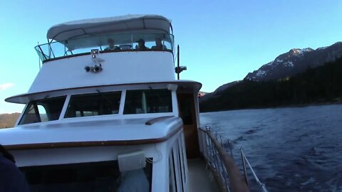
Bleu Wave Sunset Cruise Lake Tahoe
Take a sunset cruise onboard the Bleu Wave out of South Lake Tahoe. The yacht is 70-feet long and holds up to 47 people. The cruise takes you out to Emerald Bay, Lake Tahoe's crown jewel. Pass by Fannette Island, where Lora Knight built a teahouse resembling a castle in 1929. Additionally, she had the Vikingsholm Castle built along the mainland beach area, a 39-room mansion of Scandinavian design.
6
views
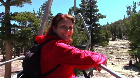
South Lake Tahoe Gondola Ride
Experience the ride up and down the gondola and chairlift at South Lake Tahoe, California. The views are awesome of nearby snowcapped mountains and the vastness of Lake Tahoe. Experience the uniqueness of the California and Nevada State's line, it took some 100 years to resolve the boundary dispute which finally got settled in 1980. Take a glimpse of the activities at 9150 feet, there's a roller coaster, beautiful lodge, numerous hikes and vantage points. The ride up is just over 2 miles that takes some 10 minutes. Well worth the experience. For the die-hard, you can hike up and take the Gondola down.
5
views
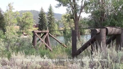
Menors Ferry Grand Teton National Park
Menors Ferry is located north of Jackson Hole, Wyoming in the Grand Teton National Park. Bill Menor left Ohio and settled at the present location along the Snake River in 1892. He built his cabin, a general store and a ferry to cross the Snake River. His brother lived across the river and built a limekiln operation. In 1918 Bill sold his operation to Maud Noble. Maud had her cabin relocated to the property, set up a meeting with the local prominent individuals which launched the Grand Teton National Park. An Episcopal church was built in 1925 called the Chapel of Transfiguration. It offered spiritual refreshment for the dude ranchers and visitors. Currently there are services held on Sunday's during the summer months.
8
views
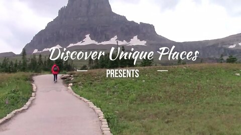
St Mary Falls Trail Glacier National Park
St Mary Falls is located on the east side of Glacier National Park, Montana. The Park can get very busy, therefore, it's best to take advantage of the Shuttle. The Shuttle requires a reservation so check the Parks website. The St Mary Falls Trail can get very busy, so extend your hike from the Siyeh Bend Shuttle drop off to the Sun Point drop off. It's approximately 5 miles with a gradual downhill. You will cross Reynolds Creek, pass through the Reynolds Creek Fire area of 2015, visit St Mary Falls and make your way to St Mary Lake.
11
views
Bill Williams National Wildlife Refuge, Arizona
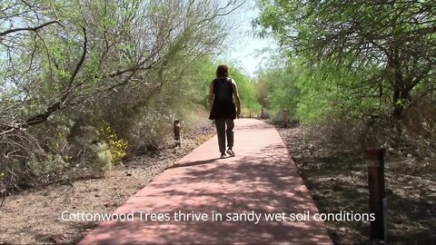
The Bill Williams National Wildlife Refuge is located 17 miles south of Havasu City, Arizona. Named after the early frontiersman and explorer, Bill Williams. In 1993 6,100 acres of the Havasu Lake National Wildlife Refuge was designated as Bill Williams National Wildlife Refuge. The Refuge is home to 700 species of birds, 220 species of mammals, 250 reptilian and amphibian species and 200 species of fish. It also serves as the resting and breeding grounds for migratory birds. There's a 1-mile, round trip trail that goes through a small Cottonwood Tree Forest, interpretative panels, restrooms, cabanas, 3-fishing piers
, benches and a host of native plants. It's an oasis in the desert.
13
views
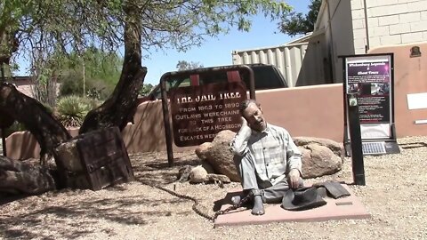
Wickenburg Arizona - The Desert Caballeros
Wickenburg, Arizona shows off its western heritage with the annual 5-day trail ride. Hundreds of horses and riders participate ending the trail ride in Wickenburg. This is the 75th annual ride. The western heritage is kept alive in Wickenburg.
3
views

Sonoran Loop Competitive Track, Arizona
White Tank Mountain Regional Park, Arizona, has a Competitive Track, a number of trails, that are geared for fast pace, challenging, and strenuous. They are a series of trails that interconnect allowing for a number of loops from easy to difficult. It's multi-use, cross country runners, joggers, bicyclists, and horseback riding. One can meander the trails totaling a distance of some 10-miles or take shorter loops.

Hassayayampa River Preserve Wickenburg, AZ
Hassayayampa River Preserve is located near the town of Wickenburg, Arizona. Native American Indians lived, hunted and grew corn on the banks of the stream (river). In the 1800's the area became known as the Wickenburg Dude Ranch, or "The Garden of Allah". In 1987 the area became the Preserve. Cottonwood trees dominate the area. The seeds germinate in the wet sediment. Where the soil deposits are thick then Mesquite grow. The Preserve is part of the Maricopa County Parks; therefore, there is a fee. If you are planning on returning or visiting the other Maricopa County Parks, its recommended to purchase an annual pass.
4
views

White Tank Mountain Regional Park Arizona...From Above
The White Tank Mountain Reginal Park is situated in Maricopa County, Arizona. The Park is composed of desert and mountainous terrain encompassing some 29,271 acres with approximately 26 miles of hiking trails (you can bring your dog too). Some of the trails are accessible by bicycle and/or horses. There are campgrounds, picnic areas and restrooms. There's an Interpretative Nature Center adjacent the Park's entrance. There's also an admission fee, an annual pass is the most cost-effective allowing access to all of the Regional Parks.
4
views

White Tank Waterfall Trail Arizona
White Tank Waterfall Trail is located in the White Tank Mountain Regional Park, Arizona. The trail is easy, 1.9-mile round trip with a part of the trail paved and another part is gravel. The trail is wide and easy walking, with an elevation gain of 351 feet. The last portion of the trail, leading into the canyon where the falls are, has a few stairs. Water flows after a recent rain. The area was once home to the Hohokam natives, they lived in the area up until about 1400 AD. Along the hike are some petroglyphs on the rocks. It's estimated that they are at least 3000 years old, perhaps older.
14
views

Eastrail - Newcastle Beach
Eastrail from Newcastle Beach to Mercer Slough, Seattle, WA area. There's approximately 42 miles of trails that connects a variety of communities. The Mercer Slough trail connects to Mercer Island and to Seattle. The Mercer Slough is named after a famous pioneer, Asa Mercer. He is known for bringing single young women from the East Coast in 1864 to the Seattle area for the single men, known as the Mercer Girls. A TV program, "Here Come The Brides" 1968 - 1970, was a spin-off from the Mercer Girls.
24
views
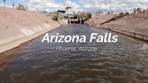
Arizona Falls Phoenix, Arizona
Arizona Falls was part of the canal system completed in 1885 which is now approximately 50 miles in length. A power plant was constructed at the falls in 1902, the first hydroelectric powerplant in in Phoenix. The canal was initially host to 1800 fruit trees and a 9-hole golf course. Currently there's a nice trail system adjacent the canal; the City of Scottsdale is approximately 2-miles.
48
views
Hidden Lake Trail Glacier National Park
At the top of Logan Pass, Glacier National Park, the Hidden Lake Trail climbs through alpine meadows, the "Hanging Gardens", crossing the Continental Divide. A three-mile round trip, with boardwalks through the meadows allows hikers stunning views of the scenery and wildlife. Parking at the Logan Pass Visitors Center can be a challenge, get there early. The trail is very popular.
14
views
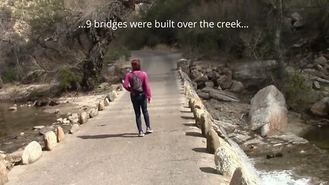
Sabino Canyon - Arizona
1930's, during the Great Depression, the Civilian Conservation Corporation built a road with 9 bridges up Sabino Canyon, just outside of Tucson Arizona. The road is 3.7 miles long and is only useable by foot, fee-based tram or bicycle after 5 pm. Sabino Creek has water flowing on the surface nearly year-round, some parts of the year the creek runs underground. Sabino Canyon is located in in the Santa Catalina Mountains, a part of the Sonoran Desert. The mountains began forming 12 million years ago. The Saguaro cactus began growing in the canyon about 8000 years ago. The trees began growing about 4000 years ago. The local Hohokam people lived in the canyon between 300 to 1400 AD.
3
views
Verrado Arizona From Above
Verrado is a community nestled at the base of the White Tank Mountains, 25 miles west of Phoenix in the City of Buckeye, Arizona. The Main Street District features the old town America, with shopping and restaurants. Verrado homes radiate outward from the Main Street District, the design of the neighborhoods was based on the early 20 Century neighborhoods. There are 78 uniquely designed parks for each neighborhood, swimming pools, golf and a host of trails. The White Tank Mountains are the backdrop, getting its name from a natural white granite basis, or tank, with water throughout the year. The cliffs surrounding the "tank" collapsed between 1898 and 1902 ending the watering hole. The exact location of the "Tank" is a mystery.

Flaming Geyser Auburn Washington
Flaming Geyser is a State Park in Washington State. In 1911, miners drilled test holes for coal about a 1000-feet down that resulted in methane seeping to the surface. Once ignited, the methane flame reached heights of 25-feet and some 20-gallons of water per minute spewed from the drill hole. The methane gas has since depleted, therefore, the flaming geyser has dissipated. A small flicker with dribbles of water remain. The Bubbling Geyser is also remnant from exploratory coal well drilling. The released methane is broken down by microbes, reacting with calcium, calcium carbonate settles out of the water. This action is similar to the process in Yellowstone, only there is no thermal activity in this area, consequently, the water is not hot.
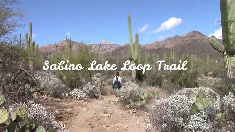
Sabino Lake Loop Trail Arizona
Sabino Lake Loop Trail in Sabino Canyon Recreation Area is a premier natural area located in Tucson, Arizona. With over 30-miles of trails, Sabino Lake Loop Trail is just one of them. Sabino Creek flows nearly year round, with the snow melt from the higher elevations including the mild winter rain and the summer monsoon's. Sabino Lake is an oasis, an opportunity to dip in the refreshing waters or try some fishing. The entirety of Sabino Canyon is an amazing luster of creation waiting for you.
26
views
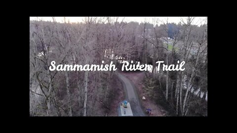
Sammamish River Trail Bothell, WA
Sammamish River Trail is 10.1 miles from Bothell to Marymoor Park in Redmond, Washington. The trail connects up to the Burke-Gilman Trail allowing connections to various locations throughout the region. The trail is part of the "Locks to Lakes Corridor". It's a very popular trail for bicyclists, joggers, skaters, walkers and others to simply enjoy nature. It's also a major bicycle commuter trail between Seattle and neighboring communities. Bothell hosts a museum, first school house and one of the first log cabins, all along along the trail for your discovery.
15
views
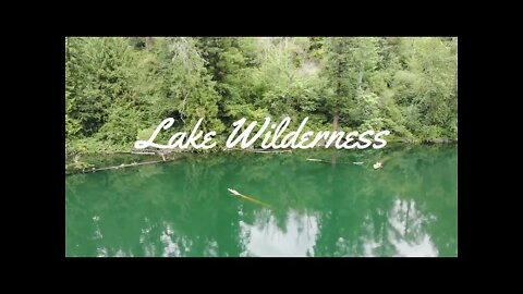
Lake Wilderness Maple Valley, Washington
Lake Wilderness is located in Maple Valley, Washington. It's a relatively small lake that offers many amenities: fishing, swimming, boating (no power boats), hiking and beautiful gardens. The surrounding area is a 450-acre watershed that is host to a number of animals and birds.
31
views
Lake Pleasant Arizona
Lake Pleasant is a reservoir serving the greater Phoenix, Arizona area. It began as a means for irrigation in the early 1900's and is now a major water supply including a playground for recreational enthusiasts. With over 10,000 acres, and a multitude of hiking trails, there's ample opportunities for everyone.
28
views
Turnbuckle Trail - Buckeye, Arizona
Turnbuckle Tail is located in the Skyline Regional Park, Buckeye, Arizona. The trail is one of many in the White Tank Mountain Range. It's a moderate loop trail, 4.2 miles, that goes to the top of a peak and brings you back to your original starting point.
34
views

Verrado Mainstreet Holiday Light Parade
The Verrado Mainstreet Holiday Light Parade is an annual event. Hundreds of decorated golf carts and side-by-sides line up for the Christmas event, parading down main street and throughout the Verrado community. The main event begins at the Verrado Town Square, all participants meet with their decorated lighted golf cart or side-by-side, and you have the opportunity to view them close up. Also take in the other festive activities at the booths and food trucks. A family fun time in Verrado (Buckeye, Arizona).
33
views
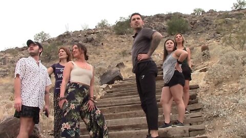
The Stairs Verrado, Arizona
The Stairs in Verrado, (Buckeye, Arizona), are 340 stairs up to a flat base area. From there you can venture off onto numerous trails. The stairs are great for a hike, a workout or a leisure stroll while taking in the views. Located at the end of Verrado Way, park in the lot and a few strides away, begin your accent up the stairs.
65
views