
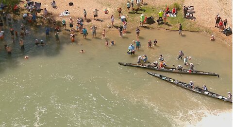
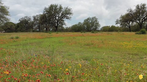
2021 Texas Water Safari Staples Dam Part 1 - A Drone View
“They don’t call the Texas Water Safari The World’s Toughest Canoe Race’ for nothing. In addition to the length, the challenges include whitewater rapids, multiple portages, and the relentless, soul-sapping Texas heat. Competitors have four days and four hours to paddle from San Marcos, in the center of the state, to the shy little town of Seadrift on the Gulf Coast. There is no prize money for the winners; just Texas-size bragging rights for the finishers.” - Larry Rice, in July 2009 Canoe & Kayak Magazine
This is Part 1 of a series of videos from Staples Dam. After the 2020 Texas Water Safari event got canceled due to Covid-19, the 2021 event was well anticipated by the regular crowd of entries, plus a good group of first timers. See https://www.texaswatersafari.org/ for information regarding this year's race.
This year, out of all the entries, 140 boats started the race in San Marcos on Saturday morning. 3 didn't make it past the first check point at Staples Dam. One determined young lady limped into Staples Dam with a broken canoe. We'll have photos and videos of her canoe in the Part 4 video, so stay tuned.
Staples Dam is private property along the shore and dam. They offer camping and other amenities to folks who want to enjoy the river on a RSVP basis only. Please call them at 512-848-8209 for more information. They are located on FM1977 in Staples Texas. Just Google "Staples Dam" to get a general idea of where this place is located.
Please feel free to hit the LIKE button if you liked this, SUBSCRIBE if you want to see more, and leave a comment with your suggestions or observations. We always read and respond to comments. We do take requests from folks that want to see different types of aerial photography / videos from areas they might not be able to access from the ground. We are a certified Part 107 commercial drone pilot. Flight authorization was obtained prior to all flights.
For more information about us, please visit Https://YellowRoseDrones.com
We flew the Autel Evo 2 Pro 6K Drone, recording in 4K / 30fps. Video Editing software was Wondershare Filmora X. Music was from Epidemic Sound. Get your free 30 day trial from Epidemic Sound by clicking on this free referral link: https://www.epidemicsound.com/referral/d2jne3/
69
views
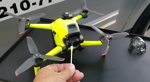
FPV Drone Gets Checked for Covid-19 at a (Not So Secret) Government Testing Center
We had the opportunity to fly thru one of the several testing centers operated by the City of San Antonio this weekend. It was after hours, with only a supervisor present, no patients or other medical staff. This video is sort of a parody, but has a serious aspect as well. In San Antonio, Texas, you can get free testing, or sign up for a vaccine appointment, by calling 311, option 8, or visiting the city's website at https://Covid19.SanAntonio.gov.
In this video, we pretended to have our drone checked out for Covid-19, but obviously you ought not be calling to set an appointment for your drone in real life. This disclaimer ought not be needed, but then again, our society had gone a bit bonkers from being locked down for the past year.
Please feel free to hit the LIKE button if you liked this, SUBSCRIBE if you want to see more, and leave a comment with your suggestions or observations. We always read and respond to comments. We do take requests from folks that want to see different types of aerial photography / videos from areas they might not be able to access from the ground. We are an insured and certified Part 107 commercial drone pilot. LAANC flight authorization was obtained prior to all flights.
For more information about us, please visit Https://YellowRoseDrones.com
We flew the DJI FPV Drone, recording in 4K / 60fps. Video Editing software was Wondershare Filmora X. Music was from Epidemic Sound. Get your free 30 day trial from Epidemic Sound by clicking on this free referral link: https://www.epidemicsound.com/referral/d2jne3/
145
views
1
comment
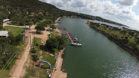
Peaceful FPV Drone Flight Over Lake Buchanan & Spider Mountain Bike Park
We were contracted to go fly before a night time trail running event at Spider Mountain Bike Park by Tejas Trails. Tejas Trails puts on a series of very popular foot races all over the state of Texas and Spider Mountain was one of their annual events. The start / finish line for this event was set up on the shores of Lake Buchanan. We used our DJI FPV drone to make a fast, and we do mean fast, flight around the area, exploring the sights and enjoying the scenery. This short 4 minute video is one of the those we'll be posting from this day's event.
For more information about Tejas Trails, visit them at https://TejasTrails.com.
For more information about Spider Mountain Bike Park, visit them at https://SpiderMountain.com
Please feel free to hit the LIKE button if you liked this, SUBSCRIBE if you want to see more, and leave a comment with your suggestions or observations. We always read and respond to comments. We do take requests from folks that want to see different types of aerial photography / videos from areas they might not be able to access from the ground. We are a certified Part 107 commercial drone pilot. Flight authorization was obtained prior to all flights.
For more information about us, please visit Https://YellowRoseDrones.com
We flew the DJI FPV Drone, recording in 4K / 60fps. Video Editing software was Wondershare Filmora X. Music was from Epidemic Sound. Get your free 30 day trial from Epidemic Sound by clicking on this free referral link: https://www.epidemicsound.com/referral/d2jne3/
51
views
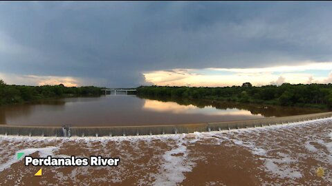
Peaceful FPV Drone Flight Over The Perdanales River After Thunderstorms
We had a request to create a video of our flight over the reflective Perdanales River without the ambient sounds or the FPV footage flying over the shore that included the sounds of the drone's propellers. This is the response to that request. We added some peaceful acoustic guitar music as the sound track instead. This is the original video without any cuts or transitions added.
On this weekend when we visited, there had been a series of thunderstorms passing thru the area and upstream of that location. The Perdanales River was running a bit high and very muddy. There were multiple fishermen along the shoreline and they were catching mostly Carp fish.
We made multiple flights with a couple of different drones, but this flight later in the evening turned out perfect with the clearing blue skies reflecting off the calm water surface. Our earlier flights did not have this reflection because the water surface was too choppy from the thunderstorm generated winds. We hope you enjoy this video as much as we did catching the view just at the right time and angle...
Please feel free to hit the LIKE button if you liked this, SUBSCRIBE if you want to see more, and leave a comment with your suggestions or observations. We always read and respond to comments. We do take requests from folks that want to see different types of aerial photography / videos from areas they might not be able to access from the ground. We are a certified Part 107 commercial drone pilot. Flight authorization was obtained prior to all flights.
For more information about us, please visit Https://YellowRoseDrones.com
We flew the DJI FPV Drone, recording in 4K / 60fps. Video Editing software was Wondershare Filmora X. Music was from Epidemic Sound. Get your free 30 day trial from Epidemic Sound by clicking on this free referral link: https://www.epidemicsound.com/referral/d2jne3/
18
views
Peaceful Drone Flight thru the Wildflowers at Perdanales River Nature Park
Took these videos with a DJI Mavic 2 Pro drone at the Perdanales River Nature Park, up on Hwy 281, in Johnson City. $2 admission for seniors, $5 for adults, all on the honor system. No manned gate, just a drop box. The flowers were so beautiful that we just had to fly around for awhile, just a few feet off the ground, to see the flowers.
While we were there, we also went down to the Perdanales River shore at the back of the park. Saw a photographer posing a couple on a blanket with wildflowers in the background, along with the river. Not very busy at all and this was on a Saturday afternoon, albeit with threatening thunderstorms and high winds in the area that day.
Please feel free to hit the LIKE button if you liked this, SUBSCRIBE if you want to see more, and leave a comment with your suggestions or observations. We always read and respond to comments. We do take requests from folks that want to see different types of aerial photography / videos from areas they might not be able to access from the ground. We are a certified Part 107 commercial drone pilot. Flight authorization was obtained prior to all flights.
For more information about us, please visit Https://YellowRoseDrones.com
We flew the DJI Mavic 2 Pro Drone, recording in 4K / 30fps. Video Editing software was Wondershare Filmora X. Ambient noise track recorded live while we were there. Music track is from Epidemic Sound. Get your free 30 day trial from Epidemic Sound by clicking on this free referral link: https://www.epidemicsound.com/referral/d2jne3/
11
views

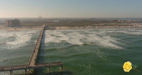
Chasing Seagulls on the Beach at Port Aransas on the Texas Gulf Coast
The Coastal Bend Flying Circus and the Surfside Flyers Kite Club teamed up to put on a Kite Festival over the weekend of April 24-25th 2021, on the beach in Port Aransas Texas. The festival started around 10am Saturday, paused for a few hours around midnight, then resumed Sunday morning until mid afternoon.
The winds were not very kind to kites during Saturday afternoon, but picked up again just in time for the night show with these illuminated kites.
While the winds weren't friendly to the larger kites, we took to the beach with our Osmo Action Camera on a selfie stick to see what the seagulls were up do. Lots of action by the seagulls, but fortunately none of them crapped on my head... We did fly the drone over a flock of them while they were on the sand, but it didn't really seem to bother them all that much. Even when the drone was flying near them in the air, they largely ignored the drone.
We had been invited to come fly our drones to record the event and this is one of those resulting videos. We frequently like come visit the coast whenever Surfside Flyers Kite Club hold an event, but this was a first time for us to spend time with the Coastal Bend Flying Circus.
Please feel free to hit the RUMBLE button if you liked this, SUBSCRIBE if you want to see more, and leave a comment with your suggestions or observations. We always read and respond to comments. We do take requests from folks that want to see different types of aerial photography / videos from areas they might not be able to access from the ground. We are a certified Part 107 commercial drone pilot. Flight authorization was obtained prior to all flights.
For more information about us, please visit Https://YellowRoseDrones.com
We flew the Autel Evo 2 Pro drone, recording in 4K / 30fps. The DJI Osmo Action Camera was recording in 4K / 30fps as well. Video Editing software was Wondershare Filmora X. The audio track was recorded live from a digital recorder set up on a tripod out on the beach.
50
views
1
comment
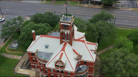
Drone view of the Beautiful Historic 128yo Lee County Courthouse in Downtown Giddings Texas
We were in Giddings, Texas, over the weekend, helping out with the Big Texas MS-150 Bicycle ride on the La Grange to College Station route. We spent the night in Giddings and spotted this beautiful brick courthouse. This is the Lee County Courthouse.
Naturally, we had to power up a drone and check it out. Being on a Saturday, the courthouse was closed and there weren't any pedestrians for us to worry about flying above while we did this.
The original courthouse was built in 1878, burned down in 1897, and rebuilt in 1897 using convict labor. See video for more details.
[SOURCE: http://texascourthouses.com/project/lee-county-courthouse/]
Please feel free to hit the RUMBLE button if you liked this, SUBSCRIBE if you want to see more, and leave a comment with your suggestions or observations. We always read and respond to comments. We do take requests from folks that want to see different types of aerial photography / videos from areas they might not be able to access from the ground. We are a certified Part 107 commercial drone pilot. Flight authorization was obtained prior to all flights.
For more information about us, please visit Https://YellowRoseDrones.com
We flew the DJI Mavic 2 Pro drone, recording in 4K / 30fps. Video Editing software was Wondershare Filmora X. Music was from Epidemic Sound. Get your free 30 day trial from Epidemic Sound by clicking on this free referral link: https://www.epidemicsound.com/referral/d2jne3/
50
views
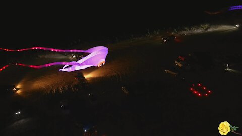
Spectacular drone view of nighttime beach kite flying
The Coastal Bend Flying Circus and the Surfside Flyers Kite Club teamed up to put on a Kite Festival over the weekend of April 24-25th 2021, on the beach in Port Aransas Texas. The festival started around 10am Saturday, paused for a few hours around midnight, then resumed Sunday morning until mid afternoon.
The winds were not very kind to kites during Saturday afternoon, but picked up again just in time for the night show with these illuminated kites. We were invited to come fly our drones to record the event and this is one of those resulting videos. We frequently like come visit the coast whenever Surfside Flyers Kite Club hold an event, but this was a first time for us to spend time with the Coastal Bend Flying Circus.
We flew the Autel Evo 2 Pro drone, recording in 4K / 30fps. Video Editing software was Wondershare Filmora X. The audio track was recorded live from a digital recorder set up on a tripod out on the beach.
3.14K
views
10
comments
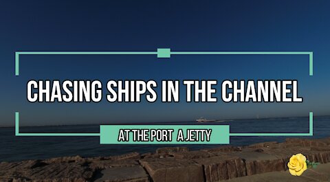
Drone Chasing Ships in the Channel near the Port A Jetty in Port Aransas Texas
The Coastal Bend Flying Circus and the Surfside Flyers Kite Club teamed up to put on a Kite Festival over the weekend of April 24-25th 2021, on the beach in Port Aransas Texas. The winds were not very kind to kites during Saturday afternoon, but picked up again just in time for the night show with these illuminated kites.
We were invited to come fly our drones to record the event and this is one of those resulting videos. We frequently like come visit the coast whenever Surfside Flyers Kite Club hold an event, but this was a first time for us to spend time with the Coastal Bend Flying Circus.
The pass at Port Aransas is a natural channel that has existed for many hundreds of years. The current jetties were built between 1906 and 1911. Access to the jetties is free. Both the North and South Jetty are very popular with fishermen and can be good for a large variety of species throughout the year.
The South Jetty is part of the I.B. MaGee Beach Park, operated by Nueces County Parks Department. Free admission, but you will need the $12 annual Beach Parking Permit in order to do more than just drive by and look. You can buy the permit at any local gas station or most tourist shops in the Corpus Christi and Port Aransas areas.
[Source: http://www.stxmaps.com/go/port-aransas-south-jetty.html]
Please feel free to hit the LIKE button if you liked this, SUBSCRIBE if you want to see more, and leave a comment with your suggestions or observations. We always read and respond to comments. We do take requests from folks that want to see different types of aerial photography / videos from areas they might not be able to access from the ground. We are a certified Part 107 commercial drone pilot. Flight authorization was obtained prior to all flights.
For more information about us, please visit Https://YellowRoseDrones.com
We flew the Autel Evo 2 Pro drone, recording in 4K / 30fps. Video Editing software was Wondershare Filmora X. The audio track was recorded live from a digital recorder set up on a tripod out on the beach.
66
views
A Drone View at IB Magee Beach of the Horace Caldwell Fishing Pier in Port Aransas Texas
The Coastal Bend Flying Circus and the Surfside Flyers Kite Club teamed up to put on a Kite Festival over the weekend of April 24-25th 2021, on the beach in Port Aransas Texas. The winds were not very kind to kites during Saturday afternoon, but picked up again just in time for the night show with these illuminated kites.
We were invited to come fly our drones to record the event and this is one of those resulting videos. We frequently like come visit the coast whenever Surfside Flyers Kite Club hold an event, but this was a first time for us to spend time with the Coastal Bend Flying Circus.
The pass at Port Aransas is a natural channel that has existed for many hundreds of years. The current jetties were built between 1906 and 1911. Access to the jetties is free. Both the North and South Jetty are very popular with fishermen and can be good for a large variety of species throughout the year.
The South Jetty is part of the I.B. MaGee Beach Park, operated by Nueces County Parks Department. Free admission, but you will need the $12 annual Beach Parking Permit in order to do more than just drive by and look. You can buy the permit at any local gas station or most tourist shops in the Corpus Christi and Port Aransas areas.
[Source: http://www.stxmaps.com/go/port-aransas-south-jetty.html]
Please feel free to hit the RUMBLE button if you liked this, SUBSCRIBE if you want to see more, and leave a comment with your suggestions or observations. We always read and respond to comments. We do take requests from folks that want to see different types of aerial photography / videos from areas they might not be able to access from the ground. We are a certified Part 107 commercial drone pilot. Flight authorization was obtained prior to all flights.
For more information about us, please visit Https://YellowRoseDrones.com
We flew the Autel Evo 2 Pro drone, recording in 4K / 30fps. Video Editing software was Wondershare Filmora X. The audio track was recorded live from a digital recorder set up on a tripod out on the beach.
448
views
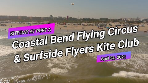
A Drone View of Kite Day at Port Aransas with Coastal Bend Flying Circus & Surfside Flyers Kite Club
The Coastal Bend Flying Circus and the Surfside Flyers Kite Club teamed up to put on a Kite Festival over the weekend of April 24-25th 2021, on the beach in Port Aransas Texas. The festival started around 10am Saturday, paused for a few hours around midnight, then resumed Sunday morning until mid afternoon.
The winds were not very kind to kites during Saturday afternoon, but picked up again just in time for the night show with these illuminated kites. We were invited to come fly our drones to record the event and this is one of those resulting videos. We frequently like come visit the coast whenever Surfside Flyers Kite Club hold an event, but this was a first time for us to spend time with the Coastal Bend Flying Circus.
Please feel free to hit the RUMBLE button if you liked this, SUBSCRIBE if you want to see more, and leave a comment with your suggestions or observations. We always read and respond to comments. We do take requests from folks that want to see different types of aerial photography / videos from areas they might not be able to access from the ground. We are a certified Part 107 commercial drone pilot. Flight authorization was obtained prior to all flights.
For more information about us, please visit Https://YellowRoseDrones.com
We flew the Autel Evo 2 Pro drone, recording in 4K / 30fps. Video Editing software was Wondershare Filmora X. The audio track was recorded live from a digital recorder set up on a tripod out on the beach.
72
views
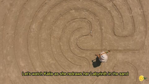
A Drone View of a Lady Drawing a Sand Labyrinth on the Beach at Port Aransas
The Coastal Bend Flying Circus and the Surfside Flyers Kite Club teamed up to put on a Kite Festival over the weekend of April 24-25th 2021, on the beach in Port Aransas Texas. The festival started around 10am Saturday, paused for a few hours around midnight, then resumed Sunday morning until mid afternoon.
One of the Surfside Flyers Kite Club members, Kathy, loves the beach, both to fly her kites and to draw labyrinths in the sand. This is Kathy's video...
(Update: I misspelled her name in the video. For some reason I initially thought her name was Katie instead of Kathy. My apologies.)
Please feel free to hit the RUMBLE button if you liked this, SUBSCRIBE if you want to see more, and leave a comment with your suggestions or observations. We always read and respond to comments. We do take requests from folks that want to see different types of aerial photography / videos from areas they might not be able to access from the ground.
We are a certified Part 107 commercial drone pilot. Flight authorization was obtained prior to all flights. We do have a valid 107.29 Daylight Waiver which allows us to fly after dark with proper anti-collision strobes installed.
For more information about us, please visit Https://YellowRoseDrones.com
We flew the Autel Evo 2 Pro drone, recording in 4K / 30fps. Video Editing software was Wondershare Filmora X. The audio track was recorded live from a digital recorder set up on a tripod out on the beach.
37
views

Drone captures stunning visuals of carnival in Texas
On the way home from New Braunfels, we passed by Retama Park in Selma, Texas. This well lit carnival was very obvious from the street, so we decided to come back the next night and video it with one of our drones. We first obtained written authorization to fly up to 400ft AGL (Above Ground Level) after 2100 hours in an area normally restricted to 50ft AGL even in daytime.
3.91K
views
34
comments

West Texas Scenery - Cacti, Water and Oil Wells
We made a trip from San Antonio, to the Carrizo Springs, Texas, area the other week. We spotted lots of cacti with yellow blooming flowers, windmills and oil rigs. We stopped at a roadside park near the Nueces River as well, just to check it out. This video was made from some of the scenery that we found along Highway 85 between Big Wells and Carrizo Springs, out in West Texas. By the way, the opening scene features the yellow blooming Opuntia Cactus, which is the largest genus in the cactus family. You will recognize most by their classic “prickly pear” appearance.
[Source: Read more at Gardening Know How: Opuntia Cactus Varieties: What Are Different Types Of Opuntia Cactus https://www.gardeningknowhow.com/ornamental/cacti-succulents/prickly-pear/opuntia-cactus-varieties.htm ]
Please feel free to hit the RUMBLE button if you liked this, SUBSCRIBE if you want to see more, and leave a comment with your suggestions or observations. We always read and respond to comments. We do take requests from folks that want to see different types of aerial photography / videos from areas they might not be able to access from the ground. We are a certified Part 107 commercial drone pilot. Flight plans were filed prior to all flights.
For more information about us, please visit Https://YellowRoseDrones.com
We flew the DJI Mavic 2 Pro drone, recording in 4K / 30fps. Video Editing software was Wondershare Filmora X. Music was from Epidemic Sound. Get your free 30 day trial from Epidemic Sound by clicking on this free referral link: https://www.epidemicsound.com/referral/d2jne3/
39
views
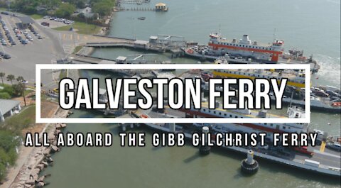
Galveston Ferry All Aboard the Gibb Gilchrist Ferry
The Galveston-Bolivar ferry is the link between Galveston and Bolivar Peninsula on Hwy 87. A service provided FREE to all travelers 24 hours a day by TX-Dot since 1934. Each trip covers about 2.7 miles and takes about 18 minutes to cross, excluding the wait time for loading and unloading cars.
Each ferry can carry approximately 70 vehicles, 500 passengers and 6 crew members, only 8-eighteen wheelers may board at once and carry 80,000 lbs. each.
You can drive your vehicle-on or walk-on depending on your plans. One ferry operates 24 hours a day while a second is placed in service at 6:30am and a 3rd in the afternoon. Up to 6 ferries may be in operation during peak seasons, holidays, events and as traffic calls for more frequent service.
[Source: https://www.bolivarpeninsulatexas.com/About/Galveston-Bolivar-Ferry]
This is the third of several videos on this particular topic and location.
Please feel free to hit the LIKE button if you liked this, SUBSCRIBE if you want to see more, and leave a comment with your suggestions or observations. We always read and respond to comments. We do take requests from folks that want to see different types of aerial photography / videos from areas they might not be able to access from the ground. We are a certified Part 107 commercial drone pilot. Flight plans were filed prior to all flights.
For more information about us, please visit Https://YellowRoseDrones.com
We flew the Autel Evo 2 Pro drone, recording in 4K / 30fps. Video Editing software was Wondershare Filmora X. Audio track was recorded live from the shore while the drone was flying.
52
views
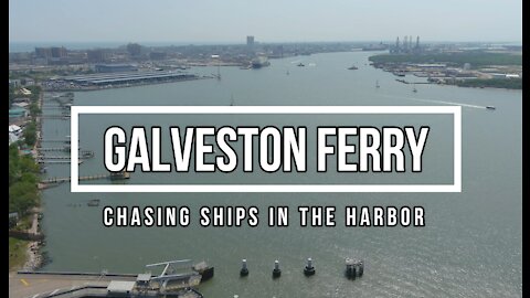
Galveston Ferry: Chasing Ships In The Harbor - A Drone View
This video was made from our drone flying over the Houston Channel, between Galveston Island and Pelican Island (where the Seawolf Park is located). We selected clips of the various ships, boats and ferries to share with you, but did not want to make it so long that you would get bored watching. We hope you enjoy watching it as much as we did flying overhead.
This is just the second of several videos on this particular topic and location. Please feel free to hit the RUMBLE button if you liked this, SUBSCRIBE if you want to see more, and leave a comment with your suggestions or observations. We always read and respond to comments. We do take requests from folks that want to see different types of aerial photography / videos from areas they might not be able to access from the ground. We are a certified Part 107 commercial drone pilot. Flight plans were filed prior to all flights.
For more information about us, please visit Https://YellowRoseDrones.com
We flew the Autel Evo 2 Pro drone, recording in 4K / 30fps. Video Editing software was Wondershare Filmora X. Audio track was recorded live from the shore while the drone was flying.
262
views
1
comment

Drone footage of historic lighthouse in Port Galveston, Texas
The Bolivar Lighthouse was built by the federal government in 1852 and was later dismantled by Confederate soldiers during the Civil War. It was rebuilt in 1872 and was the beacon that guided thousands of mariners into port until 1933.
The 52,000 candle-power beacon guided ships through the channel into the Port of Galveston. The lighthouse withstood three of the worst storms hitting the peninsula; the 1900 and 1915 storms and Hurricane Ike in 2008.
The Bolivar Lighthouse was officially retired on May 29, 1933, after 61 years of service. It is being rebuilt by private sources and is not currently open to the public (as of April 2021).
1.89K
views
1
comment
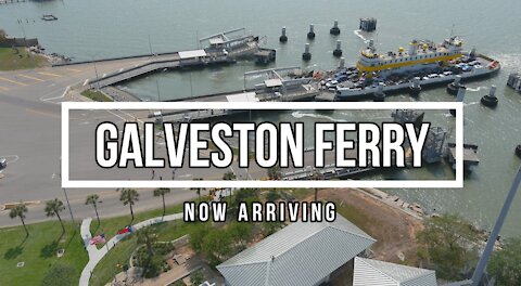
Galveston Bolivar Point Ferry Now Arriving - A Drone View Series Video
The Galveston-Bolivar ferry is the link between Galveston and Bolivar Peninsula on Hwy 87. A service provided FREE to all travelers 24 hours a day by TX-Dot since 1934.
Each trip covers about 2.7 miles and takes about 18 minutes.
Each ferry can carry approximately 70 vehicles, 500 passengers and 6 crew members, only 8-eighteen wheelers may board at once and carry 80,000 lbs. each.
You can drive your vehicle-on or walk-on depending on your plans. One ferry operates 24 hours a day while a second is placed in service at 6:30am and a 3rd in the afternoon. Up to 6 ferries may be in operation during peak seasons, holidays, events and as traffic calls for more frequent service.
[Source: https://www.bolivarpeninsulatexas.com/About/Galveston-Bolivar-Ferry]
This is just the first of several videos on this particular topic and location. Please feel free to hit the RUMBLE button if you liked this, SUBSCRIBE if you want to see more, and leave a comment with your suggestions or observations. We always read and respond to comments. We do take requests from folks that want to see different types of aerial photography / videos from areas they might not be able to access from the ground. We are a certified Part 107 commercial drone pilot. Flight plans were filed prior to all flights.
For more information about us, please visit Https://YellowRoseDrones.com
We flew the Autel Evo 2 Pro drone, recording in 4K / 30fps. Video Editing software was Wondershare Filmora X. Music was from Epidemic Sound. Get your free 30 day trial from Epidemic Sound by clicking on this free referral link: https://www.epidemicsound.com/referral/d2jne3/
28
views
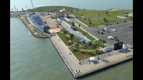
Visiting Seawolf Park on Pelican Island In Galveston Texas With A Drone April 2021
Seawolf Park is located on Galveston’s Pelican Island on a former immigration station site. Open year-round dawn to dusk. Admission is $6 per car. Fishing Bands and admission to the fenced in area around the exhibit ships and museum are extra. Fishing is 24 hrs 7 days a week.
The park offers one of the island’s most popular fishing piers, picnic sites and a playground. The park is also home to tourist attractions, including the WWII submarine the USS Cavalla and one of only three destroyer escorts in the world, the USS Stewart.
The remains of the WWI tanker S.S. Selma, the largest concrete ship constructed, can be seen northwest of the park's fishing pier.
[Source: https://tinyurl.com/SeawolfPark]
Please feel free to hit the RUMBLE button if you liked this, SUBSCRIBE if you want to see more, and leave a comment with your suggestions or observations. We always read and respond to comments. We do take requests from folks that want to see different types of aerial photography / videos from areas they might not be able to access from the ground. We are a certified Part 107 commercial drone pilot. Flight plans were filed prior to all flights.
For more information about us, please visit Https://YellowRoseDrones.com
We flew the Autel Evo 2 Pro drone, recording in 4K / 30fps. Video Editing software was Wondershare Filmora X. Music was from Epidemic Sound. Get your free 30 day trial from Epidemic Sound by clicking on this free referral link: https://www.epidemicsound.com/referral/d2jne3/
24
views

Sunset Over Medina Lake - From A Drone's Perspective
We were in the mood to do some drone flying around Sunset and headed out west of San Antonio to a recreational reservoir called Medina Lake. We stopped at the Red Cove Marina to launch our Autel Evo 2 Pro 6K drone and do some test flights.
This video is comprised of just some of the footage we took that evening.When we saw that little sailboat approaching the southern end of the lake, near the Dam, we just had to fly out to greet it.
We will produce a short series of videos using footage from this evening's flying and this was just the second one to be edited and compiled.
Please feel free to hit the LIKE button if you liked this, SUBSCRIBE if you want to see more, and leave a comment with your suggestions or observations. We always read and respond to comments. We do take requests from folks that want to see different types of aerial photography / videos from areas they might not be able to access from the ground. We are a certified Part 107 commercial drone pilot. Flight plans were filed prior to all flights. For more information about us, please visit https://YellowRoseDrones.com.
We flew the Autel Evo 2 Pro drone, recording in 4K / 30fps. Video Editing software was Wondershare Filmora X. Music was from Epidemic Sound.
52
views

Drone Video of a Sailboat Sailing at Sunset on Medina Lake in Texas
We were in the mood to do some drone flying around Sunset and headed out west of San Antonio to a recreational reservoir called Medina Lake. We stopped at the Red Cove Marina to launch our Autel Evo 2 Pro 6K drone and do some test flights. This video is comprised of just some of the footage we took that evening.
When we saw that little sailboat approaching the southern end of the lake, near the Dam, we just had to fly out to greet it. The couple on the boat never showed any sign that they had spotted our drone, but we were trying to keep our distance and height, using the zoom features of the camera to not interfere with their peaceful sailing experience. The orbiting of the sailboat was done manually, so it's a bit more jerky than the automatic mode would have produced, but where's the challenge in that?
We will produce a short series of videos using footage from this evening's flying and this was just the first one to be edited and compiled.
Please feel free to hit the RUMBLE button if you liked this, SUBSCRIBE if you want to see more, and leave a comment with your suggestions or observations. We always read and respond to comments. We do take requests from folks that want to see different types of aerial photography / videos from areas they might not be able to access from the ground. We are a certified Part 107 commercial drone pilot. Flight plans were filed prior to all flights.
For more information about us, please visit Https://YellowRoseDrones.com
We flew the Autel Evo 2 Pro drone, recording in 4K / 30fps. Video Editing software was Wondershare Filmora X. Music was from Epidemic Sound.
158
views

Autel Evo 2 Pro Drone Flight Around The Tower of The Americas in Downtown San Antonio Texas
The Tower of the Americas is a 750-foot (229-meter) observation tower-restaurant located in the Hemisfair district on the southeastern portion of Downtown San Antonio, Texas, United States. It was the tallest observation tower in the United States from 1968 until 1996, when the Las Vegas Stratosphere Tower was completed. The Tower is the tallest building in San Antonio, and it is the 30th-tallest building in Texas.
The Tower is located in the middle of the former HemisFair '68 site and has an observation deck that is accessible by elevator for a fee. There is also a lounge and revolving restaurant at the top of the Tower that provides panoramic views of the city.
Source: https://en.wikipedia.org/wiki/Tower_of_the_Americas
We made good use of that 6K camera on the Autel Evo 2 Pro drone and it's ability to zoom in from a distance, to get some really close up shots where you can see the tourists on the observation deck inside. We did not see anyone inside that observation deck pointing in the direction of the drone, so we must have been successful in staying anonymous. If you were up in the Tower between 6pm and 7pm CDT on March 15th, let us know if you spot yourself in this video.
Please feel free to hit the LIKE button if you liked this, SUBSCRIBE if you want to see more, and leave a comment with your suggestions or observations. We always read and respond to comments. We do take requests from folks that want to see different types of aerial photography / videos from areas they might not be able to access from the ground.
We are a certified Part 107 commercial drone pilot. Flight plans were filed prior to all flights. While Recreational Pilots are restricted by the FAA regulations to not flying above 400ft, Part 107 pilots can fly up to 400ft above a structure, if within a certain radius distance. This (flight) had been on our bucket list for several years, but we just now made the time to get er done!
We flew the Autel Evo 2 Pro drone, recording in 4K / 30fps. Video Editing software was Wondershare Filmora X. Music was from Epidemic Sound.
114
views
1
comment
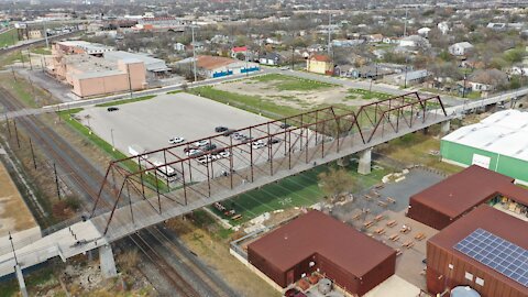
Drone view of the 1881-1910 Hays Street Bridge in the Dignowity Hill Historic District
The Hays Street Bridge, constructed as two separate railroad bridges in the late nineteenth century, is the oldest metal truss bridge in San Antonio. Since 1910, when it was moved to its current location, it has served as a viaduct connecting the east side of the city to downtown.
We wish to thanks the folks at Inside410.com for keeping this bit of history alive in our community.
By the early twentieth century, the Galveston, Harrisburg and San Antonio Railway Company planned to expand their tracks across east-west streets between downtown and the city's east side. The city agreed to the expansion provided the railroad erected a viaduct for pedestrians and vehicular traffic to cross the tracks.
In 1910, the railroad moved two wrought iron spans from elsewhere on its lines and widened them from 25 feet to construct a bridge over the tracks at Hays Street. The longer of the two spans, dating to 1881, came from a railroad crossing at the Nueces River west of Uvalde, Texas.
In 1982, structural concerns forced the closing of the bridge. It fell into a state of disrepair and faced demolition until a group of supporters, including engineers, preservationists, East side residents and bike enthusiasts, petitioned the city to save the bridge. As a result of their efforts, the bridge received $2.89 million in federal TEA-21 funding for restoration in 2001. It was also designated a Texas Historic Civil Engineering Landmark and a City of San Antonio Local Landmark. The City of San Antonio assumed ownership of the bridge from Union Pacific in 2007 and began restoration work in 2009, completing it in 2010.
Renovated for pedestrian and bicycle use, the historic bridge serves as a gateway linking downtown to the Dignowity Hill Historic District and to the Salado Creek Hike and Bike Trail.
Info Source: https://www.inside410.com/post/2019/01/24/history-engaged-dignowity-hill-and-the-hays-street-bridge
______________________________________
Please feel free to hit the RUMBLE button if you liked this, SUBSCRIBE if you want to see more, and leave a comment with your suggestions or observations. We always read and respond to comments. We do take requests from folks that want to see different types of aerial photography / videos from areas they might not be able to access from the ground. We are a certified Part 107 commercial drone pilot. Flight plans were filed prior to all flights.
We flew the DJI Mavic 2 Pro drone, recording in 4K / 30fps. Video Editing software was Wondershare Filmora X. Music was from Epidemic Sound. Get your free 30 day trial from Epidemic Sound by clicking on this free referral link: https://www.epidemicsound.com/referral/d2jne3/
86
views
2
comments
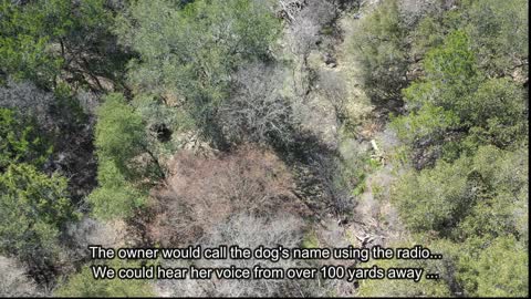
Drones Search for Otto the Missing 3-Legged Dog
Mike Moody, from Drone Force, reached out to the local drone club on Facebook to ask for volunteer drone pilots to help continue search for a missing 3-legged dog that had run off from a veterinary clinic in the Stone Oak area on the north side of San Antonio. We answered the call for help and coordinated with Mike to be a part of the search on Day 4, Sunday March 7th. Mike had already been searching for some very long days, but thought that our wireless drone speaker system might perhaps make a difference.
Each pilot filed flight plans with the LAANC System before launching their drones. Fortunately, this area allowed drone flights of up to 100ft AGL (Above Ground Level), or higher, depending upon which direction we flew. This wasn't a situation where flying higher would give us a better view.
We let the owner wear a pair of DJI Goggles linked to our DJI Mavic 2 Pro drone. We strapped the wireless speaker on top of the drone and then handed the radio transmitter to Otto's owner while we flew around various areas at around 50-60ft above ground level, just above the trees.
With the recent snowstorm 3 weeks ago, many of the trees had lost their leaves, making it slightly easier to see the ground level.
Drone Force did a very professional job of coordinating flight areas and altitudes to prevent potential collisions in the air between the various unmanned aircraft.
Unfortunately, as of late Sunday afternoon when the searchers took a well deserved break, Otto the dog had not yet been found. The search was to continue before sunset and will likely continue for several more days until Otto has been located. Locals had seen the dog after reading the flyer.
Obviously there probably aren't many 3-legged dogs with surgical bandages roaming the area. Fresh reports had been arriving every day, leaving the searchers with hope that Otto was still in the area.
The search continues...
Please feel free to hit the RUMBLE button if you liked this, SUBSCRIBE if you want to see more, and leave a comment with your suggestions or observations. We always read and respond to comments. We do take requests from folks that want to see different types of aerial photography / videos from areas they might not be able to access from the ground. We are a certified Part 107 commercial drone pilot.
We flew the DJI Mavic 2 Pro drone, recording in 4K / 30fps. Video Editing software was Wondershare Filmora X. Music was from Epidemic Sound.
182
views
3
comments
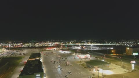
New Braunfels Night Flight with the Autel Evo 2 Pro Drone
This was a spur of the moment flight, while we was waiting for a client (my normal job, not a drone job) to finish up the items that I was there to pick up. We had the the Autel Evo 2 Pro 6K drone with us, so we put it up in the air just to see how well the camera worked during low light situations. I thought it did pretty well, but there were areas like the Buccee's parking lot where the light levels were extremely bright, compared with some of the surrounding areas, so the video was over exposed slightly. We did not attempt to adjust the camera settings, as we might have done, had this been for a commercial flight. This is raw footage, unedited, without any color correction or post production work.
This flight was just to have fun and kill some time looking around from 200ft AGL (Above Ground Level) while waiting. The drone did have the required anti-collision strobe on top and it's built-in orientation lights were very visible. We shared the view with a couple of workers from the Domino's Pizza store who were also out behind the shopping center where we had launched from and they were very impressed.
We could see the control tower from the New Braunfels Regional Airport off in the distance to the east (marked during the video) and the detail available in the nearby HEB shopping center was amazingly clear.
Please feel free to hit the LIKE button if you liked this, SUBSCRIBE if you want to see more, and leave a comment with your suggestions or observations. We always read and respond to comments. We do take requests from folks that want to see different types of aerial photography / videos from areas they might not be able to access from the ground. We are a certified Part 107 commercial drone pilot.
We flew the Autel Evo 2 Pro drone, recording in 4K / 30fps. Video Editing software was Wondershare Filmora X. Music was from Epidemic Sound.
225
views
10
comments