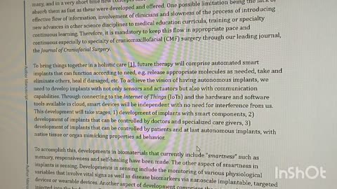
1 year agoUnmanned aerial vehicles to handle medical emergency data transmission surveillance system by using wireless body area network COV-WBANnonvaxer420
4 years agoA Lozenge boosting immunity in a COVID world which also offsets the global recessionHealth Biz and Politics
3 years agoDr. Srinivas Rao - CSO, atai Life Sciences - Transforming The Treatment Of Mental Health DisordersProgressPotentialAndPossibilities
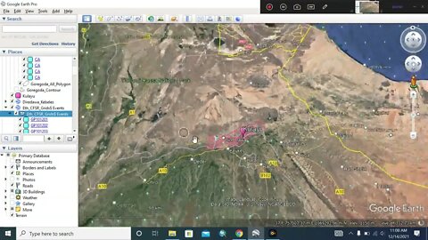
2 years agoHow to Georeference, mask with Dem & Export a watershed from Globalmapper to ArcGisYeguzoMastawosha
2 years ago#arcgis #usgs #watershed #googleearth #dem #CFSR_Grids | How to Download DEM & Delineate a WatershedYeguzo Mastawosha
2 years agoBeautiful House | Design Trends 2023 - NEW Living Room design 2023Beautiful Home Design ideasVerified
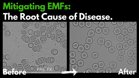
10 months agoLive Blood Analysis: Eliminating EMF Toxicity : The Root Cause of Chronic DiseaseEssential Energy For EMF Protection+
10 months agoMitigating EMF Toxicity at the Cellular Level via Resonant Harmonics of PhotonsEssential Energy For EMF Protection+
11 months agoMitigating EMF Toxicity at the Cellular Level via Resonant Harmonics of PhotonsEssential Energy For EMF Protection+