
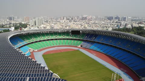
Kaohsiung National Stadium 國家體育場 🇹🇼 (2018-11) {aerial}
Aerial views of National Stadium 國家體育場, Zuoying District, Kaohsiung City, Taiwan, Republic of China [22°42'10.2"N 120°17'40.4"E]
#nationalstadium #worldgamesstadium #architecture #stadium #sports #nature #scenery #landscape #park #urban #recreation #city #ToyoIto #zuoyingdistrict #kaohsiung #高雄 #taiwan #台灣 #republicofchina #asia #aerial #uav #drone #dronevideo
Music:
Navajo Night by Audionautix is licensed under a Creative Commons Attribution license (https://creativecommons.org/licenses/by/4.0/)
Artist: http://audionautix.com/
1
view
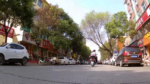
Driving in Fangcheng County 🇨🇳 (2019-01)
Street views in Fangcheng County (urban, rural, paved, dirt) without narration.
#actioncam #traffic #car #road #city #countryside #fangcheng #henan #peoplesrepublicofchina #asia
1
view

National Kaohsiung Center for the Arts - Weiwuying - 衛武營國家藝術文化中心 🇹🇼 (2018-11) {aerial}
Aerial views of National Kaohsiung Center for the Arts - Weiwuying - 衛武營國家藝術文化中心, Fengshan District, Kaohsiung City, Taiwan, Republic of China [22°37'24.6"N 120°20'31.9"E]
#nationalkaohsiungcenterforthearts #weiwuying #architecture #opera #play #art #nature #scenery #landscape #park #culture #urban #recreation #city #mecanoo #mecanooarchitects #fengshandistrict #kaohsiung #高雄 #taiwan #台灣 #republicofchina #asia #aerial #uav #drone #dronevideo
https://www.npac-weiwuying.org/?lang=en
https://www.mecanoo.nl/
Music:
Drone in D by Kevin MacLeod is licensed under a Creative Commons Attribution license (https://creativecommons.org/licenses/by/4.0/)
Source: http://incompetech.com/music/royalty-free/index.html?isrc=USUAN1200044
Artist: http://incompetech.com/
2
views
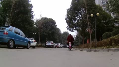
The roads of Fangcheng 🇨🇳 (2019-01)
Views without narration: Ninebot Mini ride, road traffic with many kinds of vehicles, low angle of view.
#actioncam #scenery #streetlife #traffic #street #fangcheng #henan #peoplesrepublicofchina #china #asia
11
views
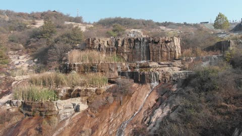
72-Lakes Resort 方城七十二谭 🇨🇳 (2018-11) {aerial}
Aerial views of 72-Lakes Resort 方城七十二谭, lakes, ponds, mountains, and valleys, Fangcheng County, Henan, People's Republic of China. [33°24'20.5"N 112°57'49.6"E]
#mountain #lake #landscape #scenery #nature #fangcheng #henan #peoplesrepublicofchina #china #hiking #trees #lake #valley #park #recreation #fangchengcounty #asia #aerial #uav #drone #dronevideo
Music:
Happy Bee Surf by Kevin MacLeod is licensed under a Creative Commons Attribution license (https://creativecommons.org/licenses/by/4.0/)
Source: http://incompetech.com/music/royalty-free/index.html?isrc=USUAN1300015
Artist: http://incompetech.com/
Virtues Inherited, Vices Passed On by Chris Zabriskie is licensed under a Creative Commons Attribution license (https://creativecommons.org/licenses/by/4.0/)
Source: http://chriszabriskie.com/reappear/
Artist: http://chriszabriskie.com/
Direct to Video by Chris Zabriskie is licensed under a Creative Commons Attribution license (https://creativecommons.org/licenses/by/4.0/)
Source: http://chriszabriskie.com/dtv/
Artist: http://chriszabriskie.com/
Take Off and Shoot a Zero by Chris Zabriskie is licensed under a Creative Commons Attribution license (https://creativecommons.org/licenses/by/4.0/)
Source: http://chriszabriskie.com/stuntisland/
Artist: http://chriszabriskie.com/
The Life and Death of a Certain K. Zabriskie, Patriarch by Chris Zabriskie is licensed under a Creative Commons Attribution license (https://creativecommons.org/licenses/by/4.0/)
Source: http://chriszabriskie.com/vendaface/
Artist: http://chriszabriskie.com/
2
views
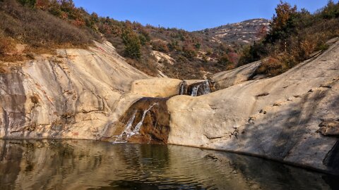
Scaling Seven Peaks Mountain by Drone 七峰山生态旅游区 🇨🇳 (2018-10) {aerial}
Aerial views of Seven Peaks Mountain 七峰山生态旅游区 and surrounding area, Fangcheng County, Henan, People's Republic of China. [33°23'45.0"N 112°58'17.4"E]
#mountain #landscape #scenery #nature #fangcheng #henan #peoplesrepublicofchina #china #hiking #trees #peak #valley #park #recreation #fangchengcounty #asia #aerial #uav #drone #dronevideo
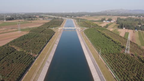
South-North Water Transfer Project, Fangcheng County 🇨🇳 (2018-09) {aerial}
Aerial views of civil structures of South-North Water Transfer Project (南水北调工程) central route at Fangcheng County, Henan, People's Republic of China.
The South–North Water Transfer Project is a infrastructure mega-project in the People's Republic of China. It aims to channel fresh water from the Yangtze River in southern China to the more arid and industrialized north through three canal systems. The central, or middle, route runs from Danjiangkou Reservoir on the Han river, a tributary of the Yangtze River, to Beijing. The canal was constructed so that gravity is the force pushing the flow of the water all the way from the Danjiangkou Reservoir to Beijing, without the need for pumping stations.
#canal #civilengineering #landscape #scenery #engineering #fangcheng #fangchengcounty #henan #peoplesrepublicofchina #china #asia #bridge #siphon #water #river #aerial #uav #drone #dronevideo
18
views
Wanghua Lake 望花湖, Fangcheng County 🇨🇳 (2018-09) {aerial}
Aerial views of Wanghua Lake 望花湖 at Fangcheng County, Henan, People's Republic of China. [33°10'54.3"N 113°03'20.2"E]
#lake #reservoir #landscape #scenery #water #nature #recreation #wanghualake #fangcheng #fangchengcounty #henan #peoplesrepublicofchina #china #asia #aerial #uav #drone #dronevideo
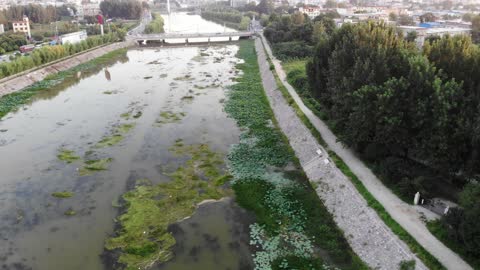
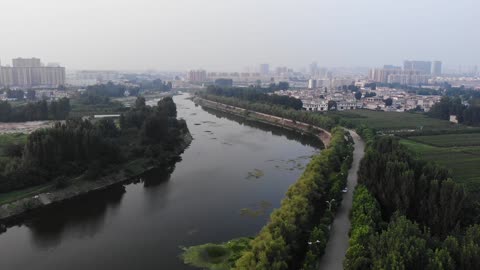
Fangcheng Pan River 潘河 🇨🇳 (2018-08) {aerial}
Aerial views of Pan river 潘河 in suburban Fangcheng, Henan, People's Republic of China.
#river #landscape #scenery #nature #PanRiver #fangcheng #henan #peoplesrepublicofchina #china #evening #trees #water #aerial #uav #drone #dronevideo #recreation #fangchengcounty #asia
1
view
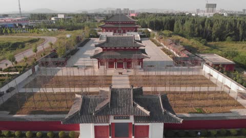
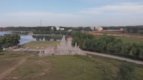
Site of ruins of ancient Zeng state 古缯国遗址 🇨🇳 (2018-09) {aerial}
Aerial views of the site of ruins of ancient Zeng state, Fangcheng, Henan, People's Republic of China
[33°13'25.4"N 112°59'22.0"E]
(2018-09)
#historic #landscape #scenery #architecture #fangcheng #urban #henan #peoplesrepublicofchina #china #city #building #historicsite #aerial #uav #drone #dronevideo #recreation #fangchengcounty
1
view
Fangcheng Cultural Center and Park 🇨🇳 (2018-09) {aerial}
Aerial views of Fangcheng Cultural Center and Park, Fangcheng County, Henan, People's Republic of China (2018-09)
[33°16'11.1"N 113°01'08.7"E]
#architecture #scenery #landscape #urban #fangcheng #henan #peoplesrepublicofchina #asia #aerial #uav #drone #dronevideo
11
views
Shangqiu Sun Moon Lake 🇨🇳 (2018) {aerial}
Impressions of Sun Moon Lake,
Shangqiu City, Henan,
People's Republic of China, [34°22'27.0"N 115°40'08.6"E]
(2018)
Duration: 1h:17m
Author, director, editor, producer, camera person, sound arranger:
Walter M Hagemann
Equipment:
DJI Mavic Air
OnePlus 3T
Xiaomi Ninebot Mini
Editing software:
Shotcut 18.09
#sunmoonlake #shangqiu #henan #peoplesrepublicofchina #recreation #nature #lake #scenery #uav #drone #dronevideo #aerial #park #tourism, #travel
9
views
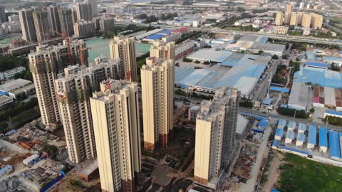
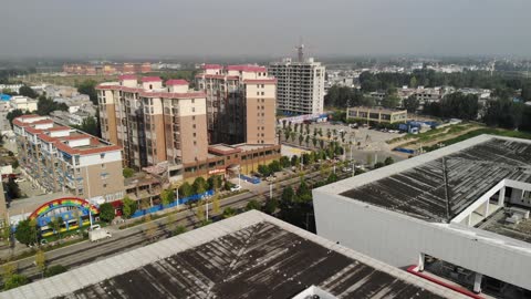
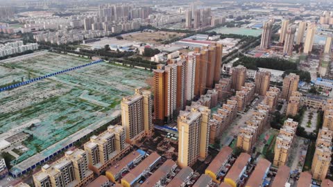
Apartment building construction, Shangqiu 🇨🇳 (2018-05) {aerial}
Aerial view of apartment buildings under construction at Suiyang District, Shangqiu, Henan, People's Republic of China.
#apartmentbuilding #highrise #residential #aerial #uav #drone #dronevideo #shangqiu #henan #peoplesrepublicofchina #asia #architecture #scenery #city
12
views
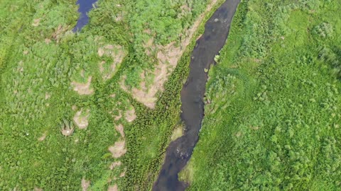
Evening at rural Pan river 潘河 🇨🇳 (2018-08) {aerial}
Aerial views of Pan river in rural Fangcheng, Henan, People's Republic of China.
Sheep are grazing downstream the weir. Birds are in the air and along the creek.
#river #landscape #nature #fangcheng #henan #peoplesrepublicofchina #china #evening #trees #water #aerial #uav #drone #dronevideo #recreation #fangchengcounty
1
view
Evening at suburban Pan river 潘河 🇨🇳 (2018-08) {aerial}
Aerial views of Pan river in suburban Fangcheng, Henan, People's Republic of China.
#river #landscape #nature #fangcheng #henan #peoplesrepublicofchina #china #evening #trees #water #aerial #uav #drone #dronevideo #recreation #fangchengcounty
1
view
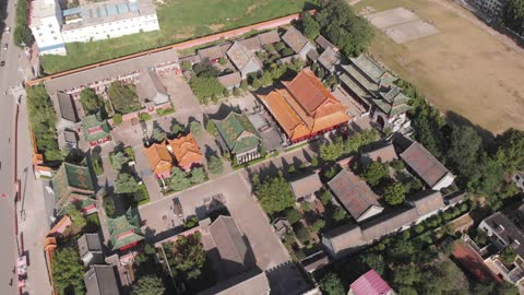
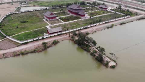
Lianzhen Temple 鍊真宮 🇨🇳 (2018-08) {aerial}
Areal views of (Taoist) Lianzhen Temple (鍊真宮),
Fangcheng, Henan, People's Republic of China (2018-08)
[33°15'56.4"N 112°59'48.6"E]
#temple #fangcheng #henan #peoplesrepublicofchina #asia #architecture #uav #drone #dronevideo #china #aerial
1
view
Apartment buildings, Shangqiu 🇨🇳 (2018-06) {aerial}
Aerial view of apartment blocks in Shangqiu, Henan, People's Republic of China.
#apartmentbuilding #highrise #residential #aerial #uav #drone #dronevideo #shangqiu #henan #peoplesrepublicofchina #asia #architecture #scenery #city
3
views
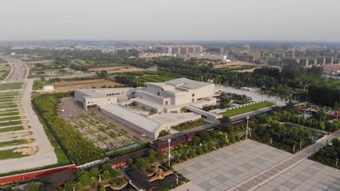
Shangqiu Museum 🇨🇳 (2018-06) {aerial}
Aerial view of Shangqiu Museum, Shangqiu, Henan, People's Republic of China. Architect: Atelier Li Xinggang. Located in the new district in the southwest of the city, Shangqiu Museum is designed for the collection, display and exhibition of the local historical relics, the urban evolution and the cultural history of Shang Dynasty.
[34°21'45.8"N 115°35'12.7"E]
#museum #architecture #scenery #landscape #aerial #drone #uav #dronevideo #building #shangqiu #henan #peoplesrepublicofchina #asia
4
views
Shangqiu South Lake 🇨🇳 (2018-06) {aerial}
Aerial view of the lake adjacent to Suiyang Ancient City, Shangqiu, Henan, People's Republic of China.
[34°22'30.4"N 115°36'19.3"E]
#lake #scenery #landscape #nature #recreation #moat #history #aerial #drone #uav #dronevideo #shangqiu #henan #peoplesrepublicofchina #asia
5
views
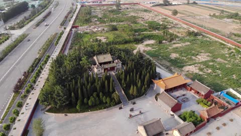
Ebo Tai 阏伯台, the first star observatory of China 🇨🇳 (2018-06) {aerial}
Aerial view of Ebo Tai, Shangqiu, Henan, People's Republic of China. The Ebo Tai preserved today is of tomb shape, 35 meters high, with a 270-meter-circumference. It was built of ramming clay. Tiles and pottery were among tier upon tier of ramming clay, which might come from Han Dynasty. Because of the sand and mud sludge of the Yellow River, the original Ebo Tai is dimly visible under the present one. The dune under Ebo Tai is the place which Ebo conferred as Shangqiu. This is the way Shangqiu gaining its name. Erected on the plain which stretches to the horizon, it looks much taller and loftier. It is the highest point in the ancient Shangqiu towns, along with the thought of ancient people that Ebo Tai complied with Shang Star; it has been regarded as the symbol of Shangqiu since ancient times.
[34°22'04.3"N 115°35'10.8"E]
#ebotai #history #shangqiu #henan #peoplesrepublicofchina #asia #suiyangancienttown #uav #drone #aerial #dronevideo #starobservatory #yanbotai #historicsite #china
22
views
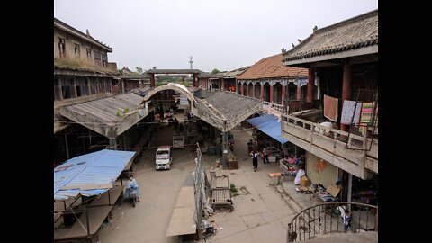
The ancient city of Suiyang 睢阳古城, Shangqiu 🇨🇳 (2018-06) {aerial}
Aerial view of Suiyang Ancient Town (aka Shangqiu Ancient Town), at Shangqiu, Henan, People's Republic of China. The Old Town of Shangqiu is located in the southwest section of the city proper. Dating back to the Ming Dynasty (1368-1644), the brick construction retains great historic and cultural relics, especially in the traditional residential houses and courtyards characteristic of the period. At the time of visit, major redevelopment and reconstruction works were ongoing. Many historic structures being demolished and replaced by look-alike new buildings.
[34°22'58.1"N 115°36'41.4"E]
#suiyan #town #city #historic #ancient #scenery #landscape #redevelopment #reconstruction #oldtown #shangqiu #henan #aerial #uav #drone
5
views
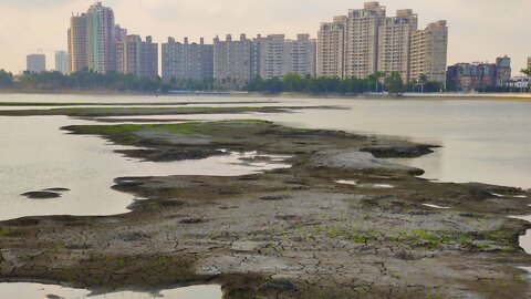
Chengcing Lake 澄清湖風景區 drought 🇹🇼 (2021-04) {aerial}
Views of the low water level of Chengqing Lake, Niaosong District, Kaohsiung City, Taiwan.
Other names and spellings are Chengcing Lake (澄清湖), Chengqing Lake, Cheng Ching Lake, Dabei Lake (大貝湖), or Toapi Lake (大埤湖). The artificial lake has a surface area of ~1.03 km². Effective capacity of the reservoir is 3,370,000 m³. Previously, the lake was used to regulate the irrigation of the surrounding land. Now the lake is a source of the public water supply network (Seventh Branch of Taiwan Water Corporation) and irrigation as well as a recreational area of the Kaohsiung region. Due to lack of precipitation in 2020/early 2021 water level was rather low in 2021 April. The situation was used to carry out dredging works to restore the previous storage capacity of the lake, which was impaired by siltation.
Points of interest (sightseeing):
* Freedom Pavilion 自由亭
* Chiang Kai-shek building 澂清樓 (蔣公行館)
* Shishien 獅子園
* Seven bends bridge 澄清湖風景區 九曲橋
* Taoran Pavilion 澄清湖風景區 陶然閣
* Fengyuan Pavilion 澄清湖風景區 豐源閣
* Tsz Fai Building 慈暉樓
* Flying Statue of Tatsuko 辰子飛翔之像
* Shuanglian Pavilion 雙蓮亭
* Renzhiting 仁智亭
* Jiemeiting 姊妹亭
* Fuguodao 富國島
* Siyuanting 思源亭
* National Army Zhongling Pagoda 國軍忠靈塔
* Zhongxing Tower 中興塔
* Kaohsiung Grand Hotel 高雄圓山大飯店
* Niaosong Wetland Park 鳥松濕地公園
#ChengqingLake #Kaohsiung #Taiwan #scenery #landscape #lake #park #recreation #sightseeing #nature #hotel #aerial #uav #drone #NiaosongDistrict #KaohsiungCity #Asia
Support the channel:
https://www.paypal.com/paypalme/WalterHagemann
Related website:
https://chengcinglake.water.gov.tw/
Music:
Passing Time by Kevin MacLeod
YouTube Audio Library License
9
views