
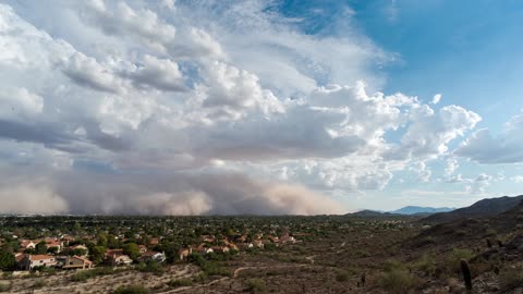
Massive Dust Storm Completely Engulfs City Of Phoenix
More familiar to the desert of Saharan Africa, the first massive dust cloud of the year has engulfed the city of Phoenix cutting off power to many homes and closing the international airport. A giant dust storm has developed across the Phoenix metro area in response to thunderstorms in the region.
Known as a haboob, which is Arabic for 'strong wind', the storm's yellowy <a href="https://rumble.com/v39xm7-dust-storm-rolls-through-zacatecas-mexico.html" target="_blank">grey dust cloud</a> was traveling pretty fast. Caused by Arizona's monsoon season which begins in early June and runs through till the end of September, haboob's only occur in Africa, the Middle East, Australia and Phoenix, Arizona. The haboob temporarily blocked out the sun and covered everything in a layer of dust.
The haboob is a rare event and is caused by loose dust being blown upwards in the absence of rain and collecting skywards where it is then propelled by another more distant thunderstorm brewing behind it. It is destructive because of the fine dust particles that manage to permeate everywhere during the storm. <a href="https://rumble.com/v32aja-dust-storm-covers-southwest.html" target="_blank">The dust gets into everything</a>, into every nook and cranny. It is one thing to see it from the ground, but when you are on top of a mountain and you still have to look up to see the top of it, you really start to grasp the size and magnitude of the haboob.
Dust storms are not naive because they carry a noxious mix of fungi, heavy metals from pollutants, chemicals and bacteria that could lead to cardiovascular and eye disease, and other illnesses.
91.8K
views
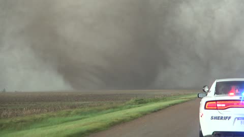
Extreme close range footage of tornadoes in Kansas
A family of tornadoes impacted Ford County around Dodge City, Kansas late last month. Watch as one of them tornado (rated EF-3) rips the roof off of a home with the inflow jet. This amazing supercell produced tornadoes for over 2 hours. Credit: Brett Adair / Live Storms Media
95.3K
views
2
comments
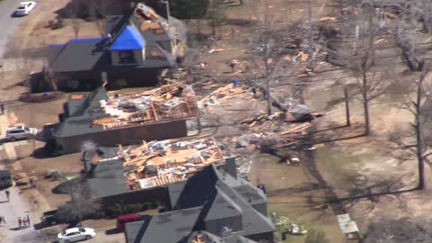
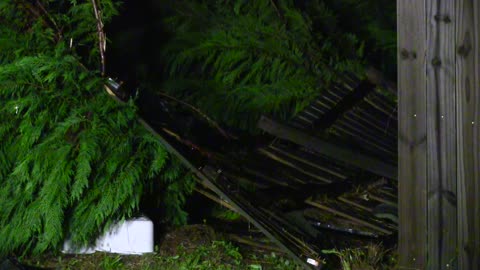
Aerial footage captures magnitude of Alabama tornado damage
Live Storms Media Meteorologist Brett Adair flew over the EF-2 tornado damage path in Bessemer just one day after the tornado tore a path through town. The aerial views are just south of I-459 where the Bentbrook Golf Course is located. The heaviest damage was noted on Pocahontas Road, Dickey Springs Road, and Pine Valley Drive where the roof of some homes were completely removed. The tornado was rated an EF-2 by the National Weather Service with 125 mph winds. Credit: Brett Adair / Live Storms Media
10.4K
views
3-1-16 Bessemer, Alabama Tornado Damage - Ground - Bentbrook Area
Tornado damage from the March 1st 2016 tornado near Bessemer and the Bentbrook Golf Course.
Credit: Brett Adair / Live Storms Media
10
views

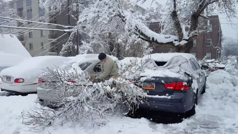
Heavy snow makes it difficult for driving in Colorado Springs, CO
Heavy snow has impacted parts of Colorado as a major winter storm ejects out of the Rockies and moves into the Plains states. Cars can be seen having trouble on the roadways as sliding is common, with the snow blowers cranked and rolling. Over one foot of snow has fallen and it is still continuing. Credit: Jessica Moore / LSM
1.55K
views
Southwest Atlanta Tornado Damage
Severe storms rolled through the Atlanta area on Wednesday spawning tornadoes just southwest of town. The town of Palmetto was hit pretty hard on Lea Way where several homes were damaged. Luckily, no injuries occurred.
Credit: Brett Adair / Live Storms Media
809
views
Salt Lake City pounded by damaging winter storm
A significant winter storm is pounding portions of Utah and the mountains with tremendous snowfall over 2 feet in certain locations. Trees and powerlines can't hold the weight of the snow and are falling and causing damage. Snow will continue into the evening and more damage is possible due to weight issues overnight. Credit: Darin Brooks / Live Storms Media
8.32K
views

Hotel in Dallas lights up in support of France
The Omni Hotel in Dallas, Texas, lights up over the weekend in the colors of the French flag. This is a symbol of unity spread across the world following the deadly Paris terrorist attacks the took over 100 lives on Friday. Credit: Nick Busby / Live Storms Media
18.2K
views
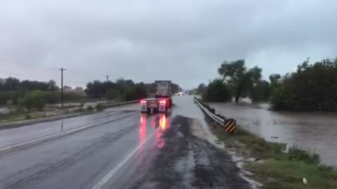
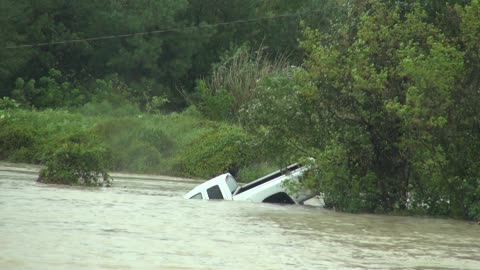
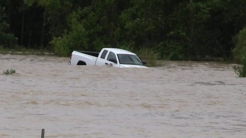
San Marcos, TX area flooding
Significant flash flooding event is unfolding across Central Texas this morning. Live Storms Media is on the scene as conditions deteriorate. Flash flood emergencies are in place across the region between San Antonio and Austin.
5.07K
views
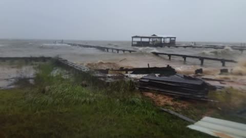
Fort Morgan, Alabama coastal flooding
A powerful low along the coast line brought rounds of heavy rain, high winds, and tidal flooding on the Alabama beaches and inlets. Flooding has continued to take place and will begin to subside as we move through the week and the low pressure system moved north. Credit: Heather Smith / Live Storms Media
982
views
Mississippi town hit hard by coastal storm
The powerful coastal storm which was ex-Hurricane Patricia moved through the Gulf of Mexico before heading inland across Louisiana early this week. Large waves, heavy rain, and flash flooding were a problem on the Mississippi coast, especially for the town of Pascagoula as seen in this footage. Credit: Tiffany Strunk / Live Storms Media
8.38K
views

Balloon festival in Montague, California
One year after wildfires postponed the balloon fest, it's back underway in Montague, California on this Saturday in September. Cool and calm conditions with no fire in sight in the area. Credit: David Plank / Live Storms Media
381
views
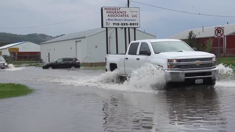
Council Bluffs, Iowa flash flooding & damage
Flash flooding occurred overnight in the Council Bluffs area that had a radar indicated 8 inches of rainfall. Severe thunderstorms in the same area also downed some large tree branches and caused roof damage in the area. Credit: Evan Ludes / Live Storms Media
2.53K
views
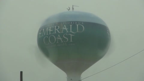
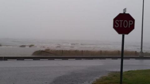
Fort Walton Beach, Florida flash flooding
Significant rainfall amounts today of 6-12 inches are causing a fairly significant flooding situation along the Emerald Coast. Santa Rosa Boulevard in Fort Walton Beach is essentially under water with 1-2 feet of water across it. Cars moving through the area are creating white caps with some cars already reported to have stalled out. More rain is falling and a flood warning is in effect through the evening. Credit: Brett Adair / Live Storms Media
1.38K
views
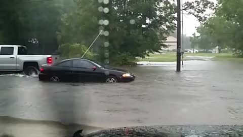
Pascagoula, Mississippi flash flooding
Flooding was no match for a few vehicles who decided to go through waters of 1 to 2 feet deep in parts of Pascagoula on Sunday. Even a motorcycle went through the water like it was nothing. However, you don't know if there are pockets of deeper water when you do this. Please, turn around and don't drown. Credit: Tiffany Strunk / Live Storms Media
1.41K
views
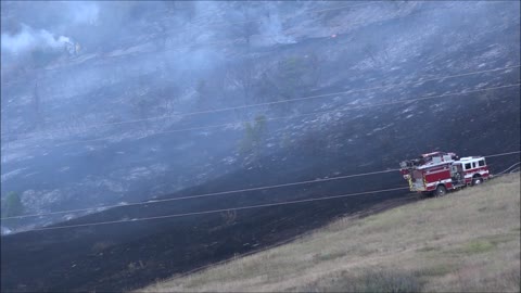
10-14-15 Jefferson County, Colorado Fire
A large fire broke out across portions of the Southwest Denver metro charring a large stretch of hillside. Multiple units responded and the east bound lanes of C-470 highway were closed in Ken Caryl, Colorado. Helicopters moved in to drop water from a nearby lake onto the fire which was eventually contained. Credit: Max Olson / Live Storms Media
669
views

Destin, Florida significant flash flooding
Significant flash flooding took place during the evening on September 28th across portions of Walton and Okaloosa Counties. Destin proper ended up receiving over a foot of rainfall and the drainage system could not handle it. Many roads ended up with deep water and stalled vehicles in them, including US-98 and FL-293 near the Mid-Bay Bridge. Credit: Brett Adair / Live Storms Media
1.71K
views

Fall in Iowa delivers stunning beauty
Fall colors come around across portions of eastern Iowa. These shots were taken east of Des Moines in mid October. Beautiful! Credit: Danny Murphy / Live Storms Media
11.8K
views
10-4-15 Columbia, SC Gills Creek Water Rescue
A vehicle drives around the barricade at I-77 and Bluff Road and drives into Gills Creek that is over the roadway. The record flood for Gills was 9.1 feet...which was smashed by the flood on Sunday. The river gauge hit 17.1 feet before breaking and being carried down stream. This video features the truck floating down stream....a good samaritan swimming out to the vehicle and knocking the window out to get him out of the cab....and the ensuing swift water rescue team that moves in to rescue the two that are in the bed of the white pickup truck.
Credit: Brett Adair / Live Storms Media
1
view
Truck swept down stream in Columbia, South Carolina
Dramatic footage of a vehicle that was swept off of Bluff Road at Gills Creek after driving around barricades into flood waters. The gentlemen who also swept down stream was eventually rescued and luckily lived to see another day. Credit: Brett Adair/Live Storms Media
83.1K
views
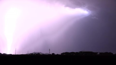
Incredible cloud-to-ground lightning storm
Bryan Snider, from Live Storms Media, captures these stunning cloud-to-ground lightning strikes near Phoenix, Arizona. It's amazing how beautiful an intense a storm can be.
53.7K
views
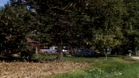
Have you ever seen a corn stalk tornado?
Shae Cohan, from Live Storms Media, captures a 'mini tornado' tearing across a freshly plucked field of corn in Shelbyville, Illinois. Dry stalks are lofted into this rather wide dust devil, which eventually pelted his windshield and vehicle. Crazy!
28.1K
views
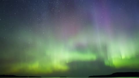
Stunning time lapse shows Northern Lights over Great Lake
Robert Hoff, from Live Storms Media, captured a gorgeous timelapse of the northern lights from Munising, Michigan over Lake Superior. What an incredible sight! Credit to 'Robert Hoff/Live Storms Media'.
7.99K
views
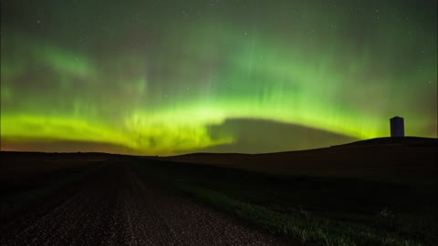
Northern Lights Shine Bright Over North Dakota
It is one of those sights that many think is only obtainable if they travel to the northern parts of the planet. An aurora, sometimes referred to as polar lights, northern lights or southern lights, is a natural light display in the Earth's sky, predominantly seen in the high-latitude regions. But in recent years the gorgeous Aurora Borealis can also be seen in some remote parts of continental US.
Zach Hargrove, from Live Storms Media, captured absolutely stunning shots of the <a href="https://rumble.com/v3zc1f-stunning-northern-lights-captured-over-lapland.html" target="_blank">nothern lights</a> over North Dakota.
Here’s a little science for you. Auroras are produced when the magnetosphere is sufficiently disturbed by the solar wind that the trajectories of charged particles in both solar wind and magnetospheric plasma, mainly in the form of electrons and protons, precipitate them into the upper atmosphere due to Earth's magnetic field, where their energy is lost. The resulting ionization and excitation of atmospheric constituents emits light of varying color and complexity.
That is why the Aurora shows different colors in different parts of the world. In the northern countries, it may show varying shades of blue, purple and green. Lower, it shows only the green spectrum.
In northern latitudes, the effect is known as the aurora borealis or the northern lights. The southern counterpart, the aurora australis or the <a href="https://rumble.com/v38idj-stunning-timelapse-of-southern-lights-captured-over-scenic-lake.html" target="_blank">southern lights</a>, has features almost identical to the aurora borealis and changes simultaneously with changes in the northern auroral zone. The Aurora Australis is visible from high southern latitudes in Antarctica, Chile, Argentina, New Zealand, and Australia.
Credit: Zachary Hargrove/Live Storms Media.
75.2K
views
Time lapse: Stunning Supercell in Wellsville, Kansas
David Patterson, from Live Storms Media, captured this gorgeous supercell Friday September, 18th in eastern Kansas near Wellsville. This supercell tornado was captured in timelapse as it spun from eastern Kansas into western Missouri before eventually being undercut by a cold frontal boundary. Credit: Live Storms Media / David Patterson.
4.82K
views