

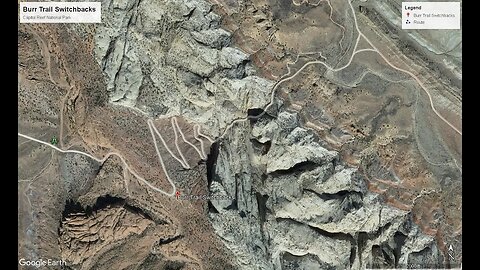
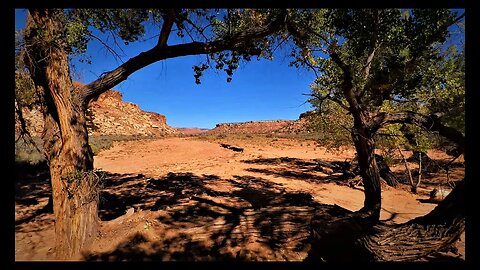
Burr Trail Switchbacks in Capitol Reef National Park
Burr Trail Switchbacks
The Burr Trail Switchbacks is in Garfield County Utah and are one of the few passages across the Grand Staircase, a geological formation which greatly vexed early stagecoach travelers crossing the plains.
At this tectonic boundary (known as a monocline or more commonly known as the “Waterpocket Fold) the western plate juts sharply above the eastern plate, presenting a largely unbroken wall-like barrier nearly 100 miles long. This generally insurmountable wall of rock is positioned within Glen Canyon National Recreation Area, Capitol Reef National Park, and Grand Staircase-Escalante National Monument (Which encompasses the largest land area of all U.S. National Monuments, slightly larger in area than the State of Delaware).
The switchbacks and the road were named after John Atlantic Burr (He was born in 1846 while crossing the Atlantic thus his middle name Atlantic) and lived with his family in Salt Lake City before moving south to establish the town of Burrville, Utah in 1876. He established the Burr Trail across extremely rugged territory, including Waterpocket Fold, Burr Canyon, and Muley Twist Canyon as a way of moving cattle between lower winter grazing ranges on the east side of Waterpocket Fold and higher summer grazing ranges on the west.
The section of the Burr Trail within Capitol Reef National Park is still unpaved and is in a scenic but isolated section of an already remote National Park that can be reached via Utah Scenic Highway 12 or from the Notom-Bullfrog Road.
(Source https://www.atlasobscura.com/places/burr-trail-switchbacks)
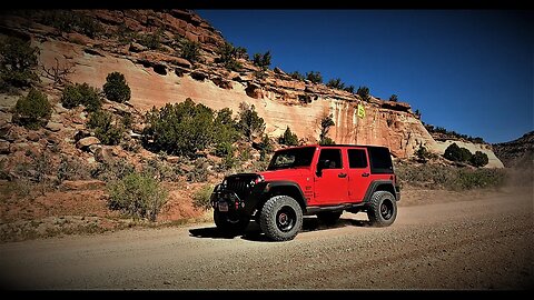
Please note: Although in dry weather the Burr Trail is easily accessible to passenger cars, wet weather may make the road impassable even for 4-wheel drive vehicles. Check with rangers or local officials for weather and road conditions. Recreational Vehicles and trailers are not recommended.
Originally, only the switchbacks were named the Burr Trail, a route used by cattleman in the late 19th century to move cattle back and forth between winter and summer ranges.
Today, the entire road from Bullfrog to Boulder is known as the Burr Trail.
To access a 16-page PDF produced by the National Park Service follow this link:
https://www.nps.gov/glca/planyourvisit/upload/BurrTrailDrivingGuide2019_508.pd
The Burr Trail and the Switchbacks in the Capitol Reef National Park do
offer some of the most eye-popping scenery of any drive in Southern Utah, the 67-mile Burr Trail twists and turns from the town of Boulder all the way to tiny Bullfrog, which lies at the tip of one of the many fingers of Lake Powell, within Glen Canyon National Recreation Area. Only an 8½-mile stretch of Burr Trail passes through Capitol Reef National Park, but it's arguably the most spectacular section. It's especially dramatic if approaching from the west from Boulder through Grand Staircase–Escalante National Monument. When you reach the Capitol Reef National Park border, the road becomes unpaved but is still generally (unless there's been heavy rain or snow) passable with a passenger car. It curves through juniper-dotted, red-rock countryside, offering sweeping views of the Strike Valley, the Studhorse Peaks, and—in the distance—the Henry Mountains. After about 3 miles, you'll crest the upper, western ridge of the Waterpocket Fold, a 100-mile-long monocline in the earth's crust, and then zigzag some 800 feet down a series of dramatic switchbacks to the lower end of the fold. From here, Burr Trail Road continues southeast past the junction with Notom-Bullfrog Road (where a left turn leads back up to Torrey) toward the small village of Bullfrog.
24
views
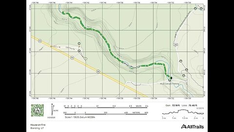
Taste of House on Fire and Mule Canyon Trailhead - Bears Ears National Monument
House on Fire
Location Coordinates:
(37.542504, -109.730760; Parking 37.537314, -109.732772)
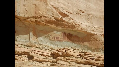
Within the boundaries of Bears Ears National Monument, the House on Fire is one of the region's most popular cliff dwellings that's right along Highway 95 between Blanding and Natural Bridges in the South Fork of Mule Canyon. It's a one-quarter mile drive on well-maintained native-surface road. It's called House on Fire because at certain times of day the lighting makes it looks like there's a glow to it, with smoke and flames coming out of it. It's very popular with photographers. It's a short hike, 3 miles round trip with little elevation so it's good for the whole family.
Time your trip to House on Fire by arriving at the trailhead with enough time to hike the 1.5 miles and hit the ruin approximately late morning, depending on the season. You’ll never forget this magical place lit ablaze with sunlight reflecting off red-orange rock. You’ll also remember the mystery and the wonderment you feel gazing upon ancient structures, pictographs, and petroglyphs.
The Mule Canyon/House on Fire trailhead requires a $2.00 per person permit at trailhead if not purchased in advance at Kane Gulch Ranger Station. Beginning in March 2018, advance reservations for overnight trips in the Bears Ears area may be obtained on recreation.gov or the Kane Gulch Ranger Station. Please visit the BLM Cedar Mesa Permits webpage for more information. Just a FYI...We purchased an annual hiking pass for “Cedar Mesa & Comb Ridge Day Hiking”. It cost us, as of May 2023, $44.50 and is good to the end of May 2024.
Here are some links that will give you some more info:
https://www.youtube.com/watch?v=_BzroGmQ-Ac (Trek Planner)
https://www.hikingproject.com/trail/7021924/house-on-fire-ruins
https://www.visitutah.com/places-to-go/parks-outdoors/bears-ears-national-monument/ancestral-pueblo-cliff-dwellings
https://www.blm.gov/programs/recreation/permits-and-passes/lotteries-and-permit-systems/utah/cedarmesa
P.S. Sorry I haven't figured out how to make these "Real Links" so you will just have to copy and paste these to go to the websites. If anyone knows how to make these real links please let me know...Thanks!
12
views
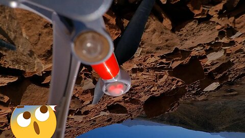
Cactus Hill & "Lesson Learned" Drone Mishap - South Central Utah
Here is what the FAA states in their Part 107 rules about reporting an accident:
When do I need to report an accident?
The remote pilot in command (Which I was) of the small UAS (Unmanned Aerial System) or drone is required to report an accident to the FAA within 10 days if it results in at least serious injury to any person or any loss of consciousness, or if it causes damage to any property (other than the UAS or drone) in excess of $500 to repair or replace the property (whichever is lower). Actual section specifying this is shown below.
Part 107.9 Safety Event Reporting
No later than 10 calendar days after an operation that meets the criteria of either paragraph (a) or (b) of this section, a remote pilot in command must report to the FAA, in a manner acceptable to the Administrator, any operation of the small unmanned aircraft involving at least:
(a) Serious injury to any person or any loss of consciousness; or
(b) Damage to any property, other than the small unmanned aircraft, unless one of the following conditions is satisfied:
(1) The cost of repair (including materials and labor) does not exceed $500; or
(2) The fair market value of the property does not exceed $500 in the event of total loss.
2
views
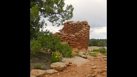
Cave Tower Ruins Part 2 - Bears Ears National Monument
Cave Tower Ruins (aka Mule Canyon Towers)
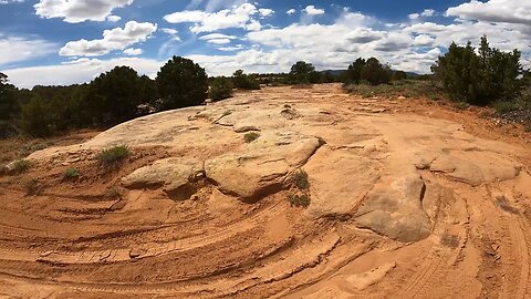
In "Part 2" we hike back from the ruins on the 4-Wheel drive road to the parking lot. We always like to show as much of the "Off-Road" road as we can to show to the viewer what they may encounter on the trail. We obviously didn't drive the road but for those of you that are "Overlanders" we decided to show you the road just in case you wanted to take the Cave Towers Road to set up camp in the area. Be aware, this is now part of Bears Ears National Monument so please check out the rules and regulations for camping in this area before you go. As always, please show respect for the land and the ruins.
There are seven towers in various states of decay located on the left (east) and right (west) sides of the rim. Much of the first story of one of the towers on the east rim is in very good shape. On the west rim a partial wall with a doorway remains. The other towers are basically piles of rubble.
Be sure to walk around to the west rim for view of additional ruins tucked in alcoves and located beneath overhangs along the cliffs on the east/northeast canyon wall. A pair of binoculars or a zoom lens on a camera is helpful to see the details of the structures and spot some of the ruins further down the canyon. One of the ruins is of good size, with the partial remains of several structures and walls.
The Cave Canyon towers were once multi-storied and in the line of sight with the towers at Mule Canyon Archaeological Ruin. The Mule Canyon Ruins, well-preserved Pueblo surface ruins that are thought to be over 700 years old, are located less than a mile West from the Cave Towers trailhead. This ruin complex includes above-ground and underground dwellings. Structures at the site include a Kiva and tower which have been excavated and stabilized as well as a block of twelve rooms. The site includes interpretive signs and toilets. To reach the site when leaving the Cave Towers, turn left (northwest) on Highway 95 and drive 0.8 miles. Turn right on the signed paved access road.
73
views
Cave Tower Ruins Part 1 - Bears Ears National Monument
Cave Tower Ruins (aka Mule Canyon Towers)
There are seven towers in various states of decay located on the left (east) and right (west) sides of the rim. Much of the first story of one of the towers on the east rim is in very good shape. On the west rim a partial wall with a doorway remains. The other towers are basically piles of rubble.
Be sure to walk around to the west rim for view of additional ruins tucked in alcoves and located beneath overhangs along the cliffs on the east/northeast canyon wall. A pair of binoculars or a zoom lens on a camera is helpful to see the details of the structures and spot some of the ruins further down the canyon. One of the ruins is of good size, with the partial remains of several structures and walls.
The Cave Canyon towers were once multi-storied and in the line of sight with the towers at Mule Canyon Archaeological Ruin. The Mule Canyon Ruins, well-preserved Pueblo surface ruins that are thought to be over 700 years old, are located less than a mile West from the Cave Towers trailhead. This ruin complex includes above-ground and underground dwellings. Structures at the site include a Kiva and tower which have been excavated and stabilized as well as a block of twelve rooms. The site includes interpretive signs and toilets. To reach the site when leaving the Cave Towers, turn left (northwest) on Highway 95 and drive 0.8 miles. Turn right on the signed paved access road.
21
views
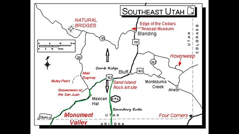
Comb Ridge Wash Trail - Bears Ears National Monument
Comb Ridge
Just a few miles west of Bluff is Comb Ridge, a steep ridge running 80 miles in a north/south direction from Kayenta, Arizona to the foothills of the Abajo Mountains near Blanding, Utah. Tilted at almost 20 degrees and over one mile wide, the name comes from the jagged appearance of the ridge which is similar in shape to a rooster’s comb.
This natural marvel is a classic example of what geologists call a monocline, or a step-like bend of the earth’s rock layers in one direction. This blunt rock extension occurred nearly 65 million years ago, when tectonic plates buried deep under the earth’s surface slipped, leaving a rugged scar across once smooth stone.
Comb Ridge is now protected and form the major part of the Shash Jaa Unit of Bears Ears National Monument.
History
Archaeological surveys of the Ridge have revealed more of the formation’s ancient secrets, from Ice Age camps and 800-year-old Ancestral Puebloan cliff dwellings, to historic artifacts of Anglo settlers, and strange lanes carved into the earth across miles of desert. These are Ancestral Puebloan roads and “Anasazi roads” are believed to connect places of significance.
In 1880, Mormon pioneers on the last leg of their grueling Hole-in-the-Rock trek crossed the structure before settling Bluff. Knowing Comb Ridge was a formidable obstacle, they traveled south along the Comb to the San Juan River. There they built another dugway up the face of Comb Ridge naming it “San Juan Hill”.
Comb Ridge Exploring
Ancestral Puebloans once found refuge in the Comb’s alcoves. Vacationers wishing to explore the rich archeological aspects of the Comb can discover traces of the ancient Ancestral Puebloan culture via ruins and rock art on the canvas of cave walls. Each cleft in Comb Ridge indicates a small canyon created by flash floods that can be accessed from behind the ancient stretch of rock formation.
As you drive west from Bluff on Highway 163, you will cross the Ridge. Two, parallel gravel roads run north/south on either side of Comb Ridge: Comb Wash (County Road 235) to the west of Comb Ridge and Butler Wash (County Road 230) to the east. The roads link to Highway 95 on the north.
Butler Wash has entrances to numerous, short, box canyons which contain rock art and ruins. North of Highway 95 are the Butler Wash Ruins overlook. This is a cliff dwelling built and occupied by Ancestral Puebloans around 1200. Parts of the site have been stabilized and reconstructed. Round trip hiking distance is about 1 mile. Parking and a restroom are available.
Visit With Respect
Comb Ridge is part of the Bears Ears National Monument and, as such,dwelling remains and rock art are extremely fragile and are of important cultural significance. To preserve this important landscape for future generations, visitors should refrain from touching rock art or moving artifacts. Before you go, check out the "Visit with Respect" tips offered by blogger, Erica Tucker.
General Information
Fees: A permit is required from the Bureau of Land Management for hiking for day use and overnight backpacking in Butler Wash. Day use permits (except for Moon House) are available at self-pay locations at some trailheads but a better plan is to obtain a permit for all of Cedar Mesa through https://www.recreation.gov/ and go to the “My Reservation” section. I purchased an annual pass for “Cedar Mesa & Comb Ridge Day Hiking”. It cost me, as of May 2023, $44.50 and is good to the end of May 2024.
Camping: Just south of Highway 95 on Butler Wash is the Comb Wash Campground which features dispersed camping and pit toilets. No water is available. Dispersed camping is also allowed along Comb Wash and Butler Wash. You must stay on previously disturbed areas within 150 feet of designated routes and should not drive off road to create a new campsite. Please do not camp inside ruins. Plan on bringing your own water and to pack out your trash and waste.
BLM Website Links: https://www.blm.gov/programs/recreation/permits-and-passes/lotteries-and-permit-systems/utah/cedarmesa
www.blm.gov/sites/blm.gov/files/documents/files/River%20House%20Ruin.pdf
YouTube video showing the River House Ruins: https://youtu.be/80l98-ukBEQ
Hole-in-the-Rock Trek Remains an Epic Experience in Pioneering
https://historytogo.utah.gov/hole-rock-trek/
Thanks for watching and viewing our channel. It is sincerely appreciated.
Cactus Hill
172
views
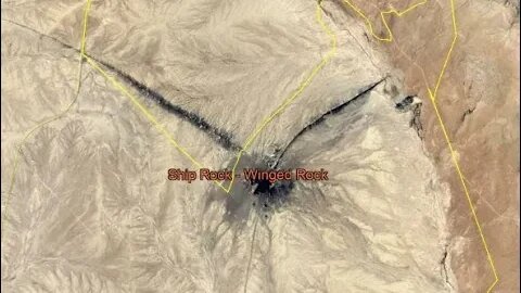
Rock with Wings - Shiprock New Mexico (4 Corners Area)
Ship Rock is a dramatic 7,177-foot-high (2,188-meter) rock mountain located in northwestern New Mexico about 20 miles southwest of the town of Shiprock. The formation, a volcanic plug, rises above a barren desert plain south of the San Juan River. Ship Rock is on Navajo Nation land, a self-governing territory of 27,425 square miles in northwestern New Mexico, northeastern Arizona, and southeastern Utah.
• Elevation: 7,177 feet (2,188 meters)
• Prominence: 1,583 feet (482 meters)
• Location: Navajo Nation, San Juan County, New Mexico.
• Coordinates: 36.6875 N / -108.83639 W
• First Ascent: First ascent in 1939 by David Brower, Raffi Bedayn, Bestor Robinson, and John Dyer.
Ship Rock is called Tsé Bitʼaʼí in Navajo, which means "rock with wings" or simply "winged rock." The formation figures prominently in Navajo Indian mythology as a giant bird that carried the Navajo from the cold Northlands to the Four Corners region when they were being threatened by a more aggressive tribe. Ship Rock, when viewed from certain angles, resembles a large sitting bird with folded wings; the north and south summits are the tops of the wings.
The above text is copied from an article from "Outdoor Trails & Climbs" by Stewart Green. Here is a link to the entire article: https://www.tripsavvy.com/facts-about-shiprock-756148. Also, I found another article about Shiprock on a website called "New Mexico Nomad". Here is a link to that article:
https://newmexiconomad.com/shiprock/
Both of these articles I found very interesting and informative and I highly recommend that you check them out.
One final note...As of 1970 it is illegal to do any rock climbing on "Winged Rock".
42
views
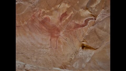
Black Dragon Wash - Upper San Rafael Swell
Black Dragon Pictograph Panel
A mysterious red pictograph (painted) panel accompanied by petroglyphs (pecked images) lies within Black Dragon Wash in the San Rafael Swell. Within a fenced area visitors may view several elongated human and animal like pictograph images attributed to the ancient Barrier Canyon culture. Stylistically different Fremont petroglyphs are located adjacent to the Barrier Canyon pictographs. In the past someone chalked the outlines of the pictograph images, a practice now known to irreparably damage fragile rock art resources. The person chalking the images combined several figures into what appears as a Dragon-like image. This “dragon” gives the canyon its name. Visitors to the site enjoy a short hike to the panel up through the wash and into the San Rafael reef. Nearby canyons and the wash itself provide additional hiking and photography opportunities. The road to the panel is sandy in spots and requires a high clearance vehicle. Do not travel into the area unless you are familiar with desert travel and are aware of the weather conditions.
BLM Info:
Phone: 435-636-3600
Email: utprmail@blm.gov
ADDRESS: 125 South 600 West Price, UT 84501
Directions To Black Dragon Wash Road:
The turn off for Black Dragon Pictograph Panel is approximately 13 miles west (Mile Post 147 when traveling West from Green River) on Interstate 70 from Green River, UT.
The following was copied from an article “Controversial Interpretations of the Black Dragon Pictograph” by Jeff Mitton (Published 12/08/2020)
In 1947, John Simonson published a paper describing his application of chalk to clarify the size and shape of what he perceived to be a large, winged monster. Several decades later a geologist expressed his impression that the pictograph resembled a pterodactyl. In the late 1990s young-earth creationists, who believe that earth is between 6,000 and 10,000 years old, started using the black dragon pictograph as evidence that pterodactyls and Native Americans lived at the same time.
When experts in the Barrier Canyon style of pictographs and petroglyphs looked at the panel, they saw five separate figures, not one dragon."
Evolutionary biologists have found fossil evidence of 110 species of pterosaurs, with wing spans ranging from 10 inches to over 33 feet. Pterosaurs, including pterodactyls, persisted for 150 million years but none of the species survived the meteor strike that triggered the extinction of all the large dinosaurs 65 million years ago. Genetic data enabled evolutionary biologists to estimate that the first fully modern humans lived in southern Africa 200,000 years ago.
When experts in the Barrier Canyon style of pictographs and petroglyphs looked at the panel, they saw five separate figures, not one dragon. Convinced the pterodactyl interpretation of the pictograph was incorrect, archeologists studying rock art used two techniques to critically examine the Black Dragon Panel and to put the controversy to rest.
The first technique was Dstretch, a digital imaging tool designed to enhance photographs of pictographs. It is capable of revealing the presence of pigments faded to the point that they are no longer visible to the human eye. The second technique was x-ray fluorescence, which measures the iron concentration in the red pigment, to clearly discern exactly where Native Americans applied pigment on rock surfaces. Each of these techniques produces results independent of the preconceived notions of the user. Dstretch and x-ray fluorescence were in agreement in their resolution of the Black Dragon Panel into five separate pictographs. On the left are two small figures, a bighorn sheep and a dog. Next is a large, bug-eyed anthropomorph with a snake in its hand. Further to the right is the figure of a man, bent at the waist with arms outstretched in supplication. The last figure to the right is a large, sinuous horned snake. All five figures are characteristic of the Barrier Canyon Style, which was used from 4,000 to 1,500 years ago, and was named for a series of rock art panels along Barrier Creek, just 45 miles away.
In the 1940s, Simonson misinterpreted a pictograph that had faded from thousands of years of sunlight, rain and accumulation of salt scale. Then he “Chalked” the outline of what he thought he saw. His imagination turned the figure of a supplicating man into the neck, head, and beak of a monster. In the 1970s the chalk outline suggested a pterodactyl to an innocent geologist and in the late 1990s that suggestion was embraced uncritically by young-earth creationists motivated by a religious agenda.
It would be grand if Native Americans saw pterodactyls with wingspans exceeding 33 feet soaring in the sky, but it never happened. All the pterodactyls were gone 65 million years before the first modern humans arose.
Link to the Full Article by Jeff Mitton:
https://www.colorado.edu/asmagazine/2020/12/08/controversial-interpretations-black-dragon-pictograph
123
views
Temple Mountain Road Outbound from Reds Canyon Loop - Lower San Rafael Swell
Temple Mountain Road is the superhighway of the lower San Rafael Swell. While a great drive in itself, the bonus is it connects to many of the smaller adventure and sightseeing trails like Swasey's Cabin, Behind the Reef , North Temple Wash, Red’s Canyon Loop, Hidden Slendor and more. Around every curve, Temple Mountain Road offers breathtaking views of the colorful geology for which the San Rafael Swell is renowned. It's easy to see how the road got its name when looking at its namesake sandstone monolith. Ancient pictograph panels painted on shaded alcove walls beckon you to ponder both their meaning and the lives of those who created them centuries before. Camping opportunities are abundant along Temple Mountain Road and the numerous side trails. The short paved section on the eastern end of the road branches off to the whimsical Goblin Valley State Park. Temple Mountain Road is an easy drive with a tremendous payoff so it is a must do if you are in the area.
Highest Elevation: 6869 Ft
Length: 29 Miles
Road Conditions: Graded Dirt/Gravel/Short Paved Section
Road/Trail Difficulty: A-Easy
And remember as I always say…"You won’t know if you don’t go!"
Thanks for watching, take care and be safe out there!
4
views
Reds Canyon Loop Part 3 - Lower San Rafael Swell
"Reds Canyon Loop" is an incredibly gorgeous trail in the south end of the San Rafael Swell in Central Utah. Starting at a high elevation, you can see the beautiful canyon that you will be descending into. Once in the canyon, you can see where the trail gets its name. Winding through the red cliffs, you will wish you could spend days down here. As you exit the trail to the north, you are treated with more spectacular views of the surrounding areas. This is an absolute must do in the Swell!
Highest Elevation: 6905 Ft
Length: 26 Miles
Road Conditions: Graded Dirt/Gravel
Road/Trail Difficulty: B-Easy
Emery County Road: 1019
Baptist Draw Overlook
I have no information on the road out to the overlook but, Baptist Draw is often touted as one of the best beginner friendly canyons in the San Rafael Swell for "Canyoneering". A short approach, coupled with great narrows, easy down-climbs, and straight forward rappels make this a winner. It doesn't hurt that it has some of the deepest, darkest narrows in the Swell. Baptist draw is not typically a hiking trail but here is a link to a YouTube video of a gentleman doing a hike at least initially https://youtu.be/ir7ETbj-LvY. It is considered a class 3 "Canyoneering" route requiring appropriate gear and skills including ropes for rappelling. Baptist Draw has 4 rappels, ending in a fun 80 ft rappel into Upper Chute Canyon. Upper Chute and the ascent out is a beautiful but very, very long. After leaving the canyon is where a map and navigation skills come into play finding your car. Also, Baptist Draw is NOT a good canyon to do in the winter. With a large drainage area, it can hold mud and water for long periods. Couple that with cold temperatures and the short days of winter, and you have a recipe for disaster. Many of the accidents have been cold water and/or short day related. Save this canyon for spring, summer, or fall. Because of the large drainage area, it has a very high flash flood danger. Do not enter if rain is in the forecast. Please reference the following link to AllTrails.com to get more info: https://www.alltrails.com
The San Rafael Swell, however, is an enormous geologic feature, located on 2,000 square miles of BLM land slightly southeast of the center of Utah. The Swell is bisected by Interstate 70; otherwise, it hardly contains a trace of man. It is a vast, open, remote landscape dotted by the mesas and rock towers that are the quintessential formations of the Utah desert. Explore it up close on the network of roads south of I-70 within the Swell, like McKay Flat and Hondu Arch Roads.
To get to McKay Flat Road and then to Hondu Arch Road — which leads to the impressive Hondu natural arch on the west side of the southern Swell — take Temple Mountain Road (Exit 131 off of I-70). There will be several junctions with smaller roads along the way — stay on the main road. After about 10 miles you’ll reach the junction of Heart of Sinbad Road, where you will continue west. About 3.5 miles later, you will reach McKay Flat Road. From here, it is 18 miles to the Hondu Arch. Continue south until McKay Flat Road intersects with Hondu Arch Road, which you will take to the west.
The journey will take you past fierce, beautiful landscapes with rock towers, mesas, and arches that expose the colorful rock layers of the Swell, from the limestone and sandstone of the Permian, to the shale and mudstone of the Cretaceous. You will also pass by one old uranium mine before reaching a stunning view of the Hondu (also spelled “Hondoo”) Arch, a keyhole formation at the road’s end.
When they are in good condition these roads are fit for passenger cars — but check out the current conditions and the weather report before you go because storms can render them impassable. Remember that if something goes wrong you could be a long way from help: make sure your car is running well, that you’ve got a full tank of gas, and bring a good map. Also, watch out for grazing cattle (sometimes they hang out on the roads). Otherwise, enjoy the seemingly otherworldly scenes of the Swell — as well as the solitude of the desert.
50
views
Reds Canyon Loop Part 2 - Lower San Rafael Swell
"Reds Canyon Loop" is an incredibly gorgeous trail in the south end of the San Rafael Swell in Central Utah. Starting at a high elevation, you can see the beautiful canyon that you will be descending into. Once in the canyon, you can see where the trail gets its name. Winding through the red cliffs, you will wish you could spend days down here. As you exit the trail to the north, you are treated with more spectacular views of the surrounding areas. This is an absolute must do in the Swell!
Highest Elevation: 6905 Ft
Length: 26 Miles
Road Conditions: Graded Dirt/Gravel
Road/Trail Difficulty: B-Easy
Emery County Road: 1019
The San Rafael Swell, however, is an enormous geologic feature, located on 2,000 square miles of BLM land slightly southeast of the center of Utah. The Swell is bisected by Interstate 70; otherwise, it hardly contains a trace of man. It is a vast, open, remote landscape dotted by the mesas and rock towers that are the quintessential formations of the Utah desert. Explore it up close on the network of roads south of I-70 within the Swell, like McKay Flat and Hondu Arch Roads.
To get to McKay Flat Road and then to Hondu Arch Road — which leads to the impressive Hondu natural arch on the west side of the southern Swell — take Temple Mountain Road (Exit 131 off of I-70). There will be several junctions with smaller roads along the way — stay on the main road. After about 10 miles you’ll reach the junction of Heart of Sinbad Road, where you will continue west. About 3.5 miles later, you will reach McKay Flat Road. From here, it is 18 miles to the Hondu Arch. Continue south until McKay Flat Road intersects with Hondu Arch Road, which you will take to the west.
The journey will take you past fierce, beautiful landscapes with rock towers, mesas, and arches that expose the colorful rock layers of the Swell, from the limestone and sandstone of the Permian, to the shale and mudstone of the Cretaceous. You will also pass by one old uranium mine before reaching a stunning view of the Hondu (also spelled “Hondoo”) Arch, a keyhole formation at the road’s end.
When they are in good condition these roads are fit for passenger cars — but check out the current conditions and the weather report before you go because storms can render them impassable. Remember that if something goes wrong you could be a long way from help: make sure your car is running well, that you’ve got a full tank of gas, and bring a good map. Also, watch out for grazing cattle (sometimes they hang out on the roads). Otherwise, enjoy the seemingly otherworldly scenes of the Swell — as well as the solitude of the desert.
23
views
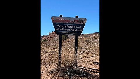
The Wolverine Loop - Grand Staircase Escalante National Monument in Utah (Part 2)
The Wolverine Loop is comprised of 26 miles of dirt road. The road can be a little rough in some sections with what I call “Washlets”. These are small washes across the road that are a few inches wide and can be anywhere from 1” to 6” deep or deeper. They are plentiful along the road so pay attention. There are also major washes along the road as well. You will cross a dozen or more but they are usually dry and not too difficult to get though. Just about any four wheel, all-wheel, or even a two-wheel drive vehicle (With some clearance such as a truck) can handle this trail. It should be noted that no collecting of petrified wood is allowed in the entire region. Along the trail, there are three side canyons which you can explore: 1) Horse Canyon, 2) Wolverine Canyon and 3) Little Death Hollow Canyon. All three of these canyons do not allow vehicular traffic. At the Horse Canyon Trail Head, it is tempting to continue with off-road vehicles, but the trail marker clearly shows (I am told) that only horses and hiking are allowed. Wolverine Canyon has extensive petrified wood. Just to the east of Wolverine Canyon along the trail is a camp site by a dry creek which has many petrified wood blocks. It is worth the stop.
The Wolverine Petrified Forest can be accessed from the loop road (The entrance is shown in Part 2). It is approximately 12± miles from the Eastern entrance of the Burr Trail Road. Scientists are always using this entire area to determine what happened on Earth 250 million years ago. Some believe the planet was tilted differently and Utah was actually very near the Equator. They believe the area was hot, swampy, and humid. A lot of the fossils found within the Wolverine Petrified Forest support that theory .
Here is a website address for more information:
https://www.blm.gov/sites/blm.gov/files/documents/files/BLMUtahBurrTrailandWolverineLoopRoad.pdf
41
views
The Wolverine Loop - Grand Staircase Escalante National Monument in Utah (Part 1)
The Wolverine Loop is comprised of 26 miles of dirt road. The road can be a little rough in some sections with what I call “Washlets”. These are small washes across the road that are a few inches wide and can be anywhere from 1” to 6” deep or deeper. They are plentiful along the road so pay attention. There are also major washes along the road as well. You will cross a dozen or more but they are usually dry and not too difficult to get though. Just about any four wheel, all-wheel, or even a two-wheel drive vehicle (With some clearance such as a truck) can handle this trail. It should be noted that no collecting of petrified wood is allowed in the entire region. Along the trail, there are three side canyons which you can explore: 1) Horse Canyon, 2) Wolverine Canyon and 3) Little Death Hollow Canyon. All three of these canyons do not allow vehicular traffic. At the Horse Canyon Trail Head, it is tempting to continue with off-road vehicles, but the trail marker clearly shows (I am told) that only horses and hiking are allowed. Wolverine Canyon has extensive petrified wood. Just to the east of Wolverine Canyon along the trail is a camp site by a dry creek which has many petrified wood blocks. It is worth the stop.
The Wolverine Petrified Forest can be accessed from the loop road (The entrance is shown in Part 2). It is approximately 12± miles from the Eastern entrance of the Burr Trail Road. Scientists are always using this entire area to determine what happened on Earth 250 million years ago. Some believe the planet was tilted differently and Utah was actually very near the Equator. They believe the area was hot, swampy, and humid. A lot of the fossils found within the Wolverine Petrified Forest support that theory .
Here is a website address for more information:
https://www.blm.gov/sites/blm.gov/files/documents/files/BLMUtahBurrTrailandWolverineLoopRoad.pdf
62
views

Upper Muley Twist Canyon Trail in Capitol Reef National Park
Upper Muley Twist Canyon cuts lengthwise along the spine of the "Waterpocket Fold" creating a colorful, meandering canyon. The Navajo and Wingate sandstone layers are exposed here, tilted by the uplift and folding of the Earth's crust and sculpted by millions of years of erosion. The Wingate, stripped of its protective Kayenta cap rock, has eroded into unusual forms including many large arches. We took the 3 mile section of the road/trail (Accessed from the Burr Trail Road) that is open for vehicles to the "Strike Valley Overlook" trailhead (Hiking Only) which provides outstanding views of the Waterpocket Fold and the surrounding area. The rim route which continues on North is hiking only and provides similar views. Highlights of the drive/hike are narrow canyons, expanses of slick-rock, large arches, and dramatic vistas from the top of the Waterpocket Fold. The route is marked with rock cairns and signs, but carrying a topographic map if hiking is recommended. It is extremely hot in summer and water sources are unreliable so carry adequate water. Use caution in narrow canyons, particularly during the flash flood season (typically July-September). Free back-country permits are required for all overnight hiking trips and can be obtained at the visitor center. This route is not an official, maintained trail. Route conditions, including obstacles in canyons, change frequently due to weather, flash floods, rockfall, and other hazards. Route-Finding, navigation, and map-reading skills are critical. Do not rely solely on unofficial route markers (rock cairns, etc.); they are not maintained by the National Park Service (NPS), may not indicate the route in this description, or may be absent.
Here are a couple of links to obtain more information to the "Lower Muley Twist Canyon" trail that I mentioned in the video. Also, the last link has some important info on the "Monsoon Season" in this area.
https://www.nps.gov/care/planyourvisit/lowermuley.htm
https://www.nps.gov/care/planyourvisit/upload/Lower-Muley-May15-low-res-locked-for-web-2.pdf
https://www.nps.gov/articles/monsoon-season.htm
For further information Contact the Capitol Reef Visitor Center at 435-425-4111
11
views
Montezuma Creek Road in Southeast Utah
Hello and welcome to another Cactus Hill Adventure.Today we are exploring Montezuma Canyon Road in Southeast Utah near the city of Blanding, Utah. “MCR” is a well-maintained county dirt/gravel road with a designation of San Juan County Road 187. Almost any vehicle can drive this road, but I would recommend some type of SUV or Truck with a little ground clearance. There are two main places of interest along the road…The “Bradford Canyon Ruins” and “The Three Kiva Pueblo” site. Other areas of interest, but they are smaller in size, are “Honeycomb Ruins” and “Hidden Ruins”
There are multiple ways to get to the Bradford Canyon Ruins and the 3 Kiva Pueblo via the Montezuma Canyon Road depending upon your direction of travel. We came from the North on US Hwy 191 so I will give you those directions. Turn off US Hwy 191 approximately 5 miles south of Monticello just 1/10 of a mile past mile marker 67 and turn left onto the dirt/graveled Montezuma Canyon Road. You will then travel approximately 25 miles to the Bradford Ruins. Although, along the entire route (Approximately 42 Miles) there are multiple cliff dwellings, granaries, and petroglyphs all up and down Montezuma Canyon so keep a sharp look out for these areas. We used a book entitled “Utah Backcountry Adventures” by Peter Massey and Jeanne Wilson and they have an extensive write-up on this area. They have books and maps for most of the Western United States and their website is https://4wdbooks.com.
The “Three Kiva Pueblo”, that is further South down the road past the Bradford Canyon Ruins, is the most prominent ruin with the Bradford Canyon Ruins a close second. Please watch our video “Three Kiva Pueblo – Southeastern Utah” on this same channel and I will include a link to it at the end of this video. Unfortunately, due to “Operator Error” (Me) the GoPro footage South of the Bradford Canyon Ruins was filmed in “Time Lapse” mode and is unusable…Sorry. I have included some still photos of places of interest past the BCR and they are arranged in “Travel Order”. If you do decide to take this adventure plan on a full day.
One more item of note…I have included all the “Road” GoPro video up to the Bradford Canyon Ruins and most of it is at 20X speed. I wanted to show the road conditions to show you that this is a decent dirt/gravel road and also let you know that the first 15 miles or so is inhabited with “Modern” dwellings with a lot of private property on both sides of the road.
We enjoyed this adventure and took time to stop and explore along the way and we recommend that you do the same. Take care and hope to see you out there on our next adventure and remember “You won’t know if you don’t go!”.
Links:
https://www.americansouthwest.net/utah/montezuma-canyon/index.html
https://www.americansouthwest.net/utah/montezuma-canyon/photographs.html
61
views
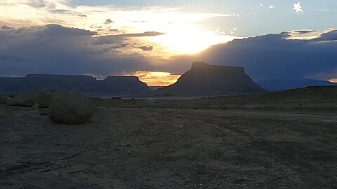
Sunset @ Skyline View View Overlook @ Factory Butte Near Hanksville Utah
The Skyline View Overlook is kind of a hidden gem near the Factory Butte area off of Utah Highway 24 between Capitol Reef National Park and Hanksville, Utah. We had been in the area several times before we finally ran across it a couple of years ago. It is a relatively short trip from Hwy 24 but a high clearance 4-Wheel drive vehicle is recommended but not required (We saw a Dodge Charger out there the last time we went). Anyway, have at least some type of SUV
6
views

Sunset @ Skyline View View Overlook @ Factory Butte Near Hanksville Utah
The Skyline View Overlook is kind of a hidden gem near the Factory Butte area off of Utah Highway 24 between Capitol Reef National Park and Hanksville, Utah. We had been in the area several times before we finally ran across it a couple of years ago. It is a relatively short trip from Hwy 24 but a high clearance 4-Wheel drive vehicle is recommended but not required (We saw a Dodge Charger out there the last time we went). Anyway, have at least some type of SUV
3
views
Mollys Castle - Hanksville Utah Area in 4K
This video shows us traveling from Utah Highway 24 heading West towards Mollys Castle. Mollys Castle is a remote 5,265-foot elevation summit located near Goblin Valley State Park, in Emery County, Utah (South Central Utah, North of Hanksville approximately 20 Miles). Mollys Castle is situated 2.3 mi east of Wild Horse Butte, and one-half mile outside the park's east boundary. The top of this magnificent butte rises 265 feet above its surrounding terrain. Precipitation runoff from Mollys Castle enters the Colorado River drainage basin.
3
views

St George, Utah Drive & Fly @ Val Wash - An Off-Road Adventure
This video was taken within 10 minutes of my home in St. George, Utah. I used "GoPro" footage on the "Drive" portion and "UAV (Drone)" footage on the "Fly" portion. For those of you that are not familiar with Southern Utah & St. George it is in the Northern Mojave Desert at the "3 Corners" where Arizona, Nevada and Utah come together. An "Off-Road" mecca second only to Moab, Utah. It is a beautiful area full of geological wonders and no video or photography can do it justice. I hope you enjoy the video and the scenery is much better that the videographer. Safe travels on all of your adventures and remember..."You won't know if you don't go!"...Cactus Hill
19
views

Baaaad Traffic jam on Utah Highway 62
This is the kind of traffic we run across in our beautiful state of Utah. It was along Utah Highway 62 near Kingston on our way to the Capitol Reef National Park...Hope this will entertain you for a few minutes...Enjoy
4
views