Michael Fish's winter weather forecast
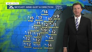
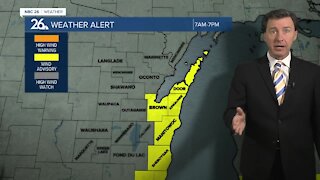
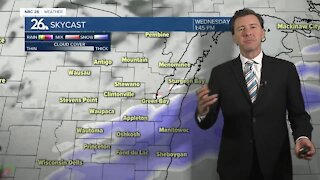
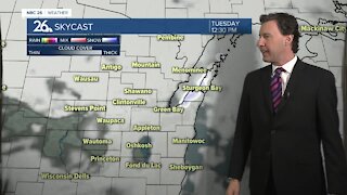
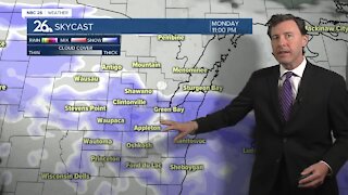
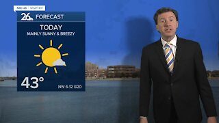
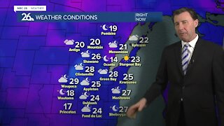
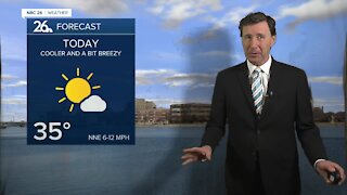
Snow, possibly mixing with drizzle, is on the way for today. It will develop through the morning and last through the day, then tapering off through the evening. Green Bay and the Fox Valley most likely will see 3-5", farther north gets 5-7", though the far SE like Fond du Lac, Manitowoc and Sheboygan should stay a little lower at 2-3". We may mix in some drizzle this afternoon into the evening. Highs will be in the low-30s and it get quite breezy. This won't be one of the heaviest snows we've seen, but it won't be just a little nuisance either. Dry weather returns Thursday and Friday with temps in the low- to mid-30s. This upcoming weekend there is the potential for some more snow/mix/rain on Saturday into Saturday night, before changing over to mostly snow on Sunday. It's too early to make the exact call on any snowfall amounts, but this storm has the potential to be a big one across parts of the area. Stay tuned. It's looking more & more like this could be the snowiest February on record with the potential of more snow next week.
-
 3:36
3:36
WGBA
7 months agoWill it be necessary to have both the AC & the heat on during the same day??
961 -
 2:33
2:33
WGBA
3 years agoMichael Fish's NBC 26 weather forecast
4 -
 2:19
2:19
WGBA
3 years agoMichael Fish's NBC 26 weather forecast
3 -
 2:26
2:26
WGBA
3 years agoMichael Fish's NBC 26 weather forecast
4 -
 2:24
2:24
WGBA
3 years agoMichael Fish's NBC 26 weather forecast
3 -
 1:57
1:57
WGBA
3 years agoMichael Fish's NBC 26 weather forecast
2 -
 2:27
2:27
WGBA
3 years agoMichael Fish's NBC 26 weather forecast
4 -
 2:31
2:31
WGBA
3 years agoMichael Fish's NBC 26 weather forecast
7 -
 1:50
1:50
WGBA
3 years agoMichael Fish's NBC 26 weather forecast
4 -
 2:27
2:27
WGBA
3 years agoMichael Fish's NBC 26 weather forecast
1