Gino Recchia NBC26 Storm Shield Weather Forecast
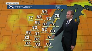
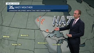
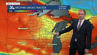
The weather is about to get a bit more messy tonight after another quiet day. We started off sunny but as the day went on, clouds thickened in the area ahead of our next weather system. Winter weather advisories and winter storm warnings have been issued for parts of the area. Winter storm warnings are in effect for Northern Oconto, Northern Marinette, and Menominee County Michigan. Waupaca, Outagamie, Brown, Kewaunee, Door, Shawano, Langlade, Menominee Wisconsin, and Southern parts of Oconto and Marinette Counties are under a winter weather advisory until the morning hours Monday. Tonight, winds will begin to pick up out of the southeast between 20 to 30 mph There is a concern that ice on Lake Winnebago and Green Bay will shift and pile up along the northwest shores creating ice shoves. Some light snow will begin around and after 10 pm tonight, but that snow will quickly transition to a wintry mix and then rainfall for areas south of Highway 10. Between High way 10 and Highway 29, a wintry mix will continue until 5am when it will then change over to rainfall. North of Highway 29, a wintry mix will gradually lift north going into the morning hours. Snowfall accumulation will occur for areas mostly along and north of Highway 29. The highest totals will be to our far northwest in Northern Oconto, Marinette, and Langlade counties where 3 to 6 inches of snow may fall before it transitions to rainfall. South of those locations a dusting to 2 inches will accumulate to the Highway 29 area. South of Highway 29, you'll be lucky to have any accumulation. Cooler weather follows suit on Tuesday. High temperatures will rise into the lower to mid 30s with light snow showers . Although it will turn colder........no big shots of arctic air are in the forecast for the next 7-days.
-
 1:45
1:45
WGBA
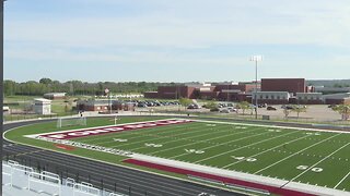
7 months agoFond du Lac Cardinals start the football season with a new $5.3 million nest
63 -
 2:33
2:33
WGBA
2 years agoGino Recchia NBC26 Weather Forecast
15 -
 3:46
3:46
WGBA
2 years agoGino Recchia NBC26 Weather Forecast
13 -
 3:32
3:32
WGBA
2 years agoGino Recchia NBC26 Weather Forecast
17 -
 1:55
1:55
WGBA
2 years agoGino Recchia NBC26 Weather Forecast
9 -
 4:18
4:18
WGBA
2 years agoGino Recchia NBC26 Weather Forecast
11 -
 2:53
2:53
WGBA
2 years agoGino Recchia NBC26 Weather Forecast
13 -
 3:47
3:47
WGBA
2 years agoGino Recchia NBC26 Weather Forecast
1 -
 3:32
3:32
WGBA
2 years agoGino Recchia NBC26 Weather Forecast
6 -
 4:26
4:26
WGBA
2 years agoGino Recchia NBC26 Weather Forecast
1