NBC26 Storm Shield weather forecast
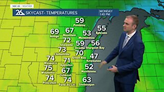
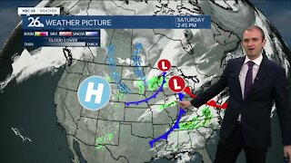
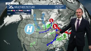
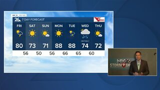
A cold front passes through the area tonight with more areas of showers and T'storms, mainly before midnight. Once again, with the very unstable atmosphere, some of these could bring severe weather with some of the main threats going from gusty wind and hail, to that heavy rainfall, especially the farther south you live. Once this front passes, our overnight temperatures will become more tolerable with readings in the upper-50s. Cooler & less humid weather returns by Wednesday with an isolated shower or sprinkle possible and highs only in the upper-60s to around 70. Wednesday night will be cool and quiet with lows in the upper-40s. Thursday looks very comfortable with sunshine highs in the low-70s. There will be a chance of a shower or T'storm of Friday night into Saturday, but as of now, your Labor Day weekend really doesn't look too bad with highs in the upper-70s to around 80 through Monday.
-
 1:57
1:57
WGBA
7 months agoHow the City of Green Bay is hoping a $1.6M investment will make the community safer for pedestrians
901 -
 4:02
4:02
WGBA
3 years agoGino Recchia NBC26 Weather Forecast
8 -
 3:46
3:46
WGBA
3 years agoGino Recchia NBC26 Weather Forecast
15 -
 2:44
2:44
WGBA
3 years agoGino Recchia NBC26 Weather Forecast
5 -
 3:12
3:12
WGBA
3 years agoGino Recchia NBC26 Weather Forecast
2 -
 4:48
4:48
WGBA
3 years agoGino Recchia NBC26 Weather Forecast
4 -
 2:08
2:08
WGBA
3 years agoGino Recchia NBC26 Weather Forecast
9 -
 3:24
3:24
WGBA
3 years agoNBC26 Storm Shield Forecast
6 -
 3:24
3:24
WGBA
3 years agoNBC26 Storm Shield Forecast
8 -
 1:29
1:29
WGBA
3 years agoNBC26 Storm Shield Forecast
7