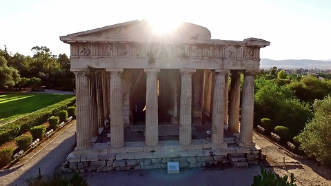
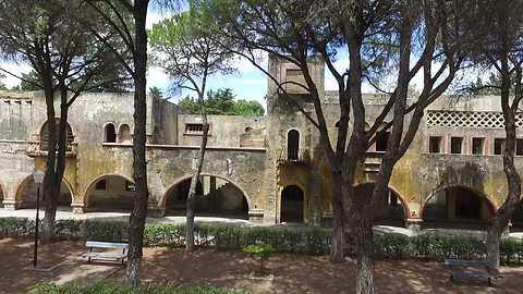
Drone footage of the most well-preserved ancient Greek Temple
Check out this stunning footage of the Temple of Hephaestus near Athens. From the 7th century the building's condition has been maintained due to its history of varied use. Incredible!
243K
views
1
comment
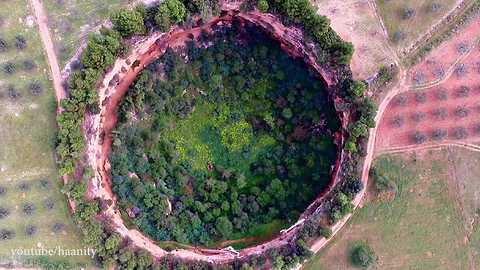
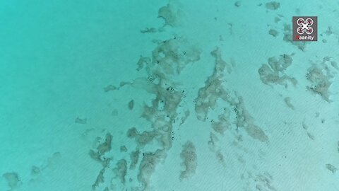
Drone footage reveals bizzare unearthly craters
Scientists speculate that these craters in Didyma, Argolida (Greece) are fallen caves, but their appearance is reminiscent of meteor craters, such as those found on the Moon. The absolute silence prevails in the interior, broken only by the tweets of birds which are heard with echo because of the circular shape of the craters.
65.7K
views
7
comments
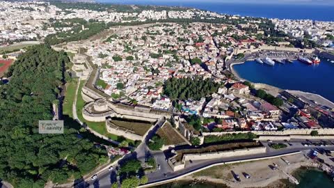
Intact medieval city as seen from a drone
Check out this incredible drone footage of the medieval city of Rhodes in Greece. It is one of the most beautiful urban ensembles of the Gothic period. In the Lower Town, Gothic architecture coexists with mosques, public baths and other buildings dating from the Ottoman period.
46.7K
views
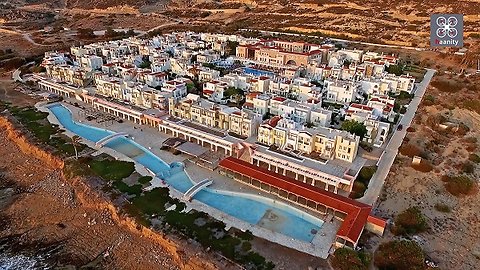
Creepy drone footage captures abandoned settlement in Greece
Enjoy a flight over a place that as beautiful as it may seem, has a dark history. We fly over the settlement of "Dionysos" near Sitia, Crete. In the late 1990's SOE company presented the ambitious plan for the creation of this settlement.
The settlement began to be built, but soon there were quarrels as, among other things, the Analouka Beach next to the settlement collects the most rubbish of the Aegean Sea and so their plans for "idyllic summers in the sand" were reduced to rubble. The current owners are trying to reform the settlement, but it is a difficult project. Check out the cool view from above!
52.8K
views
1
comment
Drone footage captures Italian ghost village in Greece
This ghost village is called Campochiaro, located in Rhodes (Greece) and dates back to 1935-1936. The village was constructed with a Roman Catholic Church (now Greek Orthodox) a school, shops, a Casa del Fascio (formerly with a tower), municipal services, medical facilities and even a cinema. All these buildings were (and are) grouped around a rectangular town square. Hydraulic works were also carried out to allow irrigation and hydroelectric power generation. Amazing!
43.5K
views
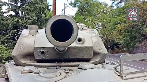
Ypati: The city of Greece that welcomes you with a ...tank!
Usually at the entrances of the cities the artists do their best to make elaborate creations with flowers and other artistic elements in order to impress the visitor.
But there is a city in Greece that instead of flowers, welcomes you with an M24 Chaffee battle tank of World War II. And in fact, there is an important reason for this, as you will read below.
Ypati In Fthiotida region of Greece, is designated as a city of martyrdom because of the atrocity that took place there on Saturday, June 17, 1944.
German Nazi troops burned the city to the ground on this sad day.
This tank at the entrance of the city, serves as an eternal reminder of these sad times and as a warning so that history will not repeat itself in the future.
51.5K
views
2
comments
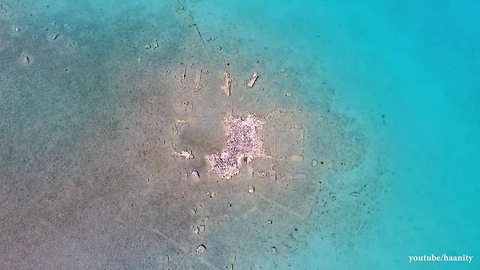
Drone footage captures ancient submerged Greek city
These aerial images show the remains of the city of Porphyra that dates back all the way to the 5th century BC. Enjoy a flight over the walls, streets and buildings of the once glorious city of Halieis.
35.5K
views
4
comments
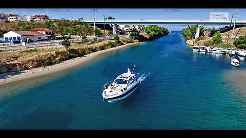
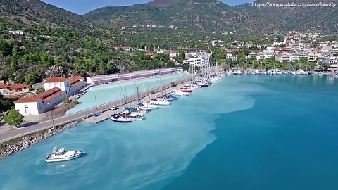
The Canal of Glamour in Greece captured by drone
Enjoy a flight over the the New Potidea Canal in Halkidiki Greece, where the pine trees reach the turquoise waters and boats are mooring under the houses. It is the canal that separates the first leg of Halkidiki in two. It is unknown exactly when it was opened, but certainly it existed before the 1st century AD. The work was completed, probably by Cassander 300-400 years earlier and gets its current form recently, between 1935 and 1937.
26K
views
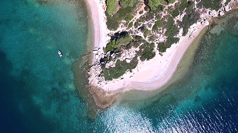
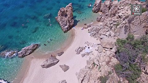
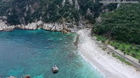
Jaw-dropping drone footage discovers exotic secret in Argolis, Greece
It has no name, but it has incredible, exotic beauty. A special spot along an otherwise rocky coastline, which looks like it came from a tropical place. And yet ... it is located in Argolida, near the village of Koilada (coordinates at the end of the article).
The white sand creates incredible colors that characterize tropical exotic paradises. Few know the point as they are literally in the "middle of nowhere".
Accessible from the nearby rocky shore and by boat and ideal for young people and couples, it is a place in Argolida where we swam and felt that we were in ... Cuba.
An excellent proposal for solitary, exotic dives, near the Argolida Valley, at 2 and a half hours from Athens.
Coordinates: https://www.google.com/maps/@37.4136275,23.1094642,178m/data=!3m1!1e3?hl=en
19.7K
views
5
comments
Stunning drone footage of volcano "spitting" water into sea
Check out these beautiful aerial images from a drone flying over the Methana Volcanic Springs in Greece. In Methana there are many volcanoes that have created this sulfurous pool that pours into the sea. Amazing!
16.1K
views
1
comment
Stunning drone footage of secret Greek island
Egglezonisi (the island of the English man) is a small islet about an hour drive from Athens, Greece. Although it has some majestic beaches, this island has a dark history. It was rented in the 30's by Peter Tervil, an English Archaeologist. He built a villa, which was the only building on the island. In 1941 Peter died in Egypt and later the villa was flattened by aerial bombardment during World War II. Along with the villa, the bombers destroyed much of the vegetation of the island.
15.5K
views
1
comment
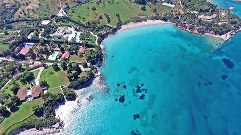
Drone footage captures most expensive house in Greece
Kounoupi, Argolida, Greece - Check out this awesome flight over the most expensive house in Greece, which was put up for sale through the Sotheby's auction house for €20 million!
20.8K
views
Drone Footage Captures An Untouched Beach In Greece
Either science is finally able to capture a flying dream, or we are looking at the beach of Trimi on the border of Mount Athos, Greece. One can be forgiven for believing you are hallucinating. The water is the bluest, most crystal clear water imaginable. The rocks jut from the water’s edge like statues, while the surrounding hills and trees are artfully landscaped by the gods, themselves.
The shape of the cove, a Greek Ω or omega gives visitors a sense of shelter, concealing them from the real world for a time. War, famine, strife, political upheaval? All a distant dream to visitors of the <a href="https://rumble.com/v68lnd-the-most-beautiful-beach-in-the-world.html" target="_blank">beach</a>, which offers no easy access. Only the intrepid can swim to it from a neighboring beach. Otherwise, it can be reached by a footpath over the hill, and by boat, of course.
Spectacular drone footage reveals a stunning coral reef, giving the completely transparent Mediterranean water a mottled hue, from bright aquamarine to London Blue topaz, to shadow. What kinds of sea life might we find below? Those lucky few who arrive by boat could certainly tell us, since they only need fins, a mask, and a snorkel to launch themselves over the hull. Otherwise, they can beach their craft on the sandy shore, or moor to a rocky prominence and have a small slice of the beach all to themselves for a while. They can even hide themselves from other beach goers if they secure a cozy little spot between the magnificent columns.
Astronomers long ago named a large swatch of darkness on the moon the “Sea of Tranquility”, but looking at the lazy, carefree beach people from this vantage point, the name might just as well apply to the waters of the north Aegean Sea. So many islands to choose from. <a href="https://rumble.com/v30lia-10-most-beautiful-beaches-that-will-make-you-want-to-retire-early.html" target="_blank">The water seems to coordinate with the blue sky</a>. Way off to the south east is Limnos. To the northeast is Thassos. The role of Greece in the development of western civilization is seminal, and yet you can hardly tell anything arising from the human mind or hand ever happened here. It’s almost as if we are looking at a forgotten land.
What secrets will be disclosed in soft tones, the beach will never tell. The beach of Trimi was made for the vacation club posters lining cubicle walls all over America. It’s hard to conceptualize a more classical getaway scene than what we see here. How lucky one must be to pilot a drone here. You not only have the perfect equipment for this exciting enterprise, but the weather is on your side, as well.
There will be many a wistful sigh when it comes time to depart our magical beach.
“C’mon guys, you know we have to go sometime. We have pictures, and we’re out of Ouzo.”
The boat kicks backward, away from the sandy shoreline. There’s nothing but blue below and above. You think you can catch a glimpse of Apollo, the sun god Apollo Helios, and the sea god Poseidon, so you wave goodbye to them for now. You’ll be back some day.
16.7K
views
Remote Greek village captured by drone
The Antia villagers speak a unique language of whistles, in which each tone of whistling corresponds to a letter of the alphabet. By putting whistles of different tones in order, they form words. This way, they can talk and understand each other simply by whistling. Children learn the language at the age of 5 or 6.
The interesting custom – which also appears in the nearby villages of Simikouki and Evangelismos – dates back to the times of ancient Greece.
Some speculate that the residents of Antia got the language skills from the Persian soldiers who were guarding Greek prisoners in the Karystos area. After their defeat in the Battle of Salamis, the Persian army left the guards of Karystos behind, and they fled to the highlands around Antia to hide. There they mixed in with the local population and were assimilated by them.
Another theory wants the Antia villagers to be of Doric origin, because they don’t speak the arvanitika dialect like the surrounding populations.
A lesser known theory wants the fathers of the language of whistles to be residents Ainos in Thrace, who moved to the area in 1469 as prisoners of the Venetians.
The “sfyria” language was discovered by mass media in March 1969, when a group of rescuers was searching for the remains of a missing pilot whose plane had crashed in the ‘Ochi’ mountain area.
Although the remaining villagers are still whistling on Antia, its population has shrunk and the area is inhabited by elderly that are slowly dying. The villagers say that they would like to see their whistling language tradition continuing, but their kids mostly have left the village and very few know how to whistle.
17.4K
views
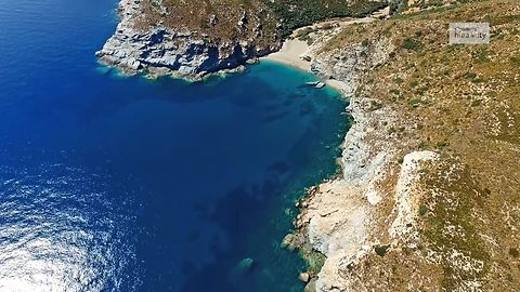
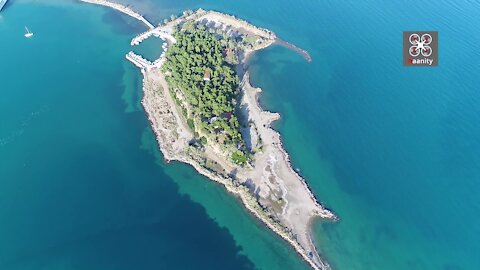
Dog's Cape: A secret exotic paradise in Greece
We discover for the first time an unknown exotic sailor's paradise via drone. Dog's Cape or Tselevinia, Poros, a place endowed with turquoise waters and "blue lakes" where Poros scavengers (and not only) find their refuge to experience the unique beauty of the Greek sea reminiscent of tropical countries.
It is located at the eastern end of the Argolic Peninsula and is the easternmost tip of the geographical district of the Peloponnese. Administratively it belongs to the Region of Attica, the Regional Unit of the Islands of Attica, and in particular to the Municipality of Trizinias. It lies north of the Saronic Gulf, east and south of the Aegean Sea (Argosaronic region). To the east of the cape are two islets, the Dog and the Sword, which are often referred to as the "Celebinia".
Cape Skyllaio along with Cape Sounio and the island of Saint George of Lavreotiki mark the boundaries of the Saronic Gulf.
According to one version, the name Skyllaio comes from Skylla, daughter of the King of the Great Nisos, whose body was washed away in the area.
The name Tselevinia is said to be of Arvanite origin and dates back to the 16th century, when the Arvanites of the area were trying to hide from the Turks who were persecuting them. The Arvanites used the phrase "cellie-veneer" (= watch out for coming) when alerting Turkish ships to approach the area.
The area of Skylai is said to have been inhabited since the Stone Age. The earliest inhabitants are referred to in the literature as the Scyllians, and evidence of ancient human activity is the ruins of a coastal fortress located in the area.
15.7K
views
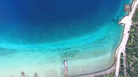
Majestic lake in Greece resembles tropical paradise
Enjoy a flight over Lake Vouliagmeni in Perachora, Loutraki. This small blue lake is just a few meters from the sea and communicates with it through a narrow channel. Its depth does not exceed 40 meters, its length is 2 kilometers and its width is one kilometer. The beach is sandy and with a narrow channel its waters communicate with those of the Corinthian Gulf. From this opening, which does not exceed 6 meters, the sea descends into the lake, forming whirlpools.
Its waters, much safer than the open sea (renewed with the tide and the tidal phenomenon every six hours or so) are at the beginning shallow, and later they are deepening sharply. They are particularly hot and allow swimming until late autumn. The most beautiful beach is on the west shore and is covered with fine white sand. In the lake you will find some taverns with fish and meat.
13.5K
views
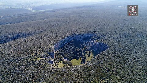
Drone footage captures large earthly crater in Greece
This imposing, secluded crater is awe-inspiring to the few visitors who have seen it. With a diameter of more than 200 meters and a depth of about 40, from the sky it is an incredible, eerie, extraterrestrial spectacle. It is located near the village of Vasiliki in Viotia, Greece and dominates a mountain, remote and inaccessible, as there is no road leading to it.
Scientists are divided when it comes to its origins. Others argue that this is a dolin (collapsed cave). Others are claiming it to be a meteor crater like those on the moon. The absolute silence that prevails inside the crater is broken only by the birds which find shelter in any vegetation that exists in the interior on the crater.
11.9K
views
1
comment
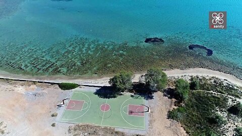
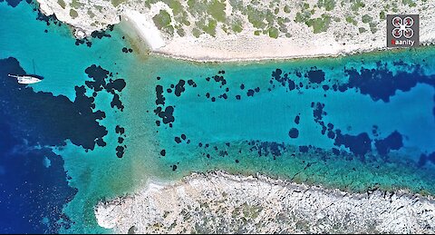
Drone captures exotic Greek basketball court with stunning views
Did you know that in Greece you can play basketball next to the absolute turquoise, overlooking the sea and surrounded by fine sand? We fly over the Strait of Elafonisos, where a surprise awaits us. A basketball court built literally by the sea and on the beach.
We do not know who had the idea, but certainly the result is impressive and original.
Elafonisos does not stop surprising us with its beauties.
A few facts about the island:
Elafonisos is located in the prefecture of Laconia and is the southern tip of the Peloponnese. Elafonisos Island is located between the Malea Peninsula and Kithyra and is a hub on the sea route from north to west (east coast of Peloponnese, Italy) and from north to south or east (Crete, Egypt, etc), therefore holds a major strategic position in the wider maritime space.
The geographical boundaries of Elafonisos include the land and the beach of Pounta (opposite the island) where most of the agricultural crops of Elafonissos are located, but also the extremely important wetland, Lake Strongyli. The opposite coast of Pounta, the islet that mediates, Pavlopetri, the islands of Panagia Kasella, Lepto island and Prasonisi, as well as the islet of Aglyftis are the land part of Elafonisos.
Elafonisos used to be a peninsula (ancient name of Onou Gnathos). The neck that connected it to the opposite shore was cut off and thus the island was formed. The neck has been changed until today in a 500m channel. and depth up to 3m.
Recognized independent settlements of Elafonisos are Kato Nisi and Kapari (census 1991), Pounta and Lefki (census 2001). Punta, located on the opposite coast, is about 550m from the island.
Elafonisos is about 49 km from Molaous, 4 nautical miles from Kithyra with which it is separated from the Strait of Elafonisos and about 27 nautical miles from Gythio.
Elafonisos has a total area of 22 sq.m. km (18 sq. km inside the island and 4 sq. km outside it) and a total perimeter of 31.2 km.
10.6K
views
5
comments
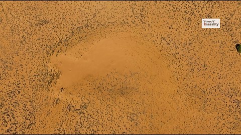
Drone view of Greece's unknown desert
Enjoy an enchanting flight over the desert of Greece, a place where the sand covers everything and there is little vegetation. Thousands of years of sand accumulation from the western winds that usually blow in the area have created this eerie landscape that resembles the Sahara. The minimal trees that exist try to survive in these adverse conditions. The dunes dominate the area and make the spectacle of flying above them unique.
10.2K
views
1
comment
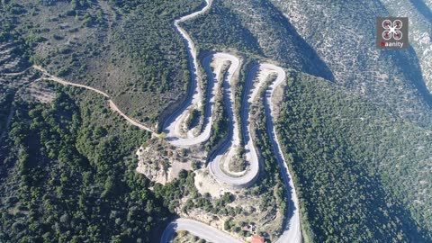
Kolosourtis Highway: A legendary road full of U-turns
The old national road Argos-Tripolis, which was marked with consecutive thirty or more turns on the barren masses of Ktenias to its col, Palialona, is one of the most famous roads in Greece, the only communication formerly with the central Peloponnese, known as Kolosourtis, passing through Ahladokambos to end up in Tripoli.
The terrible "Kolosourtis" gives us its ascent of one of the most enchanting views of Argolida as we see from above to the Argolic Gulf and Nafplio. In the middle of the ascent in the wilderness of the landscape high in the saddle a deserted picturesque country center and a demolished fortress of the German occupation.
Kolosourtis was once the largest road carmaniola in Greece. In its original design it included all the goodies: it was very narrow, it had 180 degree turns glued to the cliff with a sloping slope and slippery road, it had no signage, it had no bars, and from here all the traffic to Tripoli and southern Peloponnese passed, since it was the only road. When it rained or snowed, only the lucky ones managed to pass him without an accident. The dozens of iconostasis set up at the scene of the accidents had formed a sad ensemble resembling a cemetery.
Today, however, this is not the case. After the delivery of the new national road Corinth-Tripoli to traffic, all trucks and most cars go from there and the road of Ahladokambos has little traffic. In addition, it was redesigned from the beginning, widened, acquired bars, markings, correct cornering inclinations, and most importantly, an incredible non-slip road. Now Kolosourtis can now be renamed "Pear Speed Track"! Wear your good tires, adjust your suspensions and come to scratch your cheeks on the most enjoyable road for sporty driving in Greece! The same wonderful situation continues after the col of Agia Paraskevi to Tripoli, except that the road has much less and not so closed turns. Total kilometers of the "track", about 40.
At eleven kilometers of turns, an opening to the plain of Ahladokambos, between Ktenia and Partheni, is deleted to the south. On the right, a 4 km road between barren mountainous areas leads to Nera, where the village of Palioskafidaki was located. There are springs and plane trees and an old Byzantine church rebuilt by expatriates. A small cool oasis, where the big festival of Ahladokambos, Agia Paraskevi took place, with a lot of food, feasting, song and dancing.
In this area are placed the ancient "Keghreai", to the right of "Trochos", the road that led from Argos to Tegea on the heights of the plateau of Isia. A path above Daoulis the inn, a few meters south of the fork to the Waters, leads to some traces of the ancient Kechrei, polygonal walls and various ruins.
9.88K
views
Wild beauty of Pelion, Greece captured from drone
Flying over the wild and rugged terrain of the Pelion coast is simply breathtaking. Sea, ravine, and green tied harmoniously in a landscape that seems untouched by time. Enjoy the beach of Damouchari, shots from the village of Agios Dimitrios and the ruins of the Venetian castle on the hill that separates the two beaches.
8.33K
views

Rare drone footage of mysterious craters in Greece
Enjoy a flight over these craters located in the area of Pelei Argolida.
The western crater has a diameter of 215 meters and the eastern 230 meters.
These giant imposing craters awe the visitor. From above they are an incredible, eerie, alien spectacle.
Scientists are divided over their origin. Others claim that it is a doline (cave top that fell down) - but there is no cave nearby and it must have been huge if it existed - and others claim that it is a meteorite crater, like those on the moon.
The absolute silence that prevails inside them is broken only by the chirping of the birds that find shelter in the vegetation that exists inside them.
9.33K
views
7
comments
Abandoned island of dreams in Greece is totally destroyed
Enjoy a flight over the Island of Dreams or Pezonisi in Evia, a place with great prospects, but lost along the way.
Just two hours from Athens there is an unknown, deserted island with deep blue, heavenly waters, wide sandy beaches, and tall, lush trees.
Next to Eretria in Evia, a small island became known in the 60's as the "Island of Dreams" and attracted visitors from all over the country, who wanted to enjoy moments of tranquility near the lush vegetation.
The most impressive thing about this abandoned paradise today is the fact that you can reach the island on foot, since it is connected by a small strip of land with Evia. That is why they call it Pezonisi.
The island looks like an extension of the port and its beaches are blue and crystal clear. 3 decades ago in Pezonisi there was a big hotel and many restaurants, but for many years the facilities have been abandoned for bureaucratic reasons.
However, anyone can get there, walk and enjoy swimming in crystal clear, unspoiled waters.
In the late 60's Pezonisi was an attraction for visitors from all over Greece and the world. After the change of government and after a tender, the land was given for use to the company Rest Club AE, which invested hundreds of thousands of euros in equipment.
Around 2008, however, the company handed over the property after the eviction of the Municipality of Eretria. The information states that the tenant left because it turned out that there had been no previous public tender and in fact a direct assignment was made with a rent of 100,000 euros per semester.
The property has been unsolicited since 2008, while a proposal for the development of the island made by the Greek-American businessman Lambros Angelopoulos, "stuck" in the incredible bureaucracy and the controversy between the municipality and ETAD, which finally in 2012 forbade to proceed with proceedings exploitation without its permission. Thus the island remains untapped.
10.1K
views
1
comment
Drone captures secret exotic paradise island in Greece
Enjoy a flight over Proti Island in Messinia, a peculiar and beautiful island, a breath away from Marathopolis of Messinia. When you see the island from afar, it resembles of a half-sunk Crocodile.
It has only one beach, Vourlia, which features turquoise, exotic waters and a few meters from the beach, the 40-foot Shipwreck of the ship Anuar, which was bombarded in 2nd World War. and lies a few meters below sea level in the sheltered bay of Vourlia.
The island has one permanent resident, the monk of the Monastery of IM. Dormition of the Virgin of Gorgopigi, which is the only building on the island. In the islet one can also see half-crumbling ascetics today, seafront inscriptions on the rocks and ruins of the ancient acropolis.
There, the Athenian ships that had come down from Zakynthos to Pylos had fallen in search of shelter during the Peloponnesian War and had fallen into terrible shame. During the Turkish occupation, the island was the home of Maniatis Pirati Katatulia, who attacked sailing ships.
Worth a visit!
9.48K
views
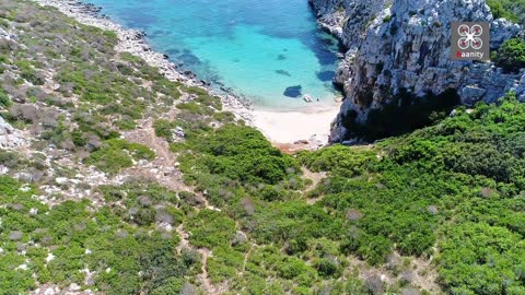
Drone footage captures world famous Mylopotamos Beach in Greece
Milopotamos is a white pebbled beach, with exotic crystal water of unique beauty. It is divided by rocks into two sections with a snaky path leading from one part to another. Pine trees are shadowing the path leading to this beautiful beach. Above the beach there is a beach bar and few lovely taverns. The best possible beach for your next vacation!
7.01K
views
2
comments